| Above: A September 4, 2019 aerial view of damage caused by Category 5 Hurricane Dorian in Marsh Harbour on Great Abaco Island in The Bahamas. Photo by Scott Olson/Getty Images. |
Recovery efforts are underway in southeast Texas after the devastating rains unleashed last week by Tropical Storm Imelda, the fifth-wettest tropical cyclone in continental U.S. history. Imelda made landfall as a minimal tropical storm with 40 mph winds southwest of Galveston, Texas, on September 17, less than two hours after getting named. At landfall, Imelda was traveling northward at just 5 mph, and it maintained a generally northward motion at between 3 and 7 mph for the next 48 hours, gradually weakening. This excruciatingly slow pace allowed Imelda to dump rains of up to 43.39” over southeast Texas, causing catastrophic flooding that killed five. Imelda’s price tag will undoubtedly be in the billions.
Radar loop over the last 24 hours, centered over Houston.
— Tomer Burg (@burgwx) September 19, 2019
Absolutely relentless torrential rainfall continues over SE Texas from TD Imelda. Semi-stationary rain band is still ongoing - will only add to the >40" of rain already observed. pic.twitter.com/Ubv3je1Yor
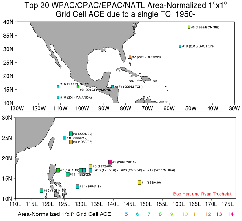
This year’s strongest storm, Hurricane Dorian, also moved agonizingly slowly at landfall when it pounded The Bahamas. Dorian meandered at less than 2 mph as a Category 5 hurricane over Grand Bahama Island and Great Abaco Island, causing catastrophic storm surge, wind, and fresh-water flooding. Damage is estimated at $7 billion or higher—a huge fraction of their $12 billion GDP, and by far the most expensive disaster in Bahamian history. According to CSU’s Dr. Phil Klotzbach, Dorian tracked only 25 miles in 24 hours—the second shortest straight-line distance tracked by an Atlantic major hurricane in a 24-hour period since 1950. Only Hurricane Betsy in 1965, which tracked 12 miles in a 24-hour period, was slower.
 |
| Figure 1. Accumulated Cyclone Energy is a measure of the total destructive power of a hurricane season, based on the number of days strong winds are observed. The ACE index for an individual storm is computed by squaring the maximum sustained winds of the storm at each 6-hourly advisory, and summing up over the entire lifetime of the storm. In this image, the globe was divided into a 1°x1° grid, and the top 20 tropical cyclones (TCs) by ACE index since 1950 were plotted by grid box. Hurricane Dorian’s extremely slow motion as a Category 5 storm over a 1°x1° grid cell centered over the northern Bahamas allowed it to accumulate 13 ACE units; this ranked first all-time in the Atlantic, and second globally behind Typhoon Nida of 2009 in the Northwest Pacific. Image credit: Bob Hart, Florida State University, and Ryan Truchelut, WeatherTiger. |
Joining Dorian and Imelda in the slow-motion catastrophic Atlantic storm club in recent years were Hurricane Florence of 2018 and Hurricane Harvey of 2017. Florence killed 53 and caused over $24 billion in damage to the southeast U.S. after hitting North Carolina as a slow-moving Category 1 hurricane. Hurricane Harvey, which meandered over southeast Texas and the adjacent waters for days, killed 89 and was the second most expensive hurricane of all-time, with $128 billion in damages. Both hurricanes unleashed all-time record rains over their landfall regions due to their very slow motion, with Harvey’s 60.58” setting the all-time U.S. rainfall record for a tropical cyclone.
Hawaii has also seen a record-breaking slow-moving hurricane recently—Category 5 Hurricane Lane. From August 22 - 25, 2018, Lane slowed from a forward speed of 9 mph to 3 mph just west of the Big Island, which recorded the second-highest rainfall on record from a U.S. tropical cyclone: 58.00”. Though Lane never made landfall, its rains made it Hawaii’s third costliest hurricane ever, with damages of $250 million.
 |
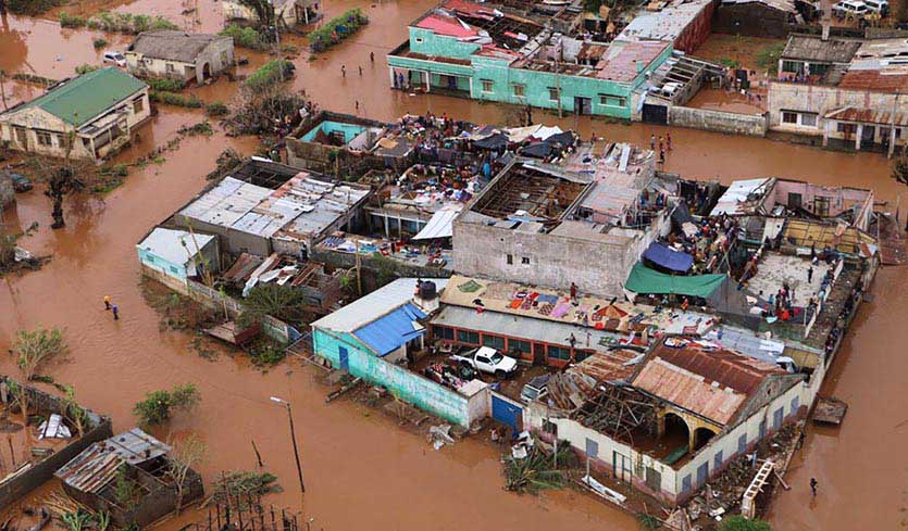
| Figure 2. Residents stand on rooftops in a flooded area of Buzi (population 200,000), in central Mozambique, on March 20, 2019, after the passage of Tropical Cyclone Idai. Image credit: ADRIEN BARBIER/AFP/Getty Images. |
A slow-motion hurricane catastrophe also hit Africa this year, as Tropical Cyclone Idai made landfall near Beira, Mozambique on March 15 as a Category 2 storm. Idai was moving slowly at landfall, near 6 mph, and was a prodigious rainmaker, with satellite-estimated rainfall amounts in excess of 2 feet over much of central Mozambique. Huge portions of the country were submerged for days and over 1,000 people died. Damage was estimated at $2.2 billion, mostly in Mozambique, whose GDP is just $12 billion.
Atlantic tropical cyclones have been slowing down and stalling more often
Imelda, Dorian, Florence, Harvey, and Idai are examples of storms we have been seeing more often in recent decades: ones that move more slowly over land, resulting in increased flooding and damage. The forward speed of tropical cyclones (which includes all hurricanes, tropical storms, and tropical depressions) has decreased globally by about 10% since 1949, according to a 2018 paper in the journal Nature by NOAA hurricane scientist Dr. Jim Kossin. As a result of their slower forward motion, these storms are now more likely to drop heavier rains, increasing their flood risk. Most significantly, the study reported a 20% slow-down in storm translation speed over land for Atlantic storms, a 30% slow-down over land for Northwest Pacific storms, and a 19% slow-down over land for storms affecting the Australia region. (See my June 2018 post, Observed Slowdown in Tropical Cyclone Motion May Portend More Harvey-Like Rainstorms.)
Two 2019 papers also published in Nature, “Uncertainties in tropical-cyclone translation speed” by John Lanzante, and “Climate change and tropical cyclone trend”, by Il-Ju Moon, et al., challenged Dr. Kossin’s results. The two papers asserted that sudden “change-points” in the historical database caused by the introduction of satellite data could have biased the global results towards slower-moving storms, due to the increased detection of weak tropical cyclones over water closer to the equator where slower-moving storms are more common.
In a June 2019 reply, Dr. Kossin responded to their concerns, acknowledging that they might be valid over ocean areas, but not over land, where positions are measured directly—not by satellite. He presented new data showing that the highest quality and longest-running storm speed dataset that we have for tropical cyclones—for ones over land in the continental U.S. beginning in 1900—has showed a significant slowdown, which should be independent of the introduction of satellite measurements. Kossin's analysis of a 118-year data set over the continental U.S. from 1900 to 2017 found a 17% slowdown in the forward speed of tropical cyclones over land.
A June 2019 paper by Timothy Hall and James Kossin (open access) found that in addition to moving slower over land, North Atlantic tropical cyclones have become increasingly likely to “stall” near the coast, spending many hours in confined regions: at least 48 hours inside of a circle 400 km in diameter. In an email, Dr. Hall affirmed that Imelda fit well within their definition of a stalling tropical cyclone, since it spent 52 hours inside of a circle 200 km in diameter; Harvey and Florence also were stalling storms by their definition.
The 2018 study by Kossin and 2019 study by Hall and Kossin did not attempt to attribute the slowdown and stalling behavior to human-caused climate change, saying: “there is not at present a clear mechanism explaining the observed tropical cyclone speed reduction.” However, in an email, Dr. Kossin said, “the vast majority of the models consistently predict a slowing of the tropical circulation due to human-caused global warming. So, in my opinion, given that tropical cyclones are somewhat passively carried along in these winds, a reasonable hypothesis is that they are slowing down with warming. This is fairly compelling evidence for a human fingerprint on the slowing we're observing.”
 |
| Figure 3. The departure of sea surface temperature (SST) from average for September 16, 2019—the day before the formation of Tropical Storm Imelda. SSTs in the western Gulf of Mexico were near 30°C (86°F)--about 1°C (1.8°F) warmer than average. Image credit: NOAA. |
Texas’ second-hottest August on record heated up waters that fed Imelda’s rains
Texas experienced its second-hottest August on record last month, and this near-record heat heated up the waters of the western Gulf of Mexico, helping fuel Tropical Storm Imelda’s rains. Water temperatures in the western Gulf of Mexico on September 16, prior to Imelda’s formation, were near 30°C (86°F)—about 1°C (1.8°F) warmer than average. For each degree Celsius of ocean warming, about 7% more water vapor can evaporate into the air, and hurricanes can act to concentrate this moisture to generate much heavier rains than a simple linear 7% increase in rainfall per degree C of ocean warming. Human-caused global warming made near-record hot temperatures like Texas and the western Gulf of Mexico experienced in August more likely to occur.
Getting more rain from a landfalling tropical cyclone due to its slower motion, plus an additional increase from more moisture in the atmosphere due to evaporation from warmer oceans, is likely to cause significant problems for flood defense systems designed for a 20th-century climate. For an example of how extra rainfall from a global warming-charged tropical storm may have been enough to reach a tipping point and overwhelm flood defenses, causing hundreds of millions of dollars in damage, see my 2011 post, Tropical Storm Lee's flood in Binghamton: was global warming the final straw?
Related:
Protective Wind Shear Barrier Against Hurricanes on Southeast U.S. Coast Likely to Weaken in Coming Decades, our June 2019 post.
Highly Unusual Upward Trends in Rapidly Intensifying Atlantic Hurricanes Blamed on Global Warming, our February 2019 post.
Dangerous Rapidly Intensifying Landfalling Hurricanes Like Michael and Harvey May Grow More Common, our October 2018 post.
Extreme Hurricane Rainfall Expected to Increase in a Warmer World, our June 2018 post.
Observed Slowdown in Tropical Cyclone Motion May Portend More Harvey-Like Rainstorms, our June 2018 post
Will Global Warming Make Larger Hurricanes?, our April 2018 post.
Will Global Warming Make Hurricane Forecasting More Difficult?, our January 2017 post.
Top Ten Tropical Cyclone Events of 2016 Potentially Influenced by Climate Change, our December 2016 post.
Extreme 'Grey Swan' Hurricanes in Tampa Bay: a Potential Future Catastrophe, our July 2016 post.
Hurricane Patricia's 215 mph Winds: A Warning Shot Across Our Bow, our 2016 post.
Katrina-Level Storm Surges Have More Than Doubled Due to Global Warming, our 2013 post.
Damaging Katrina-Level Storm Surges are Twice as Likely in Warm Years, our 2012 post.
Big Money for Hurricane Research, our October 2006 post.


