| Above: Houston Police SWAT officer Daryl Hudeck carries Catherine Pham and her 13-month-old son Alden after rescuing them from their home surrounded by Hurricane Harvey’s floodwaters on August 27, 2017, in Houston, Texas. Image credit: AP/David J. Phillip. |
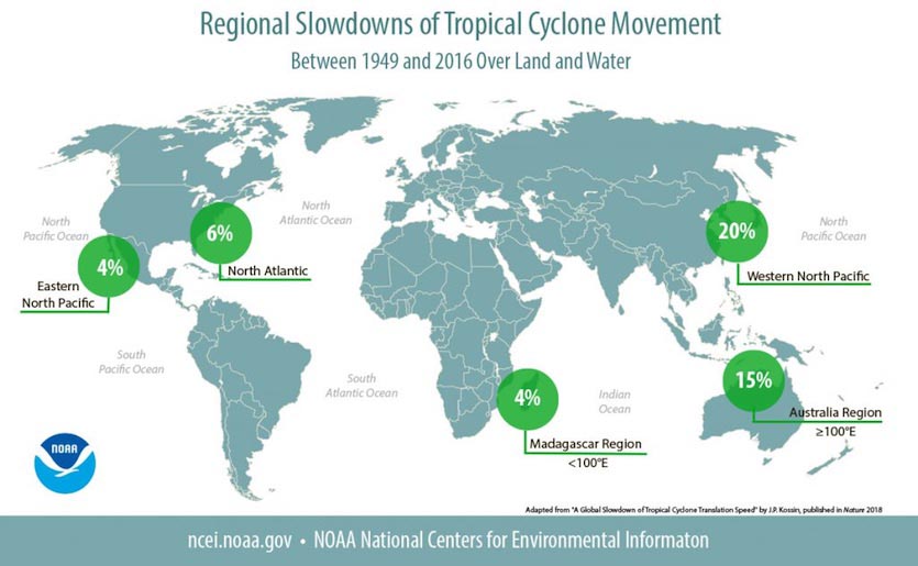
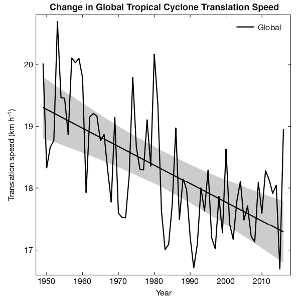
The forward speed of tropical cyclones (which includes all hurricanes, tropical storms, and tropical depressions) has decreased globally by about 10% since 1949, according to a paper published in Nature on Wednesday by University of Wisconsin hurricane scientist Dr. Jim Kossin. As a result of their slower forward motion, these storms are now more likely to drop heavier rains, increasing their flood risk. Most significantly, the study reported a 20% slow-down in storm translation speed over land for Atlantic storms, a 30% slow-down over land for Northwest Pacific storms, and a 19% slow-down over land for storms affecting the Australia region. A storm moving 20% slower over land has the opportunity to dump up to 20% more rain atop a given point over land, increasing the flood risk for flood defense systems designed for a 20th Century climate with less extreme precipitation events. The paper concluded that “these trends have almost certainly increased local rainfall totals in these regions.” Another increased hazard slower storms bring is increased wind damage, due to an increase in the duration of damaging winds structures are exposed to.
The slow-down was observed in both the Northern and Southern Hemispheres, and in every ocean basin except the North Indian Ocean. Tropical cyclones affecting land areas in the Eastern Pacific, Northern Indian Ocean, and western South Indian Ocean showed no significant trends in translation speed while they were over land.
 |
| Figure 1. Observed slowdowns in tropical cyclone forward speed by ocean basin, 1949 – 2016. Slowdowns over land only were higher in some regions (a 20% slow-down over land for Atlantic storms, a 30% slow-down over land for Northwest Pacific storms, and a 19% slow-down over land for storms affecting the Australia region). Local tropical cyclone rainfall totals would be expected to increase by the same percentage due to the slowing alone. Increases in rainfall due to warming global temperatures would compound these local rainfall totals even further. Image credit: NOAA. |
Comparison to theory and modeling results
Global warming theory calls for summertime winds in the tropics to decrease. Thus, we should expect to see a slow-down in the translation speed of hurricanes in a warmer climate, due to weaker winds pushing the storms along. The observed 10 percent global slowdown occurred in a period when the planet warmed by 0.5°C, so it is plausible to ascribe the slowdown to global warming. It is uncertain if the observed 10% decrease in translation speed since 1949 can be entirely ascribed to human-caused global warming, though, since Kossin did not attempt that kind of attribution study. Also, the paper did not answer the question of why the trends in translation speed varied between ocean basins and on land versus over the water.
Tom Knutson, a research meteorologist at NOAA's Geophysical Fluid Dynamics Laboratory in Princeton, New Jersey noted that his team's climate models do not show a slow-down in future hurricane movement--even if they tweak the models to slow the steering currents that move the storms along. However, there is at least one modeling study that has found that human-caused climate change can be expected to cause a slower translation speed for tropical cyclones: Changes in Hurricanes from a 13-Yr Convection-Permitting Pseudo-Global Warming Simulation, published on May 1, 2018 in Journal of Climate. This study, led by Ethan Gutmann of the National Center for Atmospheric Research (NCAR), looked at 22 Atlantic hurricanes that occurred during the period 2001 – 2013, including Wilma, Rita, Sandy, Isaac, Ike, Ivan, Isabel and Gustav. The high-resolution WRF model (4 km grid spacing) was run for each storm using the current climate, and then for a climate approximately 4.5°C (8°F) hotter--the amount of warming expected by end of century if no attempt is made to control greenhouse gas emissions (scenario RCP 8.5). As a group, the 22 storms in the future simulation had 6% stronger average hourly maximum wind speeds than those in the past, moved at a 9% slower speed, and had a 24% higher average hourly maximum rainfall rate.
 |
| Figure 2. Global time series of annual-mean tropical cyclone translation speed and their linear trends from 1949 - 2016. Gray shading indicates 95% confidence bounds of the trend. Image credit: Kossin, 2018, A global slowdown of tropical-cyclone translation speed, Nature volume 558, pages 104–107 (2018). |
Hurricane Harvey’s rains worsened by a slow storm translation speed
Global warming could have increased the record rainfall of Hurricane Harvey by contributing to a slow-down in its motion. However, Harvey's record rainfall amounts were primarily due to the fact the storm stalled out and performed a loop over the coast, and Kossin's study did not evaluate how global warming may or may not be changing the frequency of such "stalled track" looping behavior.
There is already one study out that has researched this issue, though: Wang et al. (2018), “Quantitative attribution of climate effects on Hurricane Harvey's extreme rainfall in Texas”. Using a global climate model that tracked Harvey-like stalled systems, the researchers found that their model predicted an increase in the number and intensity of these stalled storms over southeast Texas through the mid-21st century. They cautioned, though, that the results may be different running other models.
Sources of error in the study
We should always be wary of research showing trends in historical tropical cyclone activity, since these storms are hard to measure, and we did not get full global satellite coverage until about 1982. However, Kossin’s data shows the global slow-down in tropical cyclone translation speed occurring during both the pre-global satellite period of 1949 - 1982, and the period since, giving increased confidence that the observed slow-down is real. Furthermore, measuring the average speed of a storm over a multi-day period is not that hard to do, since position errors at one particular point will not greatly impact the speed measurement along the whole track.
Global warming’s impacts on tropical cyclones: a heavy rainfall double-whammy
Since global warming is confidently expected to increase how much rain tropical cyclones produce because of an increase in the amount of water vapor evaporating from warmer oceans (there is about 7% more atmospheric moisture per degree Centigrade of warming), future hurricanes may produce more heavy rains from both increased moisture in the air and a slower translation speed. It is plausible that local rainfall increases could actually be dominated by this slowdown rather than the expected rain-rate increases due to more moisture in the atmosphere.
Getting 20% more rain from a landfalling tropical cyclone due to its slower motion, plus another 20% increase due to more moisture in the atmosphere is likely to cause significant problems for flood defense systems designed for a 20th Century climate. For an example of how extra rainfall from a global warming-charged tropical storm may have been enough to overwhelm flood defenses and cause hundreds of millions of dollars in damage, see my 2011 post, Tropical Storm Lee's flood in Binghamton: was global warming the final straw?
A slowdown in forward speed also affects storm surge
Storm surge modeller Joannes Westerink of Notre Dame pointed out to me that a slowdown in forward speed of landfalling tropical cyclones also has a big impact on the storm surge. A slower-moving storm will:
Dr. Kossin was one of four hurricane scientists that wrote an excellent May 30 realclimate.org post, Does global warming make tropical cyclones stronger?


