
Above: Elaine Powell speaks with relatives on her cell phone as she surveys the remains of her boyfriend's campers and property, in Carson, Miss., on Monday, April 13, 2020, a day after severe weather struck the area. (AP Photo/Rogelio V. Solis)
A well-predicted outbreak of severe weather more than made its mark from early Sunday into Monday from the South to the mid-Atlantic. As of 4:30 PM EDT Monday, 32 fatalities had been reported, according to weather.com. Assuming these are confirmed to be tornado-related, this outbreak appears to be the deadliest single tornado event since the catastrophic tornado in Joplin, Missouri, that killed 158 people on May 22, 2011.
Hundreds of homes across the South are in ruins, and countless snapped trees have been strewn across the landscape. More than 1.2 million homes and businesses, including close to 500,000 in North and South Carolina, were without power in eight states as of 10:30 a.m. EDT Monday, according to PowerOutage.us.
At least seven of the fatalities came from a tornado that plowed through two manufactured home parks in Murray County, Georgia, northeast of Atlanta.
One of the larger communities to experience a direct hit was Monroe, in northeast Louisiana, at midday Sunday. About 300 homes were damaged or destroyed in Monroe, police Sgt. Chuck Johnson told The Weather Channel. The Monroe airport received substantial damage as well, making it one of at least four U.S. airports to experience a significant tornado hit this spring. On top of this, an apparent tornado came within roughly a mile of Atlanta’s Hartsfield-Jackson International Airport—the world’s busiest—early Monday morning. See Marshall Shepherd’s writeup in Forbes for more on this event.
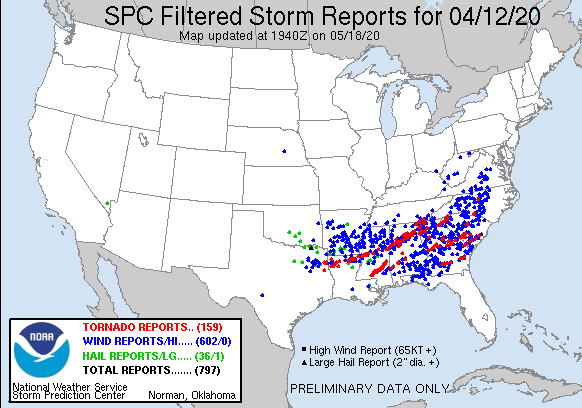
The NOAA/NWS Storm Prediction Center has received at least 51 preliminary tornado reports for the period through 8 am EDT Monday, with another eight reports since then. These numbers are likely to rise. Very little large hail was reported east of Texas, but there were more than 400 reports of severe wind gusts.
A broken line of intense and sometimes tornadic storms ripped through the Southeast on Sunday night and Monday morning. This squall line moved off the coast by late morning, but severe weather continued to the north. A tornado watch was in effect through 6 pm EDT Monday evening for much of the mid-Atlantic, including Washington, D.C., and Philadelphia.
Some of the twisters in the Carolinas and Virginia were surprisingly intense for line-embedded storms occurring in the morning hours, a reflection of the extreme values of wind shear and instability present during this event. Postdoctoral researcher Tony Lyza (University of Alabama Huntsville) analyzed radar data in detail from a strong tornado near Charleston, South Carolina, and estimated that winds just above the surface might have been as strong as 169 mph.
The NWS has confirmed EF3 damage with the tornado below, near Livingston, SC, with surface winds estimated at 140 mph.
NWS survey teams will be combing through wreckage starting Monday to determine which tornadoes were the most intense. A twister that tore through the city of East Chattanooga, Tennessee, has already been rated at least EF3 by the NWS office in Morristown, and an EF2 tornado was confirmed southeast of Stonewall, Louisiana, by the NWS office in Shreveport.
Perhaps the most stunning tornadic storms on Sunday—at least on radar—were a pair of long-lived tornado-producing supercells that tracked one behind the other across southeast Mississippi. In some places, the damage tracks were separated by only about three miles.
In a mesoscale discussion issued at 4:26 pm CDT Sunday, SPC pulled no punches: “A violent tornado with potential peak winds of 170 to 205 mph is likely ongoing.”
Social media leapt to declare that both of these storms had produced EF5 tornadoes, but it remained to be seen at midday Monday whether or not the tornadoes from either of these jaw-dropping storms will be confirmed as an EF4 or EF5—and that, in turn, will hinge on the vagaries of exactly what the tornadoes hit, since the EF-scale determination is currently based only on observed damage rather than radar returns. Experts are now working on ways to incorporate radar data into EF ratings.
One of the quirkier outcomes of Monday’s tornadoes was a house blown onto a highway in Upson County, Georgia, south of Atlanta (see embedded tweet below). David Roueche, an engineer and wind-damage expert at Auburn University, attributed the movement to a likely lack of a fixed foundation. “Homes like this one that moved typically sit on unreinforced (i.e., not filled with grout or steel rebar) masonry block stem walls or brick masonry piers. The wood floor joists [rest] on the walls with maybe a few concrete nails into the block or similar if anything at all.” He added, “The concerning part is that when the anchorage is the first element to fail, the house is much more susceptible to complete collapse.”
See the weather.com article for more on the widespread impacts from this outbreak.


