| Above: An aerial photo taken on Tuesday, May 28, 2019, shows damaged homes and debris marking the path of an EF4 tornado that struck Celina, Ohio, on May 27. The most recent U.S. tornado that was officially rated EF5 tore across Moore, Oklahoma, on May 20, 2013. Image credit: Ryan Snyder/Daily Standard via AP. |
This guest post is from Jonathan Belles, a meteorologist at weather.com
Doppler radars around the country gained a new ability to analyze tornadic thunderstorms when they were outfitted in the early 2010s with dual-polarization (dual-pol) technology. The new dual-pol metrics provide meteorologists with important clues on exactly when and where tornadoes begin and end and where they are causing destruction. New research is now building confidence in the ability to estimate damage potential in real time and to better warn communities that are still in the storm’s path.
This new approach, which got attention during the widespread severe weather in late May, comes on the heels of multiple research projects that are connecting radar velocity and radar-indicated debris to the Enhanced Fujita Scale.
One of the new features that dual pol brought to the table is the ability to detect debris being lofted on radar.
The function that allows us to "see" this debris is called correlation coefficient, and it tells meteorologists how much the objects in thunderstorms vary in size (or how correlated they are). In a typical thunderstorm, most objects are similar to the ones next to them (think of a batch of raindrops). But in a tornado-producing thunderstorm, a lot of different kinds of objects are swirling around.
Sometimes the correlation coefficient shows a large contrast in airborne objects, from rain to everything else. This may show up in a distinct fingerprint that has been informally been called a debris ball, or more formally a tornado debris signature (TDS).
This tool, combined with more traditional radar variables like velocity (seen at left in Figure 1), might be the key toward a new way of rating tornadoes.
 |
| Figure 1. The EF4 tornado that struck the Dayton, Ohio, area on May 27, 2019, was detected in NWS Doppler radar by velocity (wind speeds, on left) and correlation coefficient (sameness of objects, on right) at 10:51 PM EDT. The tornado was not at its maximum intensity at this point. |
Three tiers within tornado warnings
Dr. Vivek Mahale is a meteorologist at the NWS/Norman office serving central and western Oklahoma, which is among the nation’s most experienced offices at dealing with tornadoes. Mahale explains that NWS offices issue three types of tornado warnings based on the information forecasters have at the time a warning is needed, including radar data as well as visual confirmations from storm chasers, local media, and members of the community.
A “generic” tornado warning is used when a tornado is possibly occurring but there is no confirmation. These warnings are issued when there is some hint of circulation of radar or a sighting of a funnel cloud.
From there, the NWS uses tags and enhanced wording to convey two heightened levels of danger based at least in part on radar velocities and debris signatures. The first of these tags, found toward the bottom of tornado warnings, is “considerable.” A considerable tag indicates there is a possibility of a significant tornado, EF2 or higher, according to Dr. Mahale.
Then there is the “catastrophic” tag, which is equivalent to a tornado emergency, which means there might be a violent tornado, an EF4 or stronger.
The NWS hopes that these heightened tornado-warning tags will lead more people to take safety precautions.
A new way of estimating tornado strength
Some scientists are now trying to relate tornado intensity to how much debris is dragged up into the sky and how far up into the atmosphere it goes, to provide communities with an estimate of damage potential while the storm is still under way.
Sam Emmerson, a graduate student at the University of Oklahoma, is one of those scientists.
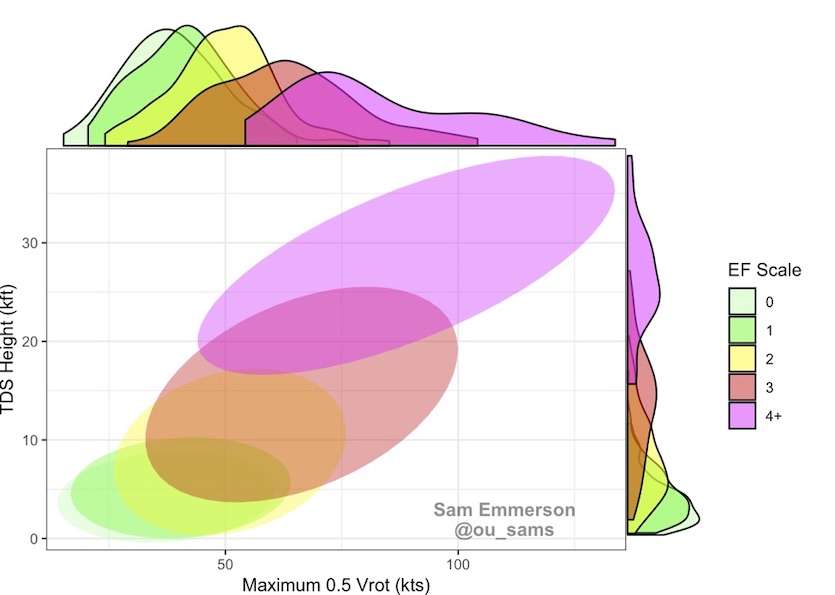
He has developed guidance for meteorologists that offers a suggestion of how strong a tornado is based on how vigorous the rotation is above a tornado and how high debris is being lofted. Emmerson used a couple of years of radar data and tornado ratings to develop this guidance.
 |
| Figure 2. Suggestions of tornado damage potential (center) based on debris height (left) and velocity at the lowest radar tilt (bottom). Image credit: Sam Emmerson. |
The National Weather Service (NWS) has had official guidance for several years on the connection between the height of a tornado debris signature and the potential strength of a tornado. This guidance has been used in forecaster training since 2016. Emmerson’s findings are in rough agreement with the NWS guidance, thus lending support to the concept.
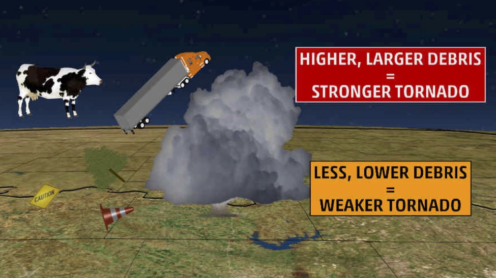
In general, the higher debris is being thrown into the atmosphere, the stronger the tornado is likely to be.
 |
| Figure 3. A stronger tornado will generally throw bits of whatever they hit higher into the atmosphere. Stronger tornadoes will also loft larger objects, but many of these won’t make it high enough to hit the radar beam. (Note that cows and trucks will not be lofted to the top of the storm, as is shown here for effect!) |
“If we use characteristics from that [tornado debris signature], you can essentially gauge how intense a tornado might be,” Emmerson said. The technique isn’t meant to give an exact EF rating, which can only be done after damage is surveyed, but Emmerson says it can provide a general sense of whether a tornado is most likely weak, strong, or potentially violent.
Emmerson hopes that these estimations will be used in tornado warnings to provide more detailed information.
 |
| Figure 4. Guidance used in NWS training depicting estimates of tornado strength based on radar data. Source: NWA Journal of Meteorology and NWS Warning Decision Training Division. |
The NOAA/NWS Storm Prediction Center has also been working on using radar to help get an idea of tornado strength. In 2017, SPC forecasters published a paper in the journal Weather and Forecasting indicating that there was a clear link between the rotational speed of a circulation and tornado intensity on the ground.
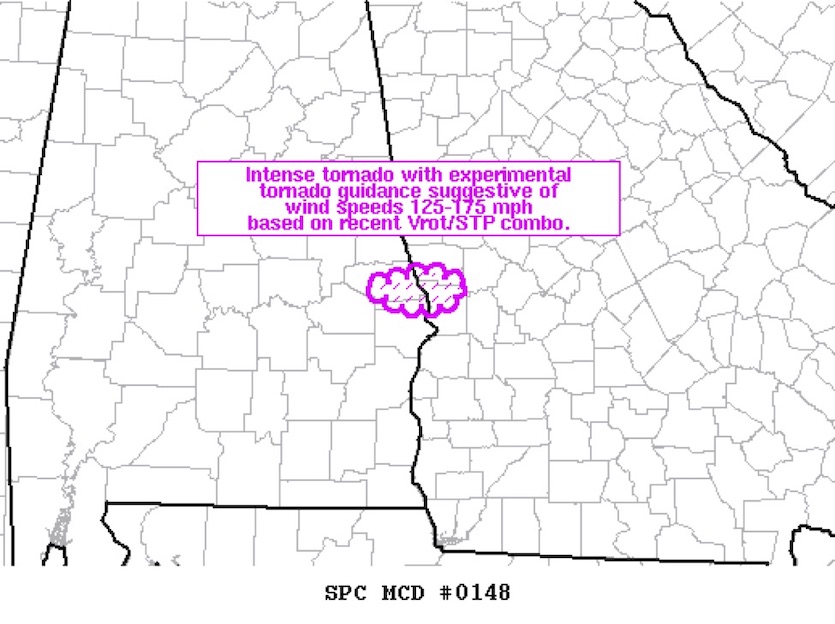
In March 2019, the center used this guidance to actually estimate the wind speeds of a tornado that struck Lee County, Alabama as it was still on the ground.
 |
| Figure 5. A mesoscale discussion released at 2:19 PM CST estimating wind speeds of the Beauregard, AL, tornado of March 3, 2019, using wind data from radars and the significant tornado parameter (environment) of the area. Image credit: NOAA/NWS/SPC. |
After the severe weather ended, the NWS surveyed the damage and found damage that suggested maximum wind speeds of 170 mph occurred. The tornado was responsible for killing 23 people and injuring 90 more.
Debris isn’t all the same
There are some caveats to using radar in place of damage surveys, though.
First, tornadoes have to hit something to produce debris. This has always been a caveat with the Fujita and Enhanced Fujita scales, since F and EF ratings are based exclusively on damage to structures, trees, and other objects. In areas where there is sparse vegetation and lots of distance between towns and cities, such as the High Plains, forecasters may not have enough of a debris signature to rate an ongoing tornado. That same tornado may not leave enough damage for a traditional EF rating later on.
Emmerson also noted that weaker, short-lived tornadoes may not be accurately rated since they don’t last long enough to loft enough debris.
On the flip side, Emmerson points out, if a tornado strikes an area rich with many bits of small vegetation, such as leaves or corn debris in a freshly harvested field, large amounts of debris can be lofted to great heights. This would produce a stronger debris signature than the tornado’s actual intensity would imply.
The NWS also cautions that radars seldom detect the below-cloud part of a tornado. Rather, they usually sense the tornado-spawning circulation within the thunderstorm itself, due to how radar beams rise relative to the ground as they extend further from the radar site.
 |
| Figure 6. A simulated radar beam and tornadic thunderstorm showing that most radar imagery detects circulations well above a tornado. |
A case study
The NWS office in Wilmington, Ohio recently used debris heights to estimate tornado strength during an outbreak that produced nearly 20 tornadoes on May 27-28.
Debris from the EF4 tornado that struck Trotwood and Dayton was detected as high as 24,000 feet, according to Ken Haydu, meteorologist in charge at the NWS/Wilmington office. “When we start to see debris above 20,000 feet, we know that we have an 80% chance that we have an EF3 tornado in contact with the ground,” Haydu says. “So what that means to the people living there is that we knew at that point that we had winds over 130 mph occurring.”
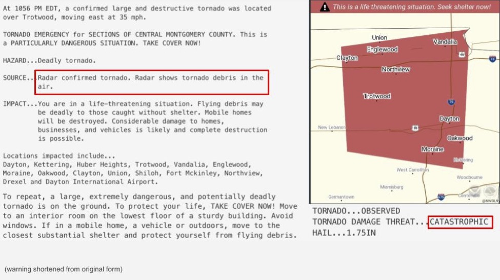
This information was used in real time on the evening of May 27 to issue a tornado emergency for the Dayton area, home to nearly 750,000 people. Tornado emergencies are issued when a catastrophic threat to life or property is imminent or ongoing and there is a confirmed tornado ongoing.
 |
| Figure 7. One of the two tornado emergencies issued in southwestern Ohio on May 27 by the NWS office in Wilmington, Ohio. A second one was issued to the east and southeast of the one above. Image credit: NWS. |
“When I came to work the next day, I was expecting dozens, if not hundreds of fatalities,” Haydu said. However, nobody died in areas that were placed under tornado emergencies that night.
Haydu credits the dual-pol radar information used in the messaging of tornado warnings to saving lives that night.
“We were able to put ‘particularly dangerous situation’ into the warnings and really highlight that,” he said.
Haydu also credits the tone of local broadcast meteorologists and The Weather Channel during the tornado warnings, as well as NOAA Weather Radio, smartphones, and family members. He also said that the time the tornadoes occurred - the night of Memorial Day - meant that people were largely at home and reachable.
Emmerson noted that his research accurately pegged the Trotwood/Dayton tornado as likely being strong and potentially violent.
Based on a peak Vrot of ~80 kt and and peak TDS height of 24,000', the Dayton, OH tornado was likely within the 160-170 mph range, corresponding to high-end EF3 to low-end EF4 intensity. #ohwx pic.twitter.com/YGU6xWz3iJ
— Sam Emmerson (@ou_sams) May 28, 2019
Is it time to revise the Enhanced Fujita Scale?
The original Fujita Scale was introduced in 1971 by Dr. T. Theodore Fujita as a way to categorize tornadoes using the damage they did and the areal extent of the damage done. Since that year, official tornado ratings have always been determined after the fact, based on damage and nothing else.
The scale, now the Enhanced Fujita (EF) scale, has been updated several times over the last four decades to address building integrity and architecture and provide better estimates of wind speeds.
But now the scale might need another update.
The aforementioned research on debris and velocity signatures on radar, combined with new building codes, may call for another revision – or even a possible addition – to the current scale.
James LaDue has a unique perspective on tornadoes and how they are rated, both as they are occurring and in damage surveys. LaDue is chair of the Wind Speed Estimation Standards Committee, a joint venture between the American Meteorological Society (AMS) and the American Society of Civil Engineers (ASCE).
This committee is actively trying to update the standard for how wind speeds in tornadoes are determined, both by radar in real time and damage surveys. The standard in tornadoes is the Enhanced Fujita Scale.
LaDue is also an instructor for meteorologists at the NWS Warning Decision Training Division, meaning he trains incoming meteorologists how to warn for severe weather phenomena like tornadoes.
LaDue notes several modifications are needed to the current Enhanced Fujita scale to account for new building codes and to acknowledge radar and weather-station wind speed estimates that have become much more widespread since the EF scale was unveiled in 2007.
Based on how his committee’s work has evolved, LaDue thinks that tornado ratings may soon come with two different numbers: one for damage (i.e. EF2) and one for radar-indicated wind speeds, thus providing more precision than we currently have. He hopes to have as many different methods to rate tornadoes as science will allow, in order to increase the confidence in both damage-potential messaging and to help engineers who will be using the data to design wind-resistant structures.
The wind speeds attached to a scaled number (e.g., EF1, EF2) are only the end product of a great deal of architectural, engineering and meteorological knowledge that continues to evolve and improve.
Behind the scale are 28 damage indicators that are directly tied to wind speeds. Every object – homes, trees, malls, and power poles – damaged or destroyed is examined by meteorologists and engineers, using one of the 28 damage indicators to determine how strong the winds were when they hit the object.
Some of these objects are changing. For instance, building codes for new homes are being strengthened and new homes might require stronger wind speeds to cause particular damage to them, such as roof removal or exterior wall collapse. Interestingly, even how trees are looked at is changing based on new knowledge of botany. This requires the EF scale to adapt.
Using radar data to rate tornadoes: A renewed discussion
The debate over whether or not tornadoes should be rated purely on damage has come up before.
In 2013, an erratic, intense, and heavily watched tornado tore through Canadian County, Oklahoma, close to the town of El Reno and just west of Oklahoma City. The tornado was on the ground in mostly rural country, but several homes and other structures were heavily damaged and eight people were killed in vehicles. At 2.6 miles, this tornado was the widest on record anywhere.
None of the damage surveyed and documented by the NWS/Norman office suggested winds any higher than EF3 strength, or higher than 165 mph.
 |
| Figure 8. This photo shows EF3 damage from the tornado of May 31, 2013, to a house near the intersection of Rother Road and SW 15th Street, or about 6 miles south-southeast of El Reno, OK in Canadian County. All of the walls of the house collapsed. Image credit: NWS/Norman. |
As is the case during many tornado outbreaks, mobile radars were sampling thunderstorms, including the one that spawned this tornado. Both the University of Oklahoma’s RaXPol radar and the Center for Severe Weather Research’s Doppler on Wheels (DOW) sampled the lower levels of the tornadic thunderstorm. In fact, the research radars were precise enough and close enough to measure the tornado itself. The RaXPol radar detected winds over 290 mph, well over the minimum threshold of EF5, which is 200 mph.
This discrepancy created much controversy over the next several months, as the official rating from the NWS went from EF3 to EF5, then back to EF3. The NWS later released a statement saying that their final rating was to be based on damage surveys alone, but acknowledging that the radar data was reliable.
They added that they were “exploring whether policy should change to allow the use of experimental radar data in future EF determinations.”
Six years later, it seems the science is taking important steps in that direction.
Jonathan Belles has been a digital meteorologist with weather.com since 2016. He studied meteorology at Florida State University and continues to enjoy learning about all things tropical.


