| Above: WunderMap composite image of NWS radar data at 6:35 pm EDT Saturday, October 28, 2017, showing Tropical Storm Philippe. |
A disturbance that lingered in the North Caribbean for days is now making a northeastward beeline as Tropical Storm Philippe, the 16th named storm of this very active Atlantic season. In records going back to 1851, this year is now in 10th place for the most number of Atlantic tropical storms and hurricanes.
Centered near the north Cuban coast about 20 miles southwest of Havana at 5 pm EDT Saturday, Philippe was a minimal tropical storm, with top sustained winds of just 40 mph. However, Philippe’s broad circulation of very moist air was allowing the storm to drench the Cayman Islands, central Cuba, and South Florida.
Tropical storm warnings were in effect late Saturday for a number of Cuban provinces and the Northwestern Bahamas. A tropical storm watch was in effect from Craig Key to Golden Beach, Florida, including the middle and upper Keys and Miami-Dade County. At 4 pm EDT, Key West International Airport—about 120 miles north-northeast of Philippe’s center—reported sustained winds of 28 mph with gusts to 37 mph. At the José Martí International Airport in Havana, winds at 4 pm EDT were a mere 8 mph.
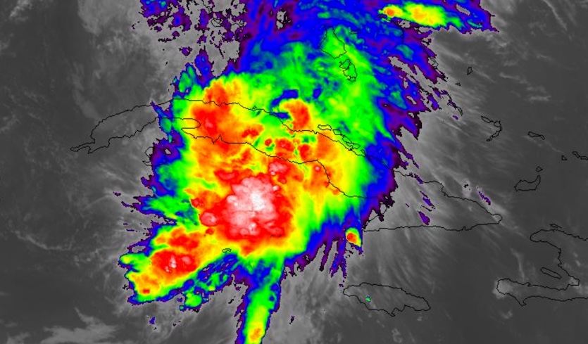 |
| Figure 1. GOES-16 infrared satellite image of Tropical Storm Philippe at 6:32 pm EDT Saturday, October 28, 2017. Image credit: NASA/MSFC Earth Science Branch. GOES-16 images are considered preliminary and non-operational. |
Philippe’s showers and thunderstorms (convection) were becoming elongated from southwest to northeast late Saturday, as strong upper-level winds began to impinge on the storm. Well northwest of the convection around Philippe’s center, a separate batch of heavy rain was moving across southern and central Florida, downstream of a tiny non-tropical low north of Key West. Flood watches extended from Miami to the Vero Beach area, where rainfall totals could run into the 4” - 6” range. A tornado was reported (and photographed) Saturday evening near Palm Beach.
Outlook for Philippe through Sunday
A strong upper-level trough approaching the East Coast will be the main force dictating the future of Philippe, as well as that of a separate coastal storm expected to race north into New York as a powerful midlatitude storm late Sunday into Monday. The two low-level centers—Philippe and the coastal storm—may end up interacting in some form or fashion under the influence of the large upper-level trough.
Philippe was already zipping northeastward at about 30 mph late Saturday afternoon. Short-range models late Saturday suggested that Philippe would be quickly merging on Saturday night with the small non-tropical low to its north. Although Philippe's center may pass near Miami overnight, tropical-storm-force winds are expected to remain mostly offshore. By Sunday morning, Philippe will be racing at 30-40 mph past the Northwest Bahamas, where heavy rains can be expected overnight and a brief period of gale-force winds is possible. As the upper trough injects energy while Philippe is still over warm water (at least 26°C or 79°F), Philippe could become a higher-end tropical storm at some point on Sunday. Given Philippe's poor organization on Saturday night, hurricane strength looks unlikely. This means that Philippe will probably bring to an end the almost-three-month-long streak of ten consecutive Atlantic storms reaching hurricane strength, from Franklin to Ophelia.
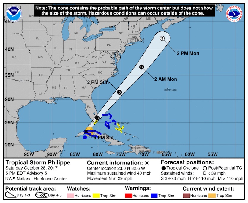 |
| Figure 2. NOAA/NWS/NHC forecast for Tropical Storm Philippe as of 5 pm EDT Saturday, October 28, 2017. Image credit: NHC. |
"Leaf-stripping tempest": Wind impacts from Philippe and the midlatitude storm
There remains a good bit of uncertainty in Philippe’s evolution from late Sunday into Monday and the storm’s potential impacts on New England and the Canadian Maritimes. Models are now in close agreement that Sunday’s separate coastal storm will intensify off the mid-Atlantic and crash ashore late Sunday within about 100 miles of New York City as a powerful midlatitude low, perhaps with a central pressure below 980 mb. It appears that Philippe will be rapidly pivoting around the east side of the coastal low, ripping northward toward eastern Cape Cod and/or the coast of Maine early Monday at more than 50 mph. By this point, Philippe will be well on its way to transitioning into a midlatitude storm, if not already there, but it may retain a warm core for some time even as it becomes asymmetric.
The official National Hurricane Center forecast issued at 5 pm Saturday predicted that Philippe would be a post-tropical storm just south of Nova Scotia on Monday afternoon. Philippe’s actual location at this point will hinge on the complex interaction among Philippe and the midlatitude storm and upper low to its west. The 12Z WRF-ARW and 18Z GFS models suggest that Philippe could end up further west than the NHC forecast, on a faster-moving track.
Regardless of its classification on Monday, Philippe has the potential to bring a pocket of fierce, potentially damaging winds onshore near and east of its center. At the 850-mb level, about a mile above the surface, southerly winds on the east side of Philippe are predicted by the WRF-ARW and GFS to be in the 70 – 100 mph range from Cape Cod to parts of the Maine and New Brunswick coasts (see Figure 3). These winds are unlikely to fully mix down into cooler surface air, but the downward momentum within heavy rain squalls could bring wind gusts topping 70 mph at some spots near the coast.
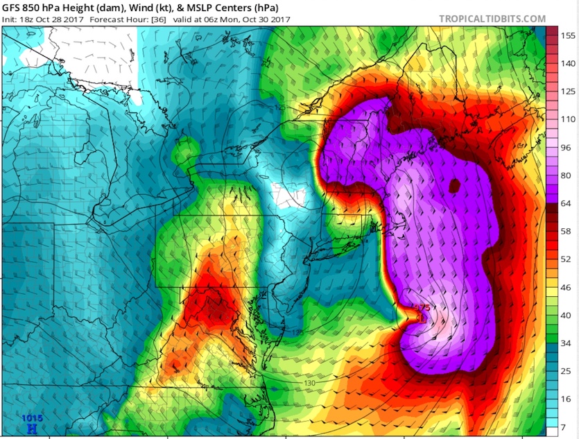 |
| Figure 3. Very strong winds (purple) were predicted at the 850-mb level, about a mile above the surface, by the 18Z Saturday GFS model for 2 am EDT Monday, October 30, 2017. The center of low pressure shown well east of the mid-Atlantic coast is Tropical Storm Philippe. Winds are shown in knots; for mph, multiply by 1.15. Surface winds will be less extreme overall, although stronger winds may briefly mix to the surface during squalls. Image credit: tropicaltidbits.com. |
A short period of very strong easterly winds may also emerge late Sunday into early Monday across northern New England, along the axis from Philippe to the coastal storm as the latter races inland and north through eastern New York. Here again, 850-mb winds may exceed 70 mph, and these winds could at least partially mix down to lower elevations, especially as they will be blowing roughly perpendicular to the north-south-oriented mountains of Vermont and New Hampshire.
Another period of high winds, this time wrapping around from the west, is expected across much of New York and New England on Monday as the midlatitude low screams northward. Westerly gusts topping 100 mph are predicted for Monday at the summit of Mount Washington, New Hampshire. Along and near the southeast shores of Lake Ontario, very high winds and heavy lake-effect rain squalls (perhaps mixed with snow at higher elevations) can be expected.
There could be significant tree damage over parts of New York and New England from the high winds late Sunday into Monday, given that many trees are still leafed out in the wake of a near-record-warm autumn to date. Greg Carbin, chief of the forecast operations branch at NOAA/NWS Weather Prediction Center (and a Vermont native), called the impending storm a potential “leaf-stripping tempest.”
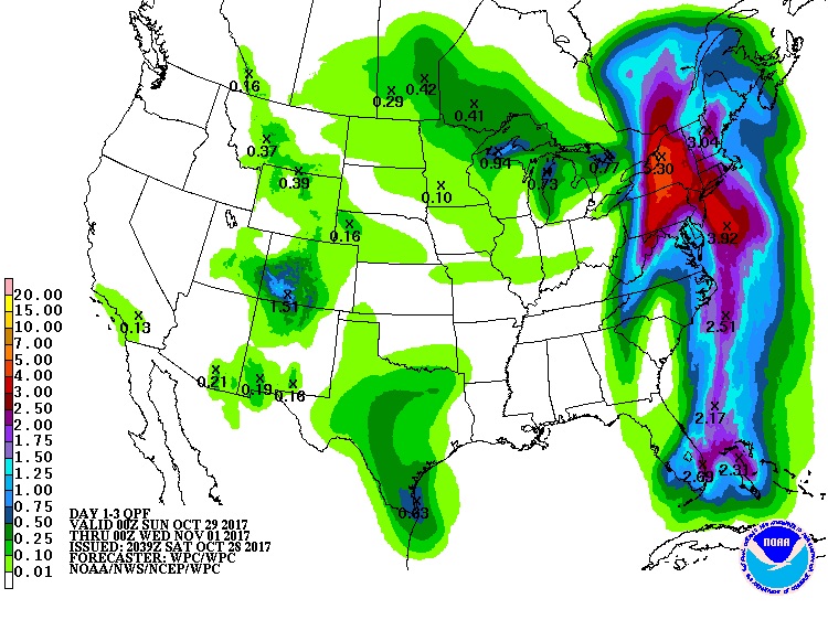 |
| Figure 4. Precipitation forecast (in inches) for the 3-day period from 8 pm EDT Saturday, October 28, 2017, to 8 pm EDT Tuesday, October 31. Image credit: NOAA/NWS/WPC. |
Rain impacts from Philippe and the midlatitude storm
Philippe may bring its own compact area of heavy rain onshore if it takes an inland track. However, the heaviest rains from Sunday into Monday will likely be just west of the stronger midlatitude surface low, especially over western and central Pennsylvania and New York. Totals of 2 – 6” can be expected here, including parts of the greater New York area. Rainfall across this region has been on the light side this autumn, so river flooding is not likely to be a major threat, but flash flooding is possible. Some locations may receive their largest one-day rainfall totals recorded in any October.
It’s also looking very possible that barometric pressure will hit record-low levels for October over parts of New York, and perhaps Maine as well if Philippe moves inland with an identifiable center (see our Friday post for more on this angle).
We’ll be back on Sunday with an update on Philippe and the Northeast U.S. storm.
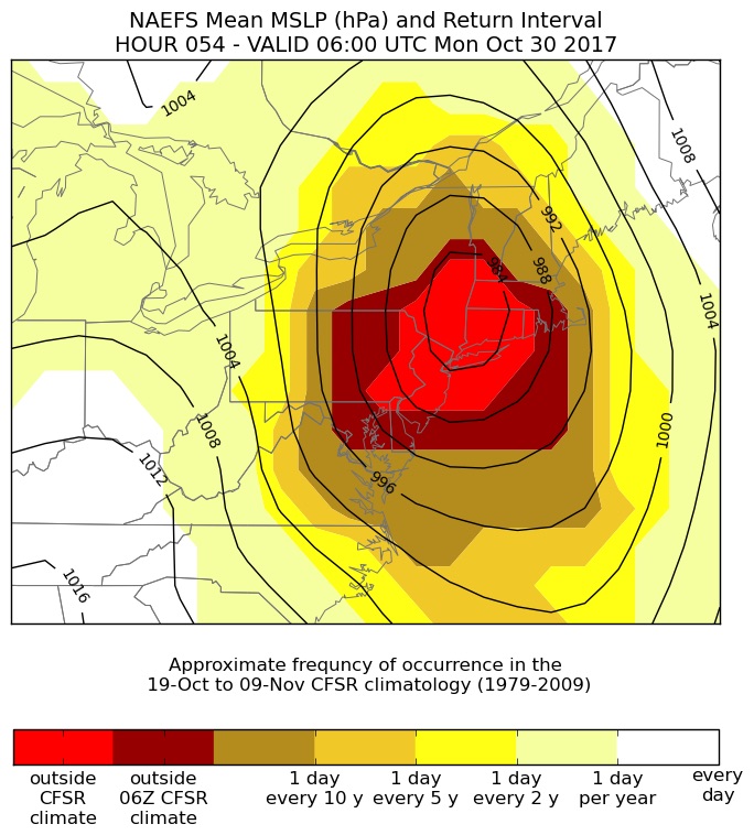 |
| Figure 5. This map shows the rarity of October systems as strong as the midlatitude storm that will move inland near New York City late Sunday night. If the surface pressure pattern adheres to that shown by the contours in this map, much of the region would see surface pressure lower than any observed in the period from Oct. 19 to Nov. 9 in the 30-year climatological period from 1979 to 2009. Hurricane/Superstorm Sandy, which brought even lower pressures south of New York, struck in late October 2012, outside this 1979-2009 window. Image credit: Greg Carbin, NOAA/NWS Weather Prediction Center. |


