
| Above: Infrared GOES-16 satellite image of tropical disturbance 93L, located between Central America and Cuba at 2 pm EDT Friday, October 27, 2017. At lower left is compact Tropical Storm Selma, which will bring heavy rains to Guatemala and El Salvador this weekend. Image credit: NASA/MSFC Earth Science Branch. GOES-16 images are considered preliminary and non-operational. |
Hurricane Hunters were en route Friday afternoon to the Northwest Caribbean, where a long-simmering tropical disturbance showed increasing signs of organization. Models support the idea that the disturbance, called Invest 93L, could become a tropical depression or tropical storm as it moves across Cuba, near South Florida, and through the Bahamas this weekend. In addition, moisture from the vicinity of 93L will get swept northward, helping to juice a powerful midlatitude storm expected to slam parts of the U.S. Northeast from Sunday into Monday. [Update: At 5 pm EDT Friday, the National Hurricane Center upgraded 93L to Potential Tropical Cyclone 18. The PTC designation, introduced earlier this year, applies to systems that are not yet full-fledged tropical cyclones but that could intensify and bring tropical-storm conditions to land areas within the next 48 hours. Tropical storm warnings have been issued for parts of Cuba and The Bahamas. Although the Hurricane Hunters found winds of tropical storm strength within PTC 18, there was not yet a well-defined center of circulation.]
At 2 pm EDT Friday, the center of 93L was located just off the eastern tip of Honduras. As it’s drifted north over the last 24 hours, 93L has moved into a frontal zone stretching from the Northwest Caribbean into the Northwest Atlantic. Reinforcement from converging low-level winds along this front appears to have given a boost to 93L, with an expanding area of strong showers and thunderstorms (convection) beginning to consolidate.
Intensity forecast for 93L
Wind shear around 93L is on the decrease: the 12Z Friday run of the SHIPS model predicts that shear will be less than 10 knots from midday Friday until Saturday evening. The mid-level atmosphere is quite moist (around 70%) and sea-surface temperatures are very warm (around 30°C or 86°F). There is also a pool of high oceanic heat content centered in the Northwest Caribbean, which would lend further support to any development. Together, the above factors will give 93L a brief window of very favorable conditions for development before shear begins to rapidly increase on Saturday night. This may be enough time for a tropical storm to form, although the increasing shear, the limited time frame, and the expected interaction with Cuba make it very unlikely 93L would reach hurricane strength.
The GFS and European model ensemble forecasts from 00Z Friday gave 93L a 50-70% chance of becoming a depression and a 25-30% chance of intensifying into a named storm. None of the 70 ensemble members generated a hurricane. In its 2 pm EDT tropical weather outlook, NHC gave 80% odds that 93L would develop into at least a tropical depression by midday Sunday. The next name on the Atlantic list is Philippe.
 |
| Figure 1. Visible GOES-16 satellite image of tropical disturbance 93L as of 1:45 pm EDT Friday, October 27, 2017. Image credit: RAMMB / CIRA @ CSU. GOES-16 images are considered preliminary and non-operational. |
Track forecast and potential impacts from 93L
The track forecast for 93L is straightforward, thanks to a strong upper-level trough moving into the eastern U.S. that will capture 93L over the weekend. 93L should continue to drift north through Friday night, then accelerate northeastward from Saturday into Sunday ahead of the trough. It now appears less likely that 93L will be interacting directly with the intense surface low that's predicted to form off the East Coast and race northward Sunday in association with the upper trough. Instead, 93L will more likely merge with the strong front that will sweep ahead of the trough from the Southeast U.S. into the Northwest Atlantic late Sunday.
Heavy rain is the main threat from 93L. Track models are in close agreement that 93L will move across central Cuba late Saturday, most likely as a weak tropical storm, then accelerate across the Bahamas early Sunday. The increasing motion will cut back on potential rainfall totals, but a swath of 2 – 6”, with locally higher amounts, can be expected across the Cayman Islands, central Cuba, and the Northwest Bahamas, along with gale-force winds. Across South Florida, widespread 1 – 4” totals can be expected, in part due to interactions with the approaching upper-level trough.
 for the 3-day period from 8 pm EDT Friday, October 27, 2017, to 8 pm EDT Monday, October 30") |
| Figure 2. Precipitation forecast (in inches) for the 3-day period from 8 pm EDT Friday, October 27, 2017, to 8 pm EDT Monday, October 30. Image credit: NOAA/NWS/WPC. |
Record October rains, high winds possible over Northeast U.S. late this weekend
Moisture from 93L will be funneled across the eastern U.S. in an atmospheric river on Saturday and Sunday, ahead of the approaching upper trough and cold front. Several north-south belts of heavy rain can be expected, with “training” cells moving from south to north along the corridors as they slowly translate east. One belt of heavy rain may produce 1 – 3” totals on Saturday along and west of the Appalachians, from Mississippi to Ohio. A second, more intense corridor will take shape Sunday from the mid-Atlantic coast and central Appalachians into eastern New York and New England. Widespread 2 – 6” amounts are possible, with even higher local totals, and flash floods are a distinct possibility. The heavy rain could extend eastward into New Hampshire and Maine, where there is some risk of river flooding as a result of heavy rains there in recent days.
A corridor of strong winds (perhaps 40 – 50 mph, with higher gusts) may slam into the coast just east of the surface low, roughly from Cape Cod to Maine, on Sunday night. The odds of damaging wind appear a bit lower than they did yesterday, given that it seems less likely there will be direct interaction between the surface low and 93L.
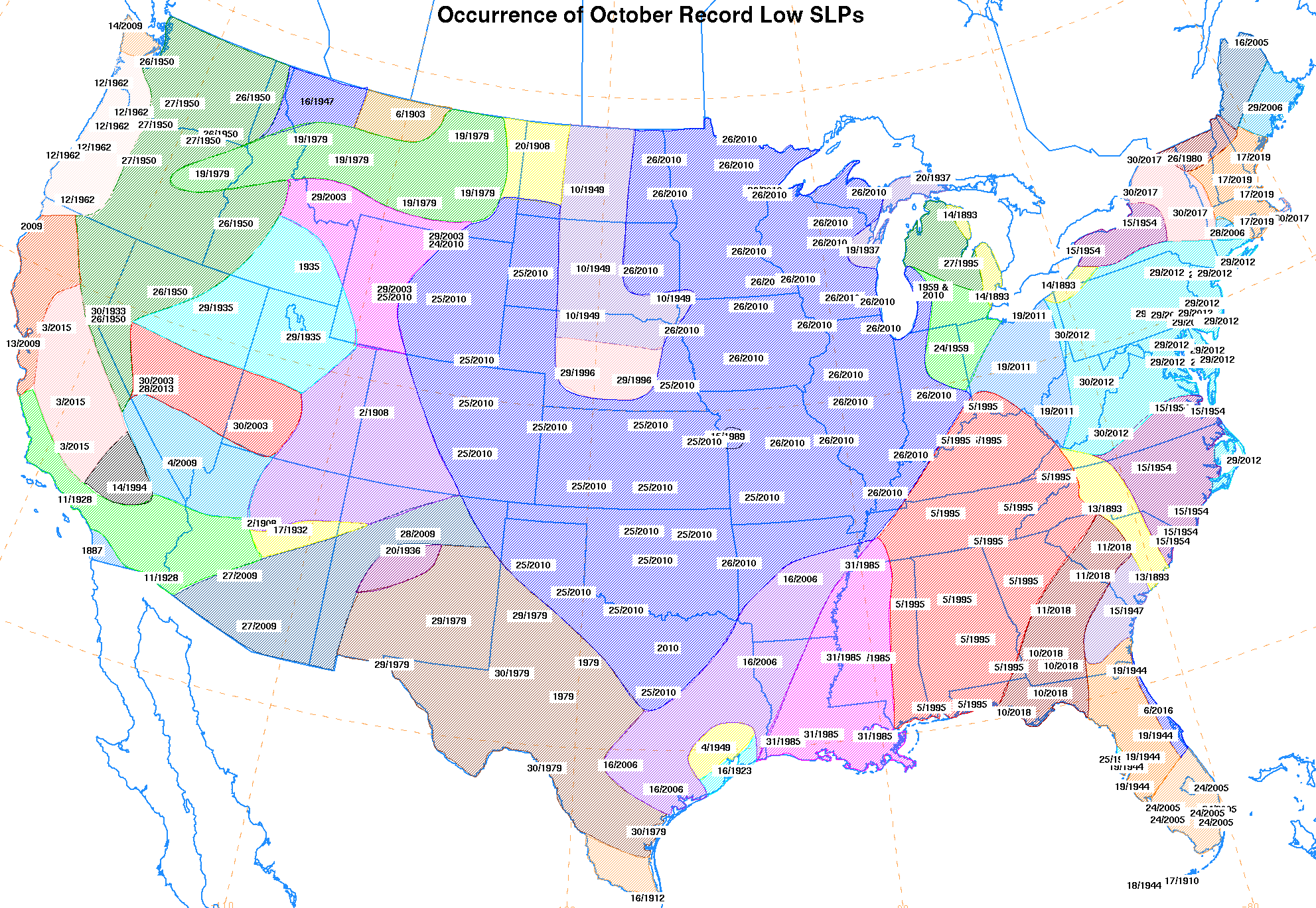
Some locations in the Northeast may well set all-time records for their heaviest calendar-day rainfall total during any October. There’s also a chance that barometric pressure will dip to all-time lows for October at one or more points across New England as the surface low zips northward on Sunday night. Multiple models are suggesting that the low may be deeper than 980 mb, while the October records north and east of New York are mostly between 978 and 983 mb (see Figure 3).
 |
| Figure 3. Lowest sea-level air pressures ever recorded in October for the U.S. Northeast. Values are in millibars and tenths of millibars, with the preceding 9 omitted: e.g., "793" = 979.3 mb. Most of the records along the Northeast coast were set during Hurricane Sandy (October 2012) or during a storm in October 2006; the day and year for each location can be found at this link. Image credit: NOAA/NWS Weather Prediction Center. |
 |
| Figure 4. Visible satellite image of Tropical Storm Selma at 1:45 pm EDT Friday, October 27, 2017. Image credit: NOAA/NESDIS. |
Dangerous rains and floods possible in Central America from Tropical Storm Selma
On the other side of Central America from 93L—but part of the same broad swath of moisture and disturbed weather—tiny Tropical Storm Selma materialized on Friday morning in the far Northeast Pacific. At 11 am EDT, Selma was located about 160 miles south of San Salvador, El Salvador. It’s almost unprecedented to get a newborn tropical cyclone this far east. Selma is only the second Northeast Pacific storm ever to be christened east of longitude 90°W, not counting tropical cyclones that moved from the Atlantic into the Northeast Pacific and got renamed. (The other such storm was Tropical Storm Alma, in May 2008.)
Selma is not only small but also quite weak: top sustained winds are a minimal 40 mph, extending out up to 45 miles from its center. SSTs are warm (around 29-30°C or 84-86°F) and the surrounding atmosphere is very moist (74-80% relative humidity). However, moderate to strong wind shear of 15 – 20 mph and, eventually, interaction with the rugged terrain of Central America should keep Selma from intensifying very much. Selma is expected to gradually work its way toward the northwest and north, making landfall on Saturday along the coast of Guatemala or El Salvador. A tropical storm warning is in effect for the coast of El Salvador, with a tropical storm watch for the Pacific coast of Guatemala.
Life-threatening flash floods and mudslides are a distinct threat from slow-moving Selma, despite its weakness and small size. As it approaches the higher terrain of El Salvador and Guatemala, widespread rains of 3 – 6” are expected, with local totals of 10” or more possible.
We'll be back with our next update by midday Saturday at the latest.


