| Above: This business in Celina, Ohio, was among those damaged as an EF2 tornado tore through Celina on Sunday, November 5, 2017. Image credit: Levi A. Morman/The Lima News via AP. |
More than a dozen tornadoes plowed across parts of Illinois, Indiana, Ohio, and Pennsylvania on Sunday. No deaths were attributed to the twisters, but weather.com reported that two men died while investigating a flooded basement in Erie, PA, during the swarm of severe weather. The outbreak included 10 tornadoes in northern Ohio and Pennsylvania confirmed by the NWS/Cleveland office and four confirmed by the office in Wilmington, OH.
The longest-lived tornado on Sunday was a “bi-state” EF2 northeast of Indianapolis that tracked across 39 miles of east-central Indiana and west-central Ohio. Another EF2 formed just downstream and struck the town of Celina, OH, which experienced significant damage and eight injuries, according to WANE.com. Further to the northeast, the security camera at a restaurant in Findlay, OH, captured high winds blowing a windowed storefront onto patrons (there were no serious injuries, fortunately, but the 20-second video is harrowing!).
 |
| Figure 1. The Crown Manufacturing building in Celina had a large majority of the roof taken off, as well as siding on the front and back part of the building. This photo was taken on Monday, Nov. 6, 2017, after a tornadic thunderstorm struck Celina on Sunday. Image credit: Levi A. Morman/The Lima News via AP. |
November tornadoes aren’t so unusual
We’re in the midst of what is sometimes called the “second season” of U.S. severe weather. The most likely setups for tornadic storms involve warm, moist air streaming north at low levels, combined with high winds, strong vertical shear, and cold air aloft. Because of this, the transition seasons—spring and autumn—are the most likely times for severe weather in most of the central and eastern U.S.
The contrast between lower- and upper-level temperatures tends to be less in autumn, when the sun angle is lower than in spring, so the autumn severe-weather season is typically less intense, but devastating fall outbreaks have occurred. Just last year, a post-Thanksgiving outbreak (Nov. 27-30, 2016) killed six people and produced 48 tornadoes across 11 states. A major Midwest outbreak on November 18, 2013, killed 8 people and destroyed hundreds of homes. The top 5 November outbreaks on record each involved more than 60 tornadoes.
Thus far, a fairly average year for U.S. tornadoes
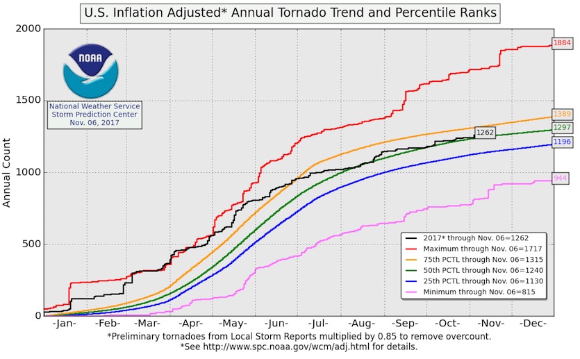
Through Monday, the total number of “inflation-adjusted” preliminary U.S. tornado reports for the year had reached 1262. (In this analysis, the tornado counts are scaled to account for the dearth of reporting in the 1950s vs. the wealth of tornado observations today.) This year’s inflation-adjusted total as of Nov. 6 was very close to the average for the date of 1297. Thus far, 34 tornado-related deaths have been reported—most of those (20) occurring in a vicious outbreak in late January. More than half (19) of the fatalities this year have occurred in mobile/manufactured homes.
 |
| Figure 2. As of Nov. 6, the year 2017 was running close to average in tornado frequency, when adjusted to account for the growth in tornado reporting in recent years. Image credit: NOAA/NWS Storm Prediction Center. |
November heat records obliterated in Dallas-Fort Worth
The unusually warm, muggy air mass for early November that helped produce the Midwest tornadoes on Sunday also led to a few spectacular heat records in Texas, especially in the Dallas–Fort Worth area. Prior to this year, November was the only month in which DFW had never hit 90°F. The city’s hottest November reading in records dating back to 1898 was 89°, occurring on multiple dates/years. That record was demolished in short order with the following highs at DFW:
Thursday 11/2: 94°F
Saturday 11/4: 90°F
Sunday 11/5: 94°F
Later this week, a cold air mass will plow into the central and eastern U.S., potentially bringing record lows to parts of the Northeast, including Boston and New York. The cold will undoubtedly be noticed, given the very mild autumn thus far in the Northeast. Daily record lows are likely, and a few spots could dip toward record-cold readings for so early in the season. However, all-time monthly records are very unlikely given that we’re still in early November. For example, Boston might get as cold as 20°F on Saturday morning, November 11. The record low for that date is 24°F in 1901, while the record coldest for early November is 17°F (Nov. 4, 1889) and the all-time monthly low is a frigid -2°F (Nov. 30, 1875).
 |
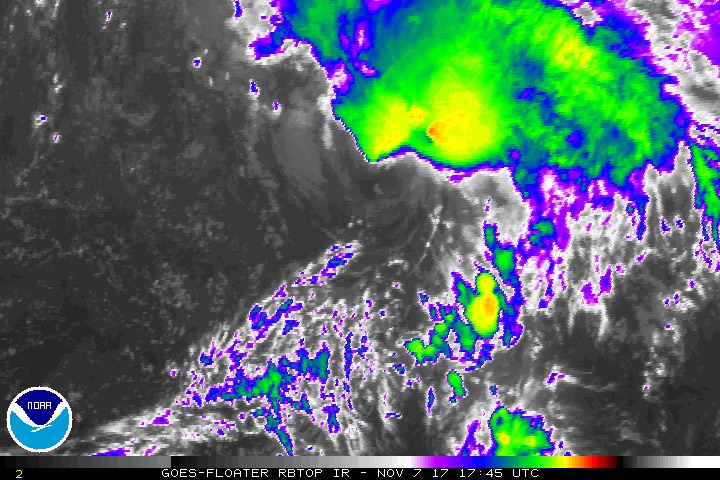
| Figure 3. Enhanced infrared satellite image of Tropical Storm Rina as of 12:45 pm EST Tuesday, November 7, 2017. Image credit: NOAA/NESDIS. |
Tropical Storm Rina holding its own in Atlantic
Christened as the year’s 17th named storm on Monday night, Tropical Storm Rina was maintaining minimal tropical storm strength (sustained winds of 40 mph as of 10 am EST Tuesday) as it began to accelerate northward across the Central Atlantic. Wind shear remains high, around 20 knots, and Rina is now traveling over sea-surface temperatures less than 25°C (77°F). However, unusually cold air aloft is helping provide enough instability to keep Rina’s showers and thunderstorms going. Rina was quickly gaining the look of a subtropical storm on Tuesday, with a comma-shaped field of showers and thunderstorms (convection) mainly north and east of its exposed low-level center.
Most of our intensity guidance suggests Rina could gain a modest bit of strength into early Wednesday, as strong upper-level winds to the north of the storm provide an outflow channel. The NHC forecast as of Tuesday morning was for Rina to intensify into a 50-knot tropical storm by Wednesday, then to rapidly transition to a post-tropical cyclone by Thursday as Rina is swept bodily into the strong mid-latitude flow. Rina poses no threat to land.
Rina likely to become the first “R” storm to fall short of hurricane status
According to Dr. Phil Klotzbach (Colorado State University), 2017 joins a select group of only seven other years since 1851 that have seen a total of 17 named storms in the Atlantic by November 6. The other years are 1933, 1969, 1995, 2005, 2010, 2011, and 2012. Each of those years went on to generate at least one additional storm. According to Cat 6 reader HurricaneFan, all five of the previous “R” storms in the Atlantic (going back to the start of official naming in the early 1950s) were hurricanes. These included Roxanne (Cat 3, 1995), Rita (Cat 5, 2005), Richard (Cat 2, 2010), Rina (Cat 3, 2011), and Rafael (Cat 1, 2012). This year's Rina is also the first "R" storm to develop as late as November.
Syria joining the Paris Agreement
On Tuesday, Syria announced its intention to join the global Paris Agreement on reducing greenhouse gas emissions. This leaves the United States as the only nation in the world planning to opt out of the agreement. See our post from Monday night for more on the ongoing U.N. climate conference in Bonn, Germany, which continues through next week.


