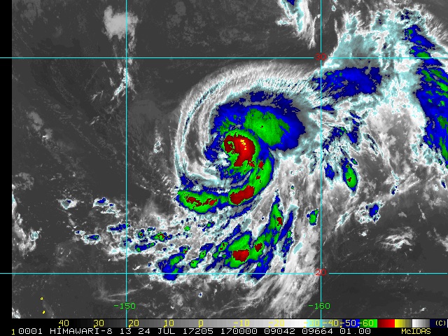
| Above: Infrared satellite image of Tropical Storm Irwin (left) and Hurricane Hilary (right) in the Northeast Pacific at 11:00 am EDT Monday, July 24, 2017. The two cyclones will interact with each other in an unusual way later this week. |
Tropical cyclones have been strewn across the North Pacific over the last several days, while the Atlantic remained free of tropical activity, in an east-west contrast that’s about as sharp as we ever get. On Saturday, there were eight tropical storms and depressions north of the equator between the Americas and Asia. The last time there were that many tropical cyclones across the North Pacific was in 1974, according to Phil Klotzbach (Colorado State University).
The Atlantic got off to an energetic start this year, with two tropical storms already pushing from the deep tropics into the southeast Caribbean (Bret in mid-June and Don in mid-July). However, the easterly waves moving from Africa into the tropical Atlantic have become notably weaker and less organized over the last couple of weeks, and that shift is predicted to continue through at least the end of July. As we’ll see below, August may be a different matter.
| Figure 1. Three-day WU tracking maps for (left to right) Tropical Storm Greg, Tropical Storm Irwin, and Hurricane Hillary, all as of 11 am EDT Monday, July 24, 2017. |
Northeast Pacific is on fire
In barely more than two weeks, five named storms have emerged in the Northeast Pacific. All of them developed in an east-west belt between 12°N and 15°N latitude, well south and southwest of Mexico. This is a traditionally fertile zone for hurricane formation, but even by those historical standards, it’s been a hyperactive couple of weeks. Klotzbach noted that only once before has the period from July 7 to 23 produced as many as five named storms in the Northeast Pacific east of 140°W.
All three of the current systems—Tropical Storm Greg, Tropical Storm Irwin, and Hurricane Hilary (see Figure 1 above)—are projected to stay well out to sea over the next five days. Greg will be moving west toward increasing wind shear and drier air, and it will likely become a depression or remnant low by Wednesday. The more interesting dynamic will be the interplay between fast-intensifying Hilary (which could be a Category 2 or 3 storm as soon as Tuesday) and more slowly strengthening Irwin (likely to be a Category 1 by Wednesday). By midweek, Hilary is predicted to move within about 800 miles of Irwin, close enough to trigger Fujiwhara interaction, the process by which two tropical cyclones close to each other take on an aspect of rotation around a point in between. Because Hilary is expected to be a stronger cyclone at that point, its upper-level outflow will likely have an increasingly negative effect on Irwin’s strength.
As for where Hilary and Irwin will be headed after midweek, that’s still an open question. It’s not every day that two Northeast Pacific hurricanes undergo this strong a Fujiwhara effect. The high-resolution HWRF and HMON hurricane models are not designed to track two simultaneous storms like this over a larger domain, and global models have been wildly divergent on the outcome. By midweek, Hilary is likely to begin shunting Irwin toward the west-southwest, as shown in Figure 1. However, by Saturday, the National Hurricane Center predicts that Hilary will continue to march west-northwest, while Irwin—south of Hilary by this point—begins to arc back northward in Fujiwhara fashion, perhaps eventually becoming swept into Hilary’s circulation as depicted by the 0Z Monday run of the European model. Meanwhile, the 0Z, 6Z, and 12Z runs of the GFS model are consistent in angling Hilary toward the northwest and north, with Irwin on its heels. The GFS scenario would leave the door open for a substantial surge of tropical moisture into southern California and Arizona by early next week.
We’ll need several more days to see how Hilary and Irwin evolve and how this exceptionally complex pas de deux unfolds.
 |
| Figure 2. Himiwari-8 infrared satellite image of Typhoon Nora in the remote Northwest Pacific as of 17Z (1:00 pm EDT) Monday, July 24, 2017. Image credit: RAMMB/CSU/NOAA. |
Noru is the Northwest Pacific’s first typhoon of 2017
Until the last few days, the Northwest Pacific was quiet enough to hear a palm frond drop. Finally, on Sunday, we saw the first typhoon (hurricane-strength) cyclone of the year: Noru. The only other year on record that took so long to produce a typhoon was 1998, whose first typhoon, Otto, did not form until August 3, according to Phil Klotzbach.
About 800 miles north of Noru is Tropical Storm Kulap—and once again, we have Fujiwhara uncertainty to contend with. Kulap is expected to continue westward and gradually weaken, while eastward-moving Noru carries out a cyclonic loop and potentially intensifies to Category 2 strength. By the weekend, Noru may have curved far enough toward the southwest to put it over warmer waters and very favorable conditions for strengthening southeast of Japan, as suggested by both the GFS and European models.
Meanwhile, Tropical Storm Sonca is expected to reach the coast of central Vietnam on Tuesday night local time. Although Sonca may be little more than a tropical depression by that point, a band of rains topping 10” could fall along Sonca’s path.
The Atlantic: July may go out like a lamb—but what about August?
 |
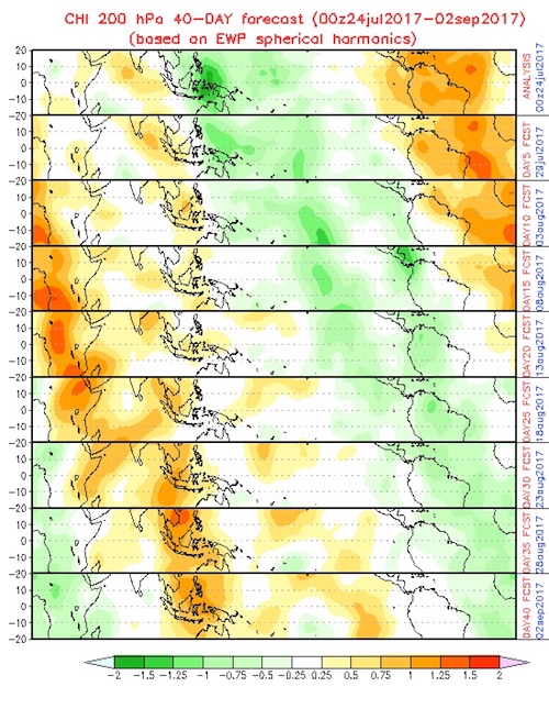
| Figure 3. A model-generated forecast, extending in five-day increments from July 24 to September 2, of where upward and downward motion across the tropics at the 200-mb level (about 39,000 feet) is expected to predominate. The forecast is based on a simple technique of propagating wavelike atmospheric features related to the Madden-Julian Oscillation eastward over time. Over the Atlantic tropics, sinking air (warm colors), which now predominates, is predicted to be replaced by a tendency toward rising air during August, which would be more favorable for the development of tropical cyclones. Image credit: NOAA/NWS Climate Prediction Center, via CPC’s MJO website. |
It’s been five days since Tropical Storm Don dissipated near the Windward Islands, and it looks like it will be at least another five days before the tropical Atlantic sees another system with the potential to develop into a tropical depression, according to the 2 pm Monday Tropical Weather Outlook from the National Hurricane Center (NHC).
The 0Z Monday runs of the GFS and European model ensembles predict that the next potential for Atlantic tropical cyclone development will occur in the Friday – Sunday time frame, from a tropical wave that will be midway between the Lesser Antilles Islands and coast of Africa.
The Madden-Julian Oscillation (MJO), a pattern of increased thunderstorm activity near the Equator that moves around the globe in 30 - 60 days, and which can increase the odds of tropical cyclone formation when it is strong and located in the proper location, is currently weak and in an unfavorable location, and will not favor tropical cyclone formation in the Atlantic over the coming week. However, the MJO is predicted to intensify in August, as it moves into a location that would be more supportive of tropical cyclones downstream in the Atlantic.
The Saharan Air Layer (SAL), which can infiltrate and weaken tropical waves moving across the Atlantic, typically weakens and shifts as we approach late summer, and sea-surface temperatures should be continuing to warm toward their seasonal peak, so it appears multiple factors are coming together for a potentially active August in the Atlantic.
African dust reaches Texas
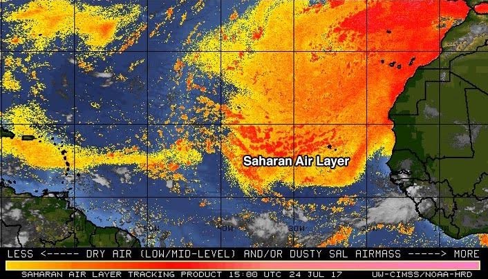
Dry air from an upper level low pressure system and the Saharan Air Layer (SAL) rules the Atlantic, which is typical for July. In fact, dry air and dust from the SAL arrived in Texas on Monday, where the dust is causing poor visibility and health concerns for sensitive groups, according to abc13.com in Houston.
 |
| Figure 4. The Saharan Air Layer (SAL) analysis from 11 am EDT Monday, July 24, 2017, showed a large area of dry Saharan air in the tropical Atlantic. Image credit: University of Wisconsin CIMSS/NOAA Hurricane Research Division. |
The Texas Commission on Environmental Quality expects levels of fine particles (PM2.5) from the African dust cloud to affect all of Texas (except western parts) on Monday, with light amounts of dust spreading into West Texas on Tuesday. PM2.5 levels from the dust from the episode are mostly expected to be below the federal standard in Texas, in the “Moderate” range, with possibly higher levels in the Corpus Christi area. Thanks go to Cat 6 commentor “PARTY TIME! ✓ᵛᵉʳᶦᶠᶦᵉᵈinsane” for this stat. By Wednesday, the SAL outbreak should die down over Texas.
We'll have our next update no later than Wednesday.
Dr. Jeff Masters co-authored this post.


