| Above: GOES-16 infrared image of Tropical Storm Franklin along the west coast of the Yucatan Peninsula as of 2335Z (7:35 pm EDT) Tuesday, August 8, 2017. Image credit: NASA/MSFC Earth Science Branch. |
Tropical Storm Franklin embarked on the next phase of its life on Tuesday evening as it moved off the west coast of Mexico’s Yucatan Peninsula into the Bay of Campeche. As of 8:00 pm EDT Tuesday, the center of Franklin was about 60 miles northwest of Campeche, heading west-northwest at 12 mph. Top sustained winds had bottomed out at 40 mph, but Franklin is predicted to re-intensify as it moves across the Bay of Campeche toward the northeast Mexico coast south of Tampico. There, Franklin will make its second landfall on Thursday, most likely as a strong tropical storm—but it could become the Atlantic’s first hurricane of the year shortly before landfall. Update: A hurricane warning was issued late Tuesday night for the Mexican coast from Puerto de Veracruz to Tuxcan, and Franklin's top winds increased to 50 mph as of 11 pm EDT.
Franklin struck the east coast of the Yucatan Peninsula near Pulticub, Mexico, at around 10:45 pm EDT Monday with top sustained winds of 60 mph. Impacts were minimal, as Franklin’s strongest winds hit a sparsely populated area and its shield of showers and thunderstorms (convection) arrived in a fragmented state. A NOAA buoy reported gusts to 47 mph more than 200 miles east-northeast of Franklin's center early Tuesday morning. Heavy rainbands persisted along the eastern Yucatan coast long after the passage of Franklin’s core. Cozumel reported 11.95” of rain from Monday through late Tuesday, with a peak wind gust to 32 mph on Tuesday morning.
 |
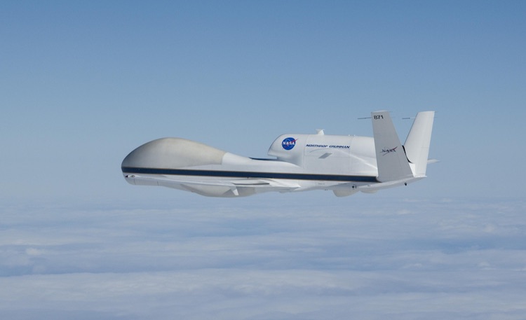
| Figure 1. NASA’s remotely piloted Global Hawk aircraft can gather large amounts of data in and near hurricanes by depositing dropsondes (parachute-borne instrument packages) from high altitudes. Image credit: NASA. |
Research aircraft have a date with Franklin
Two research aircraft set out on Tuesday afternoon for evening flights to sample the environment in and around Franklin. A team from NOAA’s Atlantic Oceanographic & Meteorological Laboratory (NOAA/AOML) headed out from Lakeland, FL, aboard a NOAA P-3 aircraft on its first hurricane research flight of 2017. Also on track to sample Franklin late Tuesday into Wednesday was a remotely piloted NASA Global Hawk aircraft. If all goes well, the Global Hawk will release close to 100 dropsondes from high altitudes into and near Franklin over a 23-hour mission.
These two research flights will supplement ongoing reconnaissance flights into Franklin every six hours, helmed by NOAA and Air Force Hurricane Hunters.
| Figure 2. WU depiction of NHC tracking map for Franklin as of 21Z (5:00 pm EDT) Tuesday, August 8, 2017. |
Outlook for Franklin
The forecast for the remainder of Franklin’s life as a tropical cyclone is fairly straightforward. Models are in close agreement on a leftward-arcing, generally westward track that will take the storm into the east coast of central Mexico early Thursday.
Franklin is expected to intensify over warm waters, with an ample supply of atmospheric moisture. The amount of strengthening will be limited mainly by the amount of time Franklin will spend over the Bay of Campeche (about 48 hours) and by northerly wind shear that will push above 10 knots by Wednesday morning, as evident in the 18Z Tuesday SHIPS model output. If the shear stays weaker than expected, Franklin could surge to at least Category 1 hurricane strength before landfall. In fact, the 18Z Tuesday run of the HWRF high-resolution hurricane model—our most reliable intensity guidance—came in stronger than the last several runs, indicating Franklin could attain Category 2 strength just before reaching the Mexican coast.
The Mexican government has issued a hurricane watch and tropical storm warning ahead of Franklin along the east coast of Mexico from Rio Panuco south to Puerto de Veracruz. A tropical storm watch extends from Puerto de Veracruz along the south coast of the Bay of Campeche to Sabancuy. Torrential rains—locally 15” or more—are liable to be the biggest threat from Franklin, especially as the storm moves inland and encounters the rugged terrain of central Mexico. Laggard rainbands southeast of Franklin could dump a few more inches of rain Tuesday night into Wednesday on parts of Belize and northern Guatemala as well as the Yucatan Peninsula.
 |
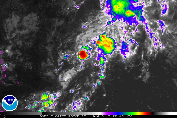
| Figure 3. Enhanced infrared satellite image of Invest 99L in the central Atlantic as of 2245Z (6:45 pm EDT) Tuesday, August 8, 2017. Image credit: NOAA/NESDIS. |
Models can’t make up their minds on future of Invest 99L
Our leading global models have been waffling on the destiny of tenacious Invest 99L, a wave now traversing the western part of the deep tropical Atlantic about 650 miles east of the Leeward Islands. Early on, the GFS model and its ensemble runs favored a potential East Coast threat from 99L next week, while the European operational and ensemble runs ran cold on the idea. By Tuesday afternoon, the tables had turned. None of the GFS ensemble runs from 12Z Tuesday developed 99L beyond cursory fashion, nor did the operational runs of the UKMET and GFS models. Meanwhile, the European operational run and nearly all of the Euro ensemble runs from 12Z Tuesday produced at least a tropical depression. Several of those Euro runs generated a hurricane that moves uncomfortably close to the southeast U.S. coast.
A number of members from the 12Z ECMWF EPS run bring Invest #99L to a Category 2 Hurricane (red dots) off the eastern seaboard next week. pic.twitter.com/hk4piv7WbD
— Michael Ventrice (@MJVentrice) August 8, 2017
Convection has been coming and going with 99L, much of it shearing to the northeast and never quite consolidating into a persistent core. In spite of relentlessly dry air and moderate wind shear, the wave has persisted, and it could yet gather strength once it moves into a zone with lesser wind shear near or just north of the Lesser Antilles late this week. About 75% of the 12Z Tuesday ensemble members from the Euro model bring 99L east of the Bahamas as a tropical storm by Saturday. At that point, wind shear is projected by the 18Z Tuesday SHIPS model run to drop below 10 knots, and sea surface temperatures will be around 29°C (84°F), about 1°C above average for this time of year. Dry air may continue to be an issue unless 99L can carve out a protective “pouch” of moisture and stave off the dryness.
If it does manage to develop, 99L will be steered by a large and strong Atlantic ridge extending west toward the mid-Atlantic coast. The predicted shape of the ridge, and the projected approach of a strong upper-level trough across the Northeast U.S., suggests that any U.S. threat from 99L is more likely to be along the Southeast coast rather than from Virginia northward. The picture could easily change this far out, though—especially given the models’ recent flip-flopping—and we have plenty of time to monitor the situation. In its 8:00 pm Tuesday tropical weather outlook, the NOAA/NWS National Hurricane Center gave 99L a near-zero chance of developing into at least a tropical depression by Thursday night, but a 40% chance by Sunday night, up from 30% in the prior outlook.


