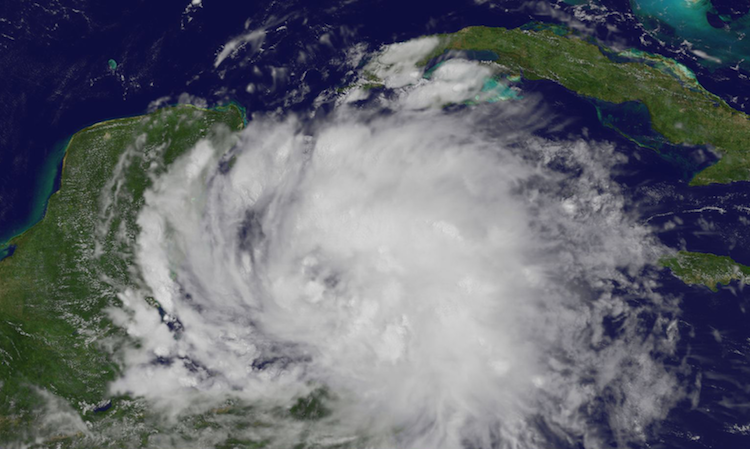
| Above: GOES-16 water-vapor satellite image of Tropical Storm Franklin as of 0800Z (4:00 am EDT) Tuesday, August 8, 2017. GOES-16 imagery is preliminary and non-operational. Image credit: NASA/MSFC Earth Science Branch. |
Tropical Storm Franklin was rolling across the Yucatan Peninsula early Tuesday after crashing ashore near Pulticub, Mexico, at around 10:45 pm EDT Monday. Franklin made landfall with top sustained winds of 60 mph. As of 5:00 am EDT Tuesday, Franklin was located just inland, about 55 miles north-northwest of Chetumal, over a sparsely populated section of Mexico’s Quintana Roo state. A NOAA buoy reported gusts to 47 mph more than 200 miles east-northeast of Franklin's center early Tuesday morning. Well to the north of Franklin, Cozumel reported 3.80” of rain on Monday, but top winds at Cozumel had reached only 23 mph as of 4 am EDT Tuesday. Winds and rainfall were even lighter at Chetumal, on Franklin’s much-weaker south side.
Franklin took advantage of highly favorable conditions east of the Yucatan on Monday to become a well-structured tropical storm, with excellent outflow evident on satellite imagery. However, the showers and thunderstorms (convection) surrounding Franklin’s center were not as intense as they could have been, and the storm’s center was large and somewhat diffuse. These factors may be what kept Franklin from quickly become a hurricane before landfall—good news for residents and visitors along the Yucatan coast!
As of early Tuesday, Franklin’s shield of convection had become more fragmented and notably less impressive as the storm worked its way inland. However, the core of the storm had become more organized, with a closed eye evident on radar. This new organization may work in Franklin's favor once the storm moves off the west side of the Yucatan peninsula. Tropical storm warnings remained in effect Tuesday morning on both sides of the peninsula.
 |
| Figure 1. Radar display from the Philip Goldson Airport at Belize City, Belize, at 0501Z (1:00 am EDT) Tuesday, August 8, 2017, a little more than two hours after Franklin made landfall north of Belize. Image credit: National Meteorological Service of Belize. |
 |
| Figure 2. GOES-E visible-light satellite image of Tropical Storm Franklin at 1600Z (noon EDT) Monday, August 7, 2017, as Franklin was intensifying north of Honduras. Image credit: NASA-NOAA GOES Project. |
| Figure 3. WU depiction of NHC forecast for Tropical Storm Franklin issued at 5 am EDT Tuesday, August 8, 2017. |
Outlook for Franklin
Franklin's top winds are expected to gradually weaken over land before the center moves off the west coast of the Yucatan peninsula on Tuesday afternoon. At that point, Franklin will be a minimal tropical storm, perhaps even a tropical depression. The storm is predicted to get a second lease on life over the warm waters and supportive geography of the Bay of Campeche. In its forecast from 5:00 am EDT Tuesday, the NOAA/NHC National Hurricane Center predicted that Franklin would approach hurricane strength before making its second landfall early Thursday, expected to occur on the northeast Mexican coast north of Tampico. Models are in close agreement on this west-northwest track, though with some differences on how far north or south landfall will occur.
Given how weak Franklin is expected to be when it enters the bay, it is now unlikely that the storm will be able to rapidly intensify beyond Category 1 strength before it makes landfall, especially with moderate wind shear now expected. The HWRF model, our most reliable for intensity predictions, has pulled back on its projected strength. In its 00Z Tuesday run, HWRF called for Franklin to be near or just above minimal hurricane strength at landfall, and this appears to be a reasonable outlook, not far from the NHC forecast. A hurricane watch was in effect Tuesday morning on the northeast Mexican coast from Sabancuy to Puerto de Veracruz. Torrential rains and a mudslide risk may take shape across parts of central and northeast Mexico after Franklin's second landfall, as the storm's convective shield is likely to expand and consolidate by that point.
We’ll have more on Franklin and other tropical developments in an update on Tuesday afternoon.


