| Above: Infrared satellite image of Cyclone Mekunu taken at 2 am EDT (6Z) May 24, 2018. At the time, Mekunu was a high-end Category 1 storm with 90 mph winds. Image credit: U.S. Naval Research Laboratory. |
Intensifying Cyclone Mekunu, which was an upper-end Category 1/low-end Category 2 storm with 90 - 95 mph winds at 2 am EDT Thursday (10 am local time), according to the Joint Typhoon Warning Center (JTWC) and the India Meteorological Department (IMD), is on its way to becoming one of the strongest tropical cyclones on record to strike the Arabian Peninsula in modern recordkeeping. Mekunu is expected to make landfall as a Category 1 or Category 2 storm on Friday night (local time) in far southwestern Oman, close to the Yemen-Oman border. Update: As of 8 pm EDT Thursday (4 am Friday local time), Mekunu's top winds had increased to 100 mph, putting it solidly in the Category 2 range.
Only a small number of hurricane-strength cyclones have been recorded on the Arabian Peninsula in data going back to the 1970s. Mekunu is especially concerning for two reasons:
—it will be striking the coast at a close-to-perpendicular angle, which will maximize the impact of its winds, waves, and surge along the coast of Oman.
—it is predicted to make landfall near or just west of the city of Salalah, Oman (metro population 340,000), which greatly raises the potential for damage and disruption from high winds and flooding.
Mekunu was a well-organized system on Thursday morning, as seen on satellite imagery, with excellent outflow at high levels. Some dry air was being entrained into the northeastern part of the storm, where showers and thunderstorms were less extensive, but the core of the storm appeared to be maintaining itself. An eye-like feature was becoming apparent Thursday morning on infrared satellite imagery. The outer spiral bands of the cyclone were already spreading heavy rains over coastal Yemen and Oman on Thursday morning.
 |
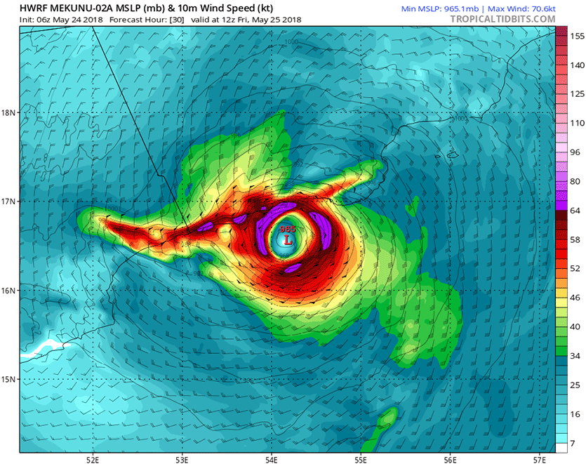
Figure 1. Predicted wind speed (knots) for Mekunu at 12Z Friday, May 25, 2018 (4 pm local time), as predicted by the 6Z Thursday, May 24, 2018 run of the HWRF model. This forecast has Mekunu making landfall near Salalah, Oman at 7 pm Friday night local time as a Category 1 hurricane with 85 mph winds and a central pressure of 966 mb. Purple colors correspond to Category 1 hurricane strength (64 knots and greater). Image credit: Levi Cowan, tropicaltidbits.com. |
The forecast for Mekunu
Mekunu is passing over very warm sea-surface temperatures of 30-32°C (86-90°F), which will favor intensification on Thursday. Warm waters extended to great depth along the path of the storm, giving Mekunu a tropical cyclone heat potential in excess of 100 kilojoules per square centimeter—the kind of heat content often seen leading to rapid intensification. Wind shear is expected to remain moderate, around 15 knots. The main upper bound on strengthening will be an increasing intrusion of dry air as Mekunu nears the Arabian Peninsula.
There is high confidence on Mekunu maintaining its present course, with a slight bend toward the northwest expected as the cyclone approaches the coast on Friday. In forecasts issued late Wednesday night, both the India Meteorological Organization and the Joint Typhoon Warning Center (JTWC) predicted that Mekunu would reach the coast just west of Salalah around 0Z Saturday (4 am Saturday local time) as a Category 1 or Category 2-equivalent cyclone.
Model guidance remains a few hours faster than the outlook from operational agencies. The 6Z Thursday run of the HWRF model brings Mekunu into the coast near or just west of Salalah around 15Z Friday (7 pm local time) as a Category 1 storm. The 6Z run of the GFS is in close agreement with the HWRF on a Category 1 landfall slightly farther west, between Salalah and the Yemen-Oman border. The GFS is also somewhat slower than the HWRF, with landfall projected around 18Z Friday (10 pm local time).
 |
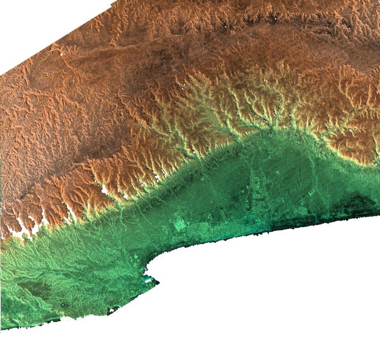
| Figure 2. This archived NASA satellite image, collected in 2000 from the Shuttle Radar Topography Mission, depicts the region around Salalah. The city lies along a broad coastal plain in far southwest Oman. Less than 15 km (9 mi) north of the city are the Qara Mountains, with peaks ranging as high as 1500 m (4900 ft). Image credit: NASA, via archive.org. |
Destructive flooding, significant storm surge a threat for southern Oman
Salalah, the largest urban area in southern Oman, is a major port city and tourist destination. Coastal fog is frequent during the summer monsoon, which turns the coastal plain and nearby mountainsides a lush, appealing green despite the fact that Salalah receives just five inches of rain per year on average. The region could easily see double that amount of rain from Mekunu, leading to potentially devastating flash flooding.
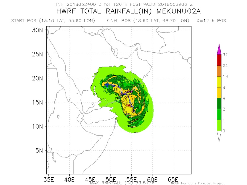
The 0Z Thursday run of the HWRF model (Figure 3) predicted a swath of 8–16” of rain would fall along a 150 mile-long section of the coastal plain of far northern Yemen and southern Oman, with localized totals of 16–24” or more possible over the mountainous terrain just inland. The high-altitude rains will be especially heavy near and just east of Mekunu’s center, where moisture-laden winds will plow directly into the Qara Mountains and get forced upward. Torrential runoff can be expected from these hillsides onto the coastal plain.
 |
| Figure 3. Predicted rainfall along the path of Tropical Cyclone Mekunu, as predicted by the 0Z Thursday run of the HWRF model. Image credit: NOAA/NCEP. |
Waves of up to 7.3 meters (24 feet) are pushing toward the coast of southern Oman, and these waves will occur atop a storm surge just to the east of where Mekunu makes landfall. “The significant wave height leads me to think coastal flood potential is a real threat,” said storm surge expert Dr. Hal Needham. “At some point the water from waves crashing onshore does not have time to drain before the next wave hits. My gut feeling is that we could see a noticeable storm surge that is quite dynamic, with a lot of wave action and rapidly moving water. Expect wave heights to be tremendous.”
Tropical cyclone history in the northwest Arabian Sea
Tropical cyclones are most common in the Arabian Sea in spring and autumn, during the transition periods between the strong southwest flow of the summer monsoon and the strong northeast flow that predominates in winter. There are signs that pre-monsoon (springtime) Arabian Sea cyclones have gotten stronger in the last 20 years, as we discussed in a 2015 post..
The region saw two powerful tropical cyclones in November 2015. Cyclone Chapala came ashore on the south end of the Arabian Peninsula on November 4 as the first hurricane-strength cyclone ever recorded in Yemen. Just four days later, Cyclone Megh passed just north of Socotra Island east of Somalia with Category 3 winds of 110 mph, destroying hundreds of homes and killing at least 18 people.
Tropical cyclones often weaken as they approach Oman and ingest dry desert air from the Arabian Peninsula. However, Oman is not invulnerable to cyclone disasters, two of which have occurred in the last 11 years.
Cyclone Phet, June 2010: Phet came ashore in far eastern Oman as a strong Category 2 storm, with top winds of 110 mph, according to the Joint Typhoon Warning Center (JTWC). At least 24 deaths were reported in Oman, with 23 other fatalities occurring in India and Pakistan as Phet moved by in a much-weakened state. Phet left an estimated $780 million (2010 USD) in damage in Oman.
Cyclone Gonu, June 2007: Gonu peaked as a Category 5 equivalent before passing just offshore of the eastern tip of Oman as a Category 1 storm and going on to become the first tropical cyclone on record to make landfall in Iran. Gonu was the strongest cyclone ever recorded in the Arabian Sea; in Oman, it caused at least 50 deaths and wreaked at least $4.2 billion in damage (2007 USD). At Ras al-Hadd, on the eastern tip of Oman, Gonu produced a storm tide (storm surge + astronomical tide) of 5 meters (16.5 feet). The storm surge is the highest on record for the Arabian Peninsula, according to Needham.
Prior to Gonu, the last significant tropical cyclone to affect Oman was in 1890, when a storm hit the Gulf of Oman coast and Muscat, dumping 270 mm of rain (10.63”) killing 700 people. Lesser cyclones affected the area in 1945 and 1977.
Jeff Masters co-wrote this post.
We'll have an update on 90L in the Atlantic by 2 pm EDT.


