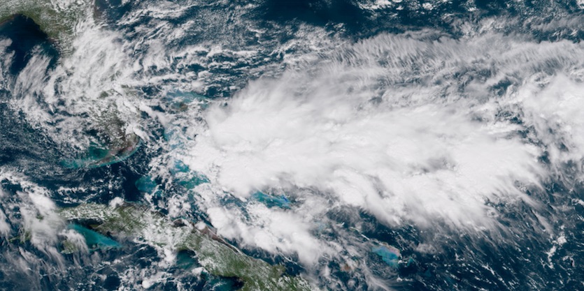
| Above: Infrared GOES-16 image of strong showers and thunderstorms over the southwestern Caribbean as of 12:30 pm EDT Tuesday, October 3, 2017. Tropical development may emerge in association with low pressure in this region later this week. Image credit: NASA/MSFC Earth Science Branch. GOES-16 images are considered preliminary and non-operational. |
For the third day in a row, the Atlantic had no named tropical cyclones on Tuesday. Such a statement wouldn’t seem unusual had it not been for the turbo-charged period from late August through September. This frenetic interval produced six hurricanes, including five major hurricanes and four that reached Category 4 or 5 strength. In Atlantic data going back to 1851, September set a record for the most amount of accumulated cyclone energy in any month—175, beating out 155 from September 1926—according to Phil Klotzbach (Colorado State University).
Klotzbach also reports these records set in September:
Number of named-storm days: 53.25 (old record 52.25, Sept. 2004)
Number of hurricane days: 40.25 (old record 34.50, Sept. 2006)
Number of major hurricane days: 18 (old record 17.25, Sept. 1961)
Each of these tallies includes the total number of days at each strength level for each storm of the month.
Light shear, toasty waters
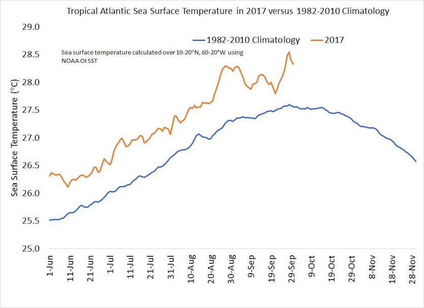
Why the avalanche of activity? For one thing, the entire tropical Atlantic has been unusually warm this year, in tandem with near-record warmth for the planet as a whole.
 |
| Figure 1. Sea surface temperatures across the tropical Atlantic, in gold, as compared to the 1981-2010 climatological average (blue). The tropical Atlantic is defined here as the region between 10°N and 20°N and between 60°W and 20°W. Image credit: Phil Klotzbach, Colorado State University. |
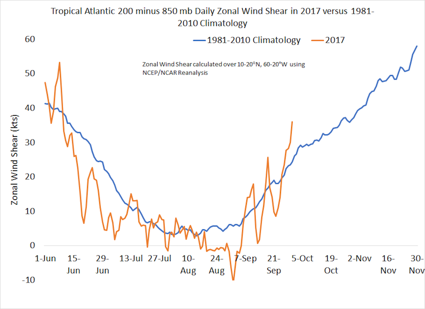
All this warm water serves as a convenient source of fuel for tropical cyclones, but the atmosphere must also be supportive. Light wind shear is one of the primary atmospheric ingredients needed to support hurricanes, and shear has been on the low side this year, especially during late August and September.
 |
| Figure 2. Daily wind shear across the tropical Atlantic (west-to-east wind component at 200 mb minus 850 mb), in gold, as compared to the 1981-2010 climatological average (blue). The tropical Atlantic is defined here as the region between 10°N and 20°N and between 60°N and 20°W. Image credit: Phil Klotzbach, Colorado State University. |
Watching the Caribbean and Gulf
As we move further into October, the most likely place for tropical development becomes the western Caribbean, where very warm waters extend well below the surface. This region is also far enough south to escape most of the hurricane-suppressing influence of early-autumn cold fronts and upper-level troughs. Surface pressures are gradually lowering over the southwestern Caribbean, and convection (shower and thunderstorm activity) has been increasing across the area (see image at top). This sprawling zone of lower pressure and widespread convection has some characteristics of what’s called a monsoon gyre. Centers of low pressure can spin off from these gyres to form tropical cyclones, but the process can be hard to predict.
 |
| Figure 3. Visible GOES-16 satellite image from 12:30 pm EDT Tuesday, October 3, 2017. Image credit: RAMMB / CIRA @ CSU. |
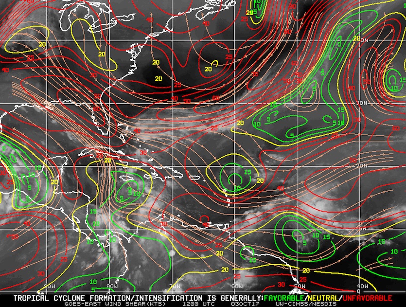
A tropical wave was moving across South Florida on Tuesday, with a zone of concentrated convection from The Bahamas toward Cuba and eastward along a stationary front (see Figure 3 above). The region was undergoing strong wind shear (see Figure 4 below) and the NOAA/NWS National Hurricane Center called for a near-zero chance of development in its tropical weather outlook issued at 8 am EDT Tuesday. A minority of ensemble members from the 00Z Tuesday runs of the European and GFS models develop a tropical depression with the convection north of Cuba on Wednesday or Thursday and move it northwestward across South Florida. Wind shear would continue to greatly limit the chance of development for any such system, but the overall pattern will reinforce a solid flow of moisture across the south Florida peninsula. The state’s southeast coast could rack up several inches of rain between now and Friday.
 |
| Figure 4. Strong wind shear of 20 – 50 mph (red contours) prevailed across Florida and The Bahamas at 8 am EDT Tuesday, October 3, 2017. The wind shear inhibits development of tropical cyclones. Image credit: UW-CIMSS/NESDIS. |
There’s a somewhat greater risk that a center of low pressure will spin off from the monsoonal gyre and head northward from the northwest Caribbean into the eastern Gulf of Mexico. Global models have been hinting at this possibility for days, and it’s a climatologically favored progression. In its 8 am EDT Tuesday outlook, NHC gave this system a near-zero chance of development through Thursday but a 30% chance through Sunday. Wind shear is predicted to relax over at least some parts of this area, so given the very warm ocean temperatures, we’ll need to keep an eye on it. Any system that emerges would tend to move toward the U.S. Gulf Coast late next weekend or early next week and could be a heavy-rain producer.


