| Above: Firefighters assess the scene as a house burns in the Napa wine region of California on October 9, 2017, as multiple wind-driven fires continue to ravage the area burning structures and causing widespread evacuations. Image credit: Josh Edelson/AFP/Getty Images. |
Hot, dry winds across the length of California triggered one of the most destructive and widespread fire days in state history on Monday. At least one person was killed, at least 60 were injured, and at least 1500 homes and other structures were lost by midday in nine Northern California counties, reported SFGate.com. The destruction puts Monday’s fires into the top five most damaging wildfire events in California history, according to Steve Bowen (Aon Benfield)
 |
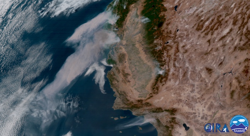
| Figure 1. GOES-16 visible satellite image from 2:15 pm PDT Monday, October 9, 2017, showing plumes from the Northern California fires (center) being blown westward (downslope) across parts of the northern Bay Area and into the Pacific. At bottom is a smaller plume from the Anaheim Hills fire southeast of Los Angeles. Image credit: RAMMB/CIRA @ CSU. GOES-16 images are considered preliminary and non-operational. |
Updated North SF Bay fire map from NOAA fire mapping products. pic.twitter.com/YT4K9lDi86
— Jan Null (@ggweather) October 9, 2017
The fires kicked off Sunday night as strong easterly winds (called “diablo” winds in Northern California, after Mt. Diablo) pushed hot, dry air across the California wine country. On Monday, the easterlies began to weaken in the Bay Area, while they intensified southward into the LA-San Diego area, where they’re known as Santa Ana winds (after the Santa Ana mountain range). By Monday afternoon, some 1000 homes were threatened in the Anaheim Hills neighborhood of eastern Anaheim, the Los Angeles Times reported.
As seen from Orange: A wildfire has erupted in Southern California's Anaheim Hills https://t.co/9oTKa6MRS9 pic.twitter.com/0Cbxghl95j
— Los Angeles Times (@latimes) October 9, 2017
“Emergency dispatch centers in the Bay Area were being overwhelmed by 911 calls,” said SFGate.com. “Officials urged people to only call 911 for active, unattended flames or life-threatening emergencies.” There was little to no containment of the largest fires at midday. Some 57,000 acres had burned by midday in Northern California, and an estimated 20,000-plus Californians have been forced to evacuate ahead of the flames. The evacuation zones include large parts of the city of Santa Rosa.
Fire devestation is insane in Santa Rosa. Untold number of homes and businesses destroyed. #santarosafire #tubbsfire #napafire #cnn pic.twitter.com/r4h5KW86Fo
— Dan Simon (@dansimoncnn) October 9, 2017
 |
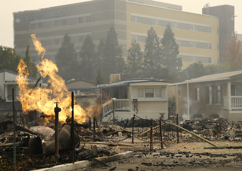
| Figure 2. Flame from an open gas valve burns at the Journey's End mobile home park on Monday, Oct. 9, 2017, in Santa Rosa, Calif. Wildfires whipped by powerful winds swept through Northern California, sending residents on a headlong flight to safety through smoke and flames as homes burned. Image credit: AP Photo/Ben Margot. |
 |
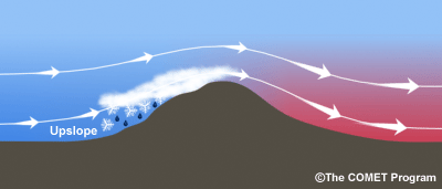
| Figure 2. A schematic showing winds forced upward against a mountain range, which produces cooling and can lead to rain or snow, followed by descent on the lee slope, which leads to compressional warming and lower relative humidity. Image credit: UCAR/COMET Program. |
Downslope winds in autumn a classic pattern for California fire
Many of the worst fires in and near the coastal ranges of California occur in early autumn. Of the ten most destructive California fires on record prior to this year, seven occurred in either September or October. The reason: proximity to the cool Pacific Ocean gives the region a Mediterranean climate, meaning that winters tend to be mild and wet and summers hot and dry. Last winter, the rain and mountain snows were far more generous than average, after years of drought. The moist winter fostered lush growth that later dried out in the intense heat of summer. Munich Re meteorologist Mark Bove tweeted that this year’s sequence was a “perfect setup for [a] bad California wildfire season.”
Strong fronts that sweep across the western U.S. in early fall often include a low-level dome of high pressure that pushes flow westward. Monday’s strong high was centered over the Rocky Mountains, where heavy autumn snows have pummeled the Colorado Front Range. As the winds around this high flowed over California’s coastal mountains and down the west slopes, the air heated up and the relative humidity dropped. Winds gusted as high as 75 mph on Monday atop South Mountain, above the town of Santa Paula in Ventura County. In Santa Ana, CA, the temperature at 2 pm PDT Monday was 87°F, with a relative humidity of 8%.
The pressure contrast driving the strong winds will decrease from north to south on Monday night, and a cooler-than-average air mass will sweep into the region from Tuesday through the rest of the week. Both of these trends will be a great boon to the ongoing firefighting efforts, although much damage has already been done and the disaster was still unfolding at midday Monday.
 |
| Figure 3. The Air Quality Index was in the “unhealthy” range (red) across parts of the San Francisco and Los Angeles areas at noon PDT Monday, October 9, 2017. Image credit: EPA/AirNOW. |
Dangerous air quality in parts of Bay Area, SoCal
Smoke and soot from the fires blew across the Bay Area in the pre-dawn hours, leading to a reddened sunrise and degraded air quality in San Francisco and nearby cities. By midday Monday, pockets of dangerous air quality were scattered in and near ongoing fires in both Northern and Southern California. A smoke advisory was issued by the Bay Area Air Quality Management District, advising residents to limit outdoor activities to avoid unnecessary exposure if smoke is smelled, and to set air conditioning units and car vent systems to re-circulate to prevent outside air from moving inside. The South Coast Air Quality Management District issued a more localized smoke advisory for parts of Orange and Riverside counties in connection with the Anaheim Hills fire.
Smoke from the ongoing fires will continue to pose local air quality issues as long as the fires rage. In the coming days, the smoke might have some impact on air quality further afield as it gets mixed into the large-scale flow from California eastward
We’ll be back with our next tropical update on Tuesday. Our Monday morning post covered newborn Tropical Storm Ophelia, which is gradually strengthening in the Central Atlantic, as well as the damage left by ex-Hurricane Nate.


