
| Above: Los Fresnos was among the areas in the Lower Rio Grande Valley of Texas inundated by several days of heavy rain on June 18-21, 2018. Image credit: NWS/Brownsville-Rio Grande Valley. |
For the third time in four years, the contiguous U.S. saw one of its warmest Junes in more than a century of recordkeeping, as reported by NOAA on Monday. June 2018 came in at third place among all Junes going back to 1895, behind the warmest (2016) and second warmest (2015). June came on the heels of the nation’s warmest May on record, which pushed the May-June period to a record high of its own.
Like butter on hot toast, the warmth in June oozed across most of the 48 states, with the Northeast as the main exception (see Figure 1). It was a top-ten warmest June for Texas as well as the Four Corners states of Arizona, Colorado, New Mexico, and Utah. There were plenty of hot days, but unusually warm nights were the true hallmark of last month. A dozen locations from Arizona to Michigan set or tied all-time records for their warmest low temperature on any date (and more such records were set in the first week of July). Last month’s average daily low was the warmest on record for any June in Iowa, Texas, and New Mexico.
 |
| Figure 1. Statewide rankings for average temperature for June 2018, as compared to each June since records began in 1895. Darker shades of red indicate higher rankings for heat, with 1 denoting the coldest month on record and 124 the warmest. Image credit: NOAA/NCEI. |
A wet corridor from the Northern Plains to the mid-Atlantic
As is often the case in early summer, June’s rainfall played out largely in the form of huge thunderstorm clusters (mesoscale convective systems, or MCSs) that plowed from the Great Plains into the Midwest. Conditions were wetter than average along a corridor from Montana and Wyoming to the mid-Atlantic; Iowa saw its tenth wettest June on record. Meanwhile, it was on the dry side across most of the southern tier of states, and exceptionally dry over the Great Basin, where Utah had its sixth driest June on record.
 |
| Figure 2. Statewide rankings for average precipitation for June 2018, as compared to each June since records began in 1895. Darker shades of green indicate higher rankings for moisture, with 1 denoting the driest month on record and 124 the wettest. Image credit: NOAA/NCEI. |
Major flooding occurred in a swath from northern Wisconsin into the Upper Peninsula of Michigan, stoked by moisture from the remnants of Hurricane Bud in the Northeast Pacific. Dozens of sinkholes opened across upper Michigan as 3" to 7" of rain fell in short order. The city of Houghton was especially hard hit (see the summary from the NWS office in Marquette).
 |
| Figure 3. Dozens of sinkholes emerged in Upper Michigan following major flooding on June 15-17, 2018. This one is on Cemetery Road in the Houghton area. Image credit: Richard Schreiner via NWS/Marquette. |
Torrential rains and flash floods put northern #Michigan into a state of disaster. The swollen rivers became conduits of sediment, bursting into Lake Superior. The red coloration is due to the iron-rich spodosols that dominate the Upper Peninsula: https://t.co/jbOtLzXIQG pic.twitter.com/jnQSP35K6b
— Joshua Stevens (@jscarto) June 20, 2018
Far from the large zone of heavy rain, a slow-moving tropical wave across Texas produced massive rainfall and flooding in the lower Rio Grande Valley (see photo at top) and in the Corpus Christi area, including areas hard-hit by landfalling Hurricane Harvey in 2017. As much as 20.65” of rainfall fell in a three-day period near Corpus Christi. Detailed reports on the June 2018 flooding have been posted by the NWS offices serving the Browsville/Rio Grande Valley and Corpus Christi areas.
 |
| Figure 4. This tornado spun over rural land northeast of Denver International Airport on June 19. Image credit: Bob Henson. |
June’s tornadoes: photogenic but non-deadly
Tornado activity tends to be on the low side during MCS-dominated patterns. This June, a number of dramatic twisters occurred in June to the west of their usual stomping grounds. Wyoming saw at least two tornadoes rated EF3, one near Gillette on June 1 and another north of Laramie on June 6. The last time Wyoming had seen an EF3-or-stronger tornado was in 1987. Another High Plains EF3 occurred in extreme eastern Montana and far northwest South Dakota on June 28, destroying a five-ton tractor and blowing its remnants from South Dakota several miles into Montana.
The most damaging tornado of the month, also an EF3, tore across the heart of Eureka in central Kansas on June 26. Doppler radar now provides ample warning of the tornado development process ahead of many twisters, but on occasion a tornado forms rapidly just before entering a town. Such was the case in Eureka, where eight people were injured, one critically. The tornado passed over a part of town struck by an EF2 tornado just two years earlier.
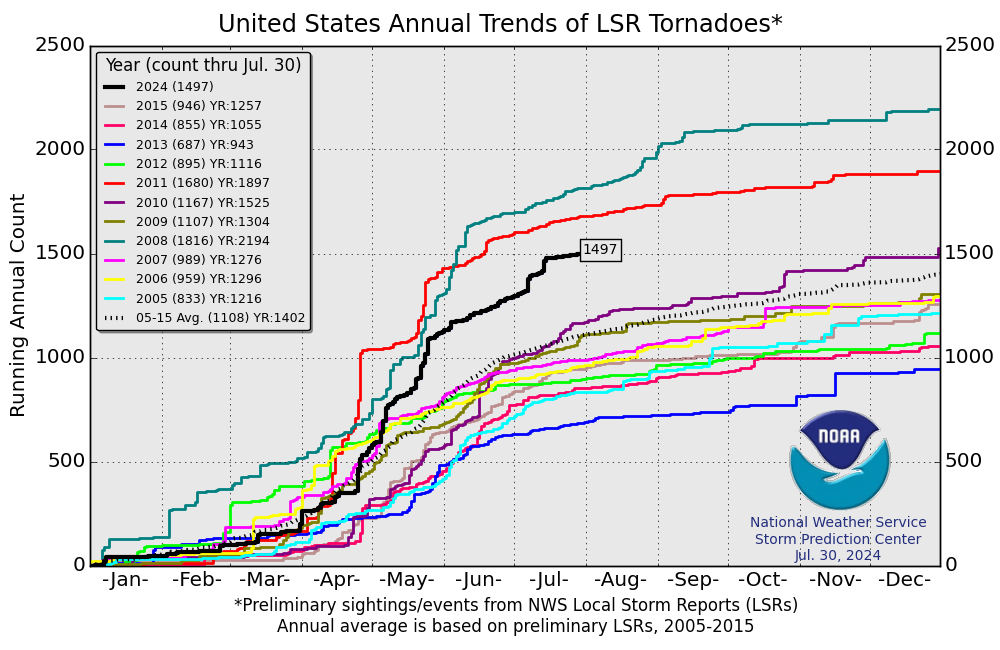
Happily, there were no U.S. deaths related to tornadoes in either May or June—the first time that’s happened in those two months since 2005 and only the second time in records going back to 1950, as noted by Brian Donegan at weather.com. Only 3 tornado-related deaths have occurred so far in 2018, and by June 27 the preliminary tornado count for the year was a mere 571, little more than half of the long-term average by that point.
We’ll have an update on intensifying Tropical Storm Chris on Tuesday morning.
 |
| Figure 5. Tornado reports compiled by the Storm Prediction Center for each year since 2005. The total of 571 for this year through June 27 was the lowest for that date among all of the years analyzed. Image credit: NOAA/NWS/SPC. |


