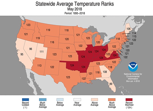
| Above: May 2018 eclipsed all previous Mays for warmth across the contiguous U.S. in records extending back to 1895. Image credit: Adapted from NOAA/NCEI. |
After one of the coldest Aprils in U.S. history, last month delivered a stunning switch—the warmest May for the contiguous U.S. in records going back to 1895. May came in at 5.21°F above the 20th-century average, which beats out the Dust Bowl month of May 1934 (4.51°F above the 20th-century average). This is the third time in the past three years that a longtime monthly U.S. heat record has been eclipsed: December 2015 toppled a 1939 record, and June 2016 pushed out June 1933.
May’s warmth was remarkably well-distributed around the country. Whereas the nationally chilly April (13th-coldest on record) still had above-average warmth over the western U.S., every one of the Lower 48 states came in well above average for May—a rare feat. A total of 41 states had a top-ten-warmest May, and eight of those states had a record-warm May: Arkansas, Illinois, Indiana, Kentucky, Missouri, Ohio, Oklahoma, and Virginia. The Oklahoma record is especially impressive given that western Oklahoma was near the epicenter of the devastating 1930s Dust Bowl.
 |
| Figure 1. Statewide rankings for average temperature for May 2018, as compared to each May since records began in 1895. Darker shades of red indicate higher rankings for heat, with 1 denoting the coldest month on record and 124 the warmest. Image credit: NOAA/NCEI. |
 |
| Figure 2. Much of the central and eastern U.S. underwent drastic swings from one of the coldest Aprils on record to one of the warmest Mays, compressing three to fourth months’ worth of normal temperature transition into a much shorter period. Image credit: weather.com. |
Winter-weary residents of the Upper Midwest found themselves undergoing weather whiplash by Memorial Day weekend. Minneapolis had its earliest-ever 100°F reading on Sunday, May 27, and the Twin Cities also hit 90°F on six consecutive days, beating the May record string of four days, as reported by weather.com in a roundup of late May’s heat. Even heat-hardy Texans found themselves sweating a bit ahead of schedule. Lubbock not only endured its hottest May on record but reached the 100°F mark on eight days, beating the old May record of six days.
Dozens of other U.S. cities and towns had their warmest May on record. This includes at least 11 state capitals, all with more than a century of weather data under their belts:
Austin, TX (80.6°F, tied with May 1996, records begin 1898)
Atlanta, GA (74.8°F, tied with May 1996, records begin 1880)
Charleston, WV (72.0°F, old record 71.7°F in 1991, records begin 1892)
Columbus, OH (71.7°F, old record 70.8°F in 1991, records begin 1879)
Indianapolis, IN (72.6°F, old record 70.7°F in 1896, records begin 1871)
Lansing, MI (64.7°F, tied with May 1881, records begin 1863)
Little Rock, AR (76.4°F, old record 76.3°F in 1987, records begin 1880)
Raleigh, NC (74.2°F, old records 73.9°F in 1896, records begin 1887)
Richmond, VA (73.4°F, old record 73.0°F in 2004, records begin 1897)
Springfield, IL (74.5°F, old record 72.3°F in 1962, records begin 1880)
Topeka, KS (74.7°F, old record 72.7°F, records begin 1888)
There’s no official weather station in Kentucky’s small capital city, Frankfurt, but nearby Lexington scored its warmest May (72.8°F, old record 71.6°F in 1962, records begin 1873).
 |
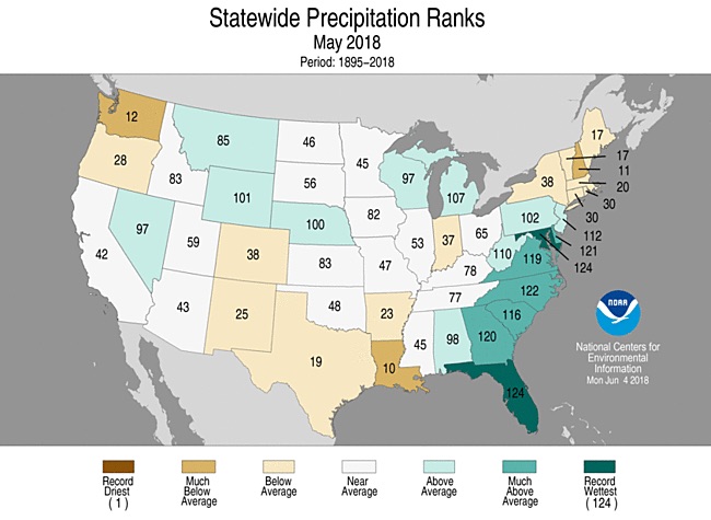
| Figure 5. Statewide rankings for average precipitation for May 2018, as compared to each May since records began in 1895. Darker shades of green indicate higher rankings for moisture, with 1 denoting the driest month on record and 124 the wettest. Image credit: NOAA/NCEI. |
A month of precipitation contrasts
Averaged across the contiguous U.S., precipitation was much less extreme than temperature in May. The month came in as the nation’s 55th-wettest in the 124-year NOAA database. There were some stark regional differences, though, led by the very wet conditions across the Southeast. The persistent moisture was fed by a low-level conveyor belt that brought near-record levels of moisture from the tropical Atlantic across the region, especially as Subtropical Depression Alberto moved across the eastern Gulf of Mexico.
Each of the Atlantic Coast states from Florida to Delaware had a top-ten-wettest May, and Florida saw its wettest May on record. As noted by Capital Weather Gang, Washington, D.C., slogged through a record seven consecutive days (May 13-19) with at least 0.25” of rain on each, racking up a total of 5.99” for that weeklong period.
Meanwhile, several pockets of dryness were scattered around the nation, including New England, the Pacific Northwest, and the Southern Plains. Louisiana had its 10th-driest May. A swath of extreme to exceptional drought conditions held firm through the month from parts of the Desert Southwest to western Oklahoma.
May’s most dramatic U.S. flood occurred in Ellicott City, MD, whose downtown was ravaged by flash flooding on Sunday, May 27, less than two years after a similary devastating event. A newly surfaced time lapse at weather.com shows the evolution of the May 27 flood along one of the city’s waterways in gripping detail.
 |
| Figure 4. This image made from video provided by DroneBase shows damage by floodwaters near the intersection of Ellicott Mills Drive and Main Street in Ellicott City, Maryland, on Monday, May 28, 2018, the day after flooding ravaged the area. Image credit: DroneBase via AP. |
From subtropical storm to tropical depression: the story of Alberto
In the weirdest precipitation event of May 2018, Subtropical Storm Alberto actually gained organization after it came ashore in far western Florida as the first named storm of the Atlantic season and moved toward the Great Lakes. Alberto was the second named storm this decade to strike U.S. shores over the Memorial Day weekend, just ahead of the official June 1 start of the Atlantic season, as noted in a weather.com recap. The storm dropped close to 10 inches of rain in parts of Alabama and produced landslides in North Carolina.
By the time it reached western Tennessee on the evening of May 29, Alberto was reclassified from a subtropical depression to a tropical depression by the NOAA/NWS Weather Prediction Center (which had taken the baton on this system from the National Hurricane Center). Alberto maintained its official status as a tropical depression as it crossed Indiana and Michigan on May 30, with clearly defined rainbands arcing around its center. One of those rainbands dumped 0.90” on Chicago’s O’Hare International Airport, pushing the city to its wettest May on record, with 8.21”. (The storms dumped close to 3” in other parts of Chicagoland; CoCoRaHS observer and fomer WU blogger Steve Gregory racked up 14.36” for the month in Schaumburg.) This isn’t the first tropical cyclone on record for Michigan: according to Dr. Jeff Masters, Dennis and Arlene in 2005 both made it into Michigan as tropical depressions, and there were others near the turn of the 20th century.
After spending two days over land and traveled more than 700 miles inland, #Alberto continues to maintain a compact and well-defined circulation with a symmetric rainbands spiraling around the center. pic.twitter.com/50AoBNXqFj
— NWS WPC (@NWSWPC) May 30, 2018
Alberto’s resilience can be chalked up mainly to an unusual lack of wind shear across the Corn Belt, together with the deep, rich moisture hauled inland by the depression. Wet soils can sometimes lead to a “brown ocean” effect that helps tropical cyclones to maintain or increase their strength after they moved inland. However, the ground across Illinois and Indiana was not particularly moist, according to Clark Evans (University of Wisconsin–Milwaukee), who studied the intensification of Tropical Storm Erin across a soggy Oklahoma landscape in 2007.


