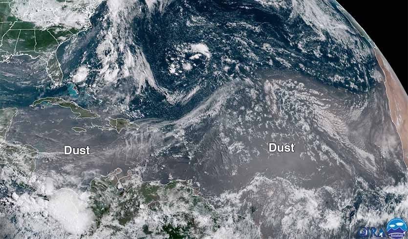
| Above: Dust from Africa was present over the much of the eastern tropical Atlantic and Caribbean Sea, as seen on July 22, 2018. Image credit: NOAA/RAMMB. |
The tropical Atlantic has been quiet since July 15, when the revived subtropical version of Tropical Storm Beryl died a quiet death in the chilly waters south of Newfoundland, Canada. No activity is expected this week, according to the latest 5-day tropical weather outlook issued at 8 pm EDT Sunday by the National Hurricane Center. The latest long-range runs of the GFS and European models show no tropical depressions developing in the Atlantic for the remainder of July, and odds are that we will have to wait until August to see Tropical Storm Debby form. Cool sea surface temperatures (SSTs), high levels of African dust/dry air, plus an unfavorable phase of the Madden-Julian Oscillation are the main causes of the pause in Atlantic tropical cyclone activity. High wind shear has also contributed.
 |
| Figure 1. Departure of sea surface temperature (SST) from average at 2 am EDT July 22, 2018. Most of the Main Development Region (MDR) for hurricanes had below-average temperatures. Image credit: Levi Cowan, tropicaltidbits.com. |
Cool SSTs
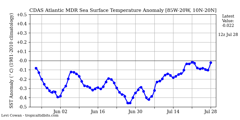
Sea surface temperatures (SSTs) in the Main Development Region for hurricanes, between 10° and 20°N, from the coast of Africa to the coast of Central America, remain cooler than average. On July 22, this departure from average was 0.5°C. These cool SSTs are largely due to a positive phase of the North Atlantic Oscillation (NAO) that we’ve been in since April. A positive NAO means that the Azores-Bermuda High is stronger than usual, and the winds circulating around it blow faster. The clockwise flow of air around the High brings strong east-to-west trade winds across the tropical Atlantic, which stir up the ocean, bringing cooler SSTs through evaporation and mixing of cooler water from below to the surface.
The latest NOAA NAO forecast calls for the NAO to remain positive into the first week of August, with a possible relaxation to near-average conditions during the second week of August. If the trade winds do finally relax during the 2nd week of August, it will still take several weeks for the SSTs to warm up to near-average levels. This means we can expect a delay in the start of the peak part of hurricane season. Typically, we see a big increase in Atlantic hurricane activity around August 15 – 20.
 |
| Figure 2. The Northwest Pacific was very active on July 22, as is commonly the case when the Madden Julian Oscillation (MJO) is located there. The Atlantic tends to be quiet in these situations. |
The MJO favors Western Pacific activity, but not Atlantic activity
The Madden Julian Oscillation (MJO), a pattern of increased thunderstorm activity near the Equator that moves around the globe in 30 - 60 days, is currently located in the Western Pacific Ocean, favoring typhoon development there. We tend to see the least Atlantic hurricane activity when the MJO is located in the Western Pacific. The MJO will steadily progress to the east over the next few weeks, though, and will be in a configuration more favorable for Atlantic hurricane activity by the 2nd week of August. However, it is uncertain how strong the MJO may be at that point. If it is weak, it may not have much effect on Atlantic hurricane activity.
 |
| Figure 3. Change in sea surface temperatures (SSTs) for the 7-day period ending at 8 am EDT July 22, 2018. A large cloud of African dust blocked enough sunlight to cool SSTs by more than 0.5°C, relative to average, over most of the tropical Atlantic and Caribbean (though stronger-than-average trade winds also contributed to this cooling in some areas). Image credit: Levi Cowan, tropicaltidbits.com. |
African dust
An unusually concentrated plume of African dust has spread across the tropical Atlantic and into the Caribbean over the past two weeks. The dust blocked enough sunlight to cool SSTs by more than 0.5°C, relative to average, over most of the tropical Atlantic and Caribbean during this period (though stronger-than-average trade winds contributed, as well). Forecasts from NASA’s GMAO model show fairly typical dust levels over the tropical Atlantic during the remainder of this week, with a potential new surge of dust coming this weekend. June and July are typically the most active months for transport of African dust across the Atlantic. See my African dust tutorial for more detail.
The African dust arrived in Texas early last week, bringing high levels of fine particulate pollution (PM2.5, particles less than 2.5 microns or 0.0001 inch in diameter). The dust, in combination with human-generated pollution, brought the highest PM2.5 levels of the year to six of the 37 monitoring locations in Texas on July 16 and 17; three monitoring stations in the Dallas/Ft. Worth area violated the 24-hour PM2.5 standard of 35 μg/m3, with an air quality index (AQI) in the “Unhealthy For Sensitive Groups” (orange) range. This is the second African dust episode of the summer to bring bad air quality to Texas (the other occurred on July 1). It is very unusual to see two such intense African dust episodes in Texas in one month.
For the first time in over 730 days, our Atmospheric ENSO index has risen to positive values (El Nino atmospheric forcing) pic.twitter.com/aiGuNrUQM9
— Michael Ventrice (@MJVentrice) July 20, 2018
El Niño-like levels of wind shear not present yet
Wind shear has been near-average to above-average over most of the tropical Atlantic over the past week, and is predicted to remain that way during the coming two weeks. It does not appear that our slow progression towards El Niño has brought El Niño-like very high wind shear to the tropical Atlantic yet (though the atmosphere does appear to be starting to respond in an El Niño-like fashion—see Mike Ventrice’s tweet above). NOAA’s Climate Prediction Center (CPC) continued an El Niño Watch in their July 12 monthly advisory. Over the past week, sea surface temperatures (SSTs) in the benchmark Niño 3.4 region (in the equatorial Pacific) were about 0.2°C above average--below the 0.5°C above average threshold needed to be classified as a weak El Niño.


