| Above: Infrared image of Potential Tropical Cyclone 2 organizing in the Gulf of Mexico at 2146Z (5:46 pm EDT) Wednesday, July 10, 2019. Image credit: tropicaltidbits.com. |
Developing Potential Tropical Cyclone 2 (PTC 2) in the Gulf of Mexico is predicted to bring a storm surge of 3 - 6 feet to Southeast Louisiana, which New Orleans’ improved levee system would ordinarily be able to handle with ease. However, these are not ordinary times. The Mississippi River is near flood stage, with the waters of the river lapping just four feet below the lowest point in the levee system protecting the city. If PTC 2 intensifies into Hurricane Barry as forecast, the storm surge from Barry has the potential to move up the Mississippi River and come close to overtopping the lowest points in New Orleans’ levee system. If Barry grows stronger than forecast and takes a track closer to New Orleans than currently forecast, the potential for serious storm surge flooding of New Orleans exists.
 |
| Figure 1. Current and predicted water levels at the Carrollton gage on the Mississippi River in New Orleans on July 10, 2019. The river is currently at 16’ above sea level, and the city’s levees protect the city to a height of 20’. The storm surge from PTC 2 is predicted to reach that level on Saturday afternoon. The last time water levels this high were observed at this point on the Mississippi was in the Great Flood of 1927. Update: The predicted flood forecast was lowered from 20' to 19' as of Thursday morning, July 11. Image credit: NOAA. |
History of New Orleans’ upgraded levee system
In the wake of the unthinkable devastation wrought by Hurricane Katrina in New Orleans in 2005, Congress approved a $14.5 billion upgrade to the city's flood defenses—the Hurricane and Storm Damage Risk Reduction System (HSDRRS), a 139-mile system of levees, walls and gates designed to protect against a 1-in-100-year storm surge, equivalent to what a Category 3 hurricane would bring.
The new flood defense system already has undergone a stern test, thanks to Hurricane Isaac of 2012. Isaac was a large, slow-moving Category 1 storm with 80 mph winds that brought a storm surge characteristic of a Category 2 storm—ten feet—to New Orleans. The new flood defenses performed admirably, giving confidence that the city's new flood defenses can indeed withstand the fifteen-foot storm surge that a 1-in-100 year Category 3 hurricane might bring.
The Louisiana coastline has experienced 59 hurricane strikes since 1851 (including Isaac), but only one of these hurricanes brought a storm surge to New Orleans capable of overwhelming the new levee system--if it behaves as designed. That storm was the deadliest hurricane in Louisiana history, the 1893 Chenier Caminanda hurricane, which hit the coast south of New Orleans as a Category 4 storm. Over 2,000 people died in the storm, mostly due to storm surge.
 |
| Figure 2. The Gulf Intracoastal Waterway West Closure Complex, part of the $14.5 billion upgrade to New Orleans' flood defenses in the wake of Hurricane Katrina. |
New Orleans' Achilles heel: the Mississippi River levee system?
But the New Orleans levee system has an Achilles' heel, one that may make it vulnerable to a mere Category 1 hurricane storm surge. That weakness is the levees that protect the city from the Mississippi River. Although these levees lie more than 100 miles upriver from the Gulf of Mexico, hurricane storm surges from five storms over the past 50 years—Betsy (1965), Katrina (2005), Georges (1998), Isaac (2012), and Gustav (2008)—have pushed storms surges of seven feet or higher upriver to New Orleans.
According to a 2013 storm surge study using the ADCIRC model done by Notre Dame researcher Dr. Johannes Westerink and colleagues, these large surges can occur because strong sustained easterly winds push water into shallow Breton Sound, overtopping the river’s east bank south of Pointe la Hache, Louisiana. The surge then penetrates into the Mississippi River, and is confined by levees protecting Plaquemines Parrish on the west bank. These levees capture the surge, and force it upriver towards New Orleans. The main channel’s width and depth allow the surge to propagate rapidly and efficiently upriver.
Normally, these storm surges moving up the Mississippi River are not a concern for New Orleans, since hurricanes typically arrive in August, September, and October, when the river is at its lowest flow levels—more than 15' below the tops of the levees. But if any of these five hurricanes had occurred when the Mississippi River was in flood—when the river is just 3' below the tops of the levees in New Orleans--the storm surge coming up the river might have pushed water over the tops of the levees and into the below-sea level bowl that much of the city lies in. For example, Hurricane Katrina pushed the highest storm surge on record up the Mississippi River, reaching 13' in New Orleans. But since the river was only at a 3' water level prior to the hurricane, the surge stayed 4' below the tops of the levees.
 |
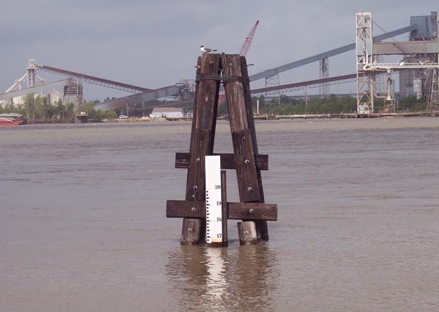
| Figure 3. Carrollton gage on the Mississippi River at New Orleans. Flood stage on the gage is at 17', which is 3' below the top of the city's levees. Image credit: USACE. |
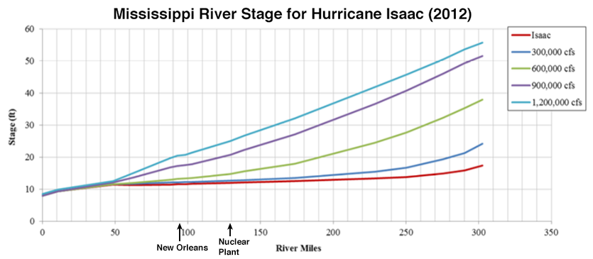
But it wouldn't take a Category 3 hurricane to flood New Orleans if the Mississippi River were at flood stage. A large, slow-moving storm like Hurricane Isaac of 2012 might be able to overwhelm New Orleans' flood defenses. During Hurricane Isaac, a storm surge estimated at 12' moved up the Mississippi in Plaquemines Parish, south of New Orleans.
Since salt water is more dense than fresh water, the surge traveled along the bottom of the river, with the fresh water flow of the river lying on top. The surge continued upriver, and before reaching New Orleans, encountered an underwater barrier in Plaquemines Parish. This barrier was constructed by the Army Corps of Engineers because of the summer drought of 2012, in order to keep salt water from moving upstream and contaminating the drinking water for New Orleans.
The barrier was able to completely block the flow of salt water upriver from Hurricane Isaac, and no salt water made it as far as New Orleans. However, the massive intrusion of ocean water into the river channel caused the mighty Mississippi's fresh water flow to back up for hundreds of miles. Water levels were elevated by 10' in New Orleans (103 miles upstream from the mouth of the Mississippi), 8' in Baton Rouge (228 miles upstream), and 1.4' at Knox Landing, an amazing 314 miles upstream.
If Isaac had hit when the Mississippi River was at flood stage, the surge could have overtopped the levees in New Orleans. Fortunately, the physics of the situation when the river has a high flow rate at flood stage means that a storm surge traveling upriver does not get as high as when the river is high. Thus, an 8-foot storm surge at New Orleans at low river flow rates might only be a 4-foot storm surge when the river was at flood stage.
I asked Dr. Westerink if a storm like Isaac could have overtopped the levees were it to hit when the Mississippi River were at flood stage. He responded that it was a very complicated situation, and it would depend upon how many levees downstream from New Orleans were overtopped as the storm surge propagated upriver, since that would allow the surge to spread out and not be as high when it reached New Orleans. In fact, if the surge were large enough, it could overtop the levees on the west bank of the river in Plaquemine Parrish, keeping that levee system from channeling the storm surge upriver towards New Orleans. For those interested, his 2013 paper is Surge Generation Mechanisms in the Lower Mississippi and Discharge Dependency.
 |
| Figure 4. Predicted height of the storm surge from Hurricane Isaac of 2012 for different flow rates of the Mississippi River as measured at Tarbert Landing. The figure is taken from a 1-D modeling study done as part of a 2014 Masters thesis by Tshering T. Gurung, and found that if Hurricane Isaac of 2012 had hit with the Mississippi River at flood stage, with a flow rate of 1,200,000 cfs (light blue line), the surge would have been near the tops of the levees (20') in New Orleans, and at a height of 25.5' (3' below the top of the levees) at the Waterford Nuclear Plant farther upriver. On July 10, 2019, the flow rate of the Mississippi River at Tarbert Landing was 1,220,000 cfs—virtually identical to the flow rate modeled here with the light blue line. Image credit: One-Dimensional Dynamic Modeling of the Lower Mississippi River, 2014 Masters thesis by Tshering T. Gurung. |
The risk of an early-season hurricane hitting during a Mississippi River flood
The U.S. just experienced its wettest 12-month period on record, ending in June, and the Lower Mississippi River has been at flood stage for the longest period on record. With the river currently just four feet below the tops of the levees in New Orleans at their lowest point, a slow-moving Category 1 hurricane like the predicted Hurricane Barry could potentially drive a storm surge capable of overtopping the river's levees. Note, though, that the “profile” option from the National Levee Database shows that most of New Orleans is protected to a height greater than 20’ along the Mississippi River level system, with levee heights ranging from 20 – 27’ above sea level. It is possible, too, that the Army Corps could construct temporary barriers on top of the levees at key vulnerable points.
On the other hand, according to a nola.com article by veteran New Orleans journalist Mark Schleifstein published Wednesday, "some levee segments along both the east and west banks could be as low as 18 feet." A companion article includes details on these levees, which are concentrated toward the east side of the city. Update: The U.S. Corps of Engineers stated on Thursday that the maps showing sub-20' levee heights in the New Orleans area are out of date and that river levees in New Orleans are at least 20' high, according to a follow-up noaa.com article published on Thursday.
 |
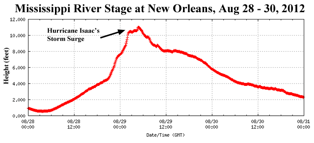
| Figure 5. Water level at the Carrollton gage on the Mississippi River at New Orleans during the passage of Hurricane Isaac in August 2012. Prior to Isaac's arrival the river was running just two feet above its record low. Isaac drove a storm surge of ten feet to New Orleans. Levees on the Mississippi protect New Orleans to a stage height of 20 feet above sea level, so Isaac's storm surge was nine feet below the tops of the levees. Image credit: NOAA Tides and Currents. |
Armoring the levees
I've been reviewing the vulnerability of New Orleans in the wake of the $14.6 billion upgrade to the levee system since Katrina. One interesting feature is the "armoring" of the levees that has occurred--fabric mats that grass can grow through have been installed along the inside of key stretches of the levee system, which should greatly reduce or eliminate the chances of overtopping causing a levee breach. The Army Corps states that the armoring will mean that the city will just flood to a depth of 5' in an overtopping situation, greatly reducing damages. That’s much lower than the 15 to 20 feet of inundation in the lowest locations in the New Orleans from the multiple levee breaches and floodwall failures that occurred during Hurricane Katrina.
Unfortunately, this armoring project is not yet complete, and the inside portions of the levees along the Mississippi River protecting New Orleans have not received armoring. This means that if the storm surge from a hurricane moves up the Mississippi River and overtops the levees, there is the potential that water flowing over them could scour their base and undermine the structure, causing a breach--a serious situation that could lead to life-threatening inundations like Hurricane Katrina wrought.
For more on Potential Tropical Cyclone 2—which has prompted hurricane and storm-surge watches for much of the Louisiana coast—see Bob Henson's post from Wednesday afternoon. We'll have our next update by midday Thursday.


