| Above: NHC forecast for Potential Tropical Cyclone 2 as of 11 am EDT Wednesday, July 10, 2019. |
The National Hurricane Center started advisories on Potential Tropical Cyclone 2 at 11 am EDT Wednesday, flagging a system likely to produce torrential rains and widespread flooding as it heads slowly toward southern Louisiana over the next several days. Tropical storm watches have been hoisted for PTC 2 from Morgan City east to the mouth of the Mississippi River, with a storm surge watch from Morgan City east to the Mississippi/Louisiana border (Pearl River). Update (5 pm EDT): A hurricane watch has been hoisted from Cameron, Louisiana, east to the mouth of the Mississippi River, with a tropical storm watch eastward to the Pearl River. The storm surge watch now extends west to Intracoastal City, LA.
At midday Wednesday, PTC 2 was still a poorly organized, somewhat elongated system in the northeast Gulf of Mexico, with a low-level center roughly 100 miles south of the western Florida Panhandle. PTC 2’s low-level circulation was located about 100 miles further to the southeast, offset from its mid-level circulation. This tilted structure reduces the odds of PTC 2 strengthening rapidly on Wednesday.
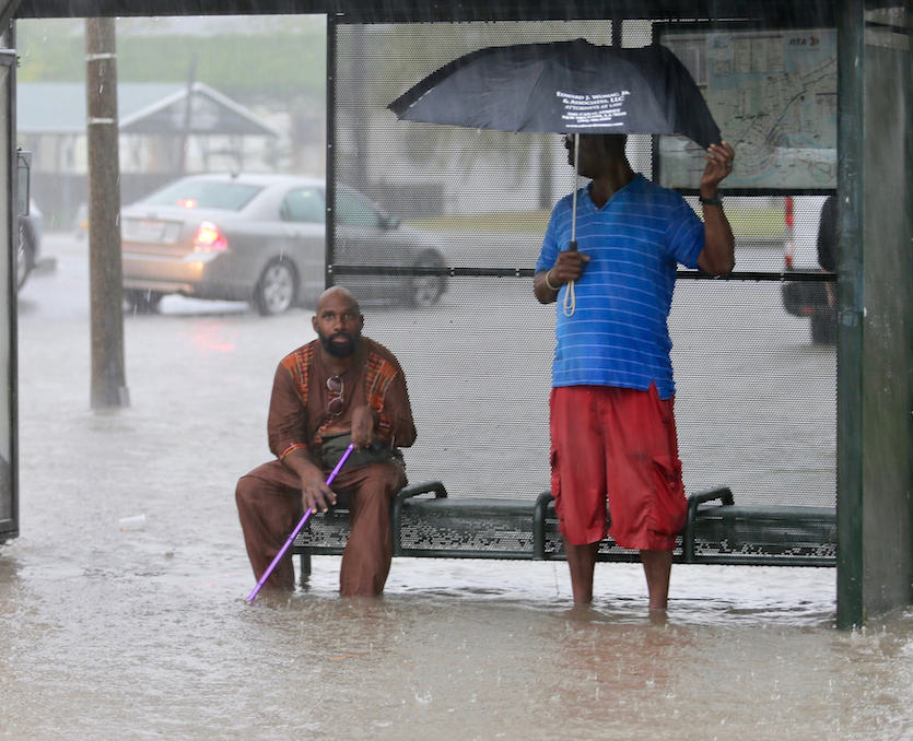
In turn, the heaviest thunderstorms associated with PTC 2 on Wednesday morning were actually well northwest of the low-level center, in a convective complex that churned across the New Orleans area. The heavy storms prompted a flash flood emergency and inundated parts of the central city with more than 10” of rain.
Parts of #nola metro now have picked up 10 inches of rain this AM, per @wunderground pwss. And #Barry hasn't "formed" yet. https://t.co/6kopjo6shx pic.twitter.com/1n4eukgzhu
— Jonathan Erdman (@wxjerdman) July 10, 2019
 |
| Figure 1. Residents sit under a bus shelter along a flooded Broad Street as heavy rain falls on Wednesday morning, July 10, 2019, in New Orleans. Image credit: David Grunfeld/The Advocate via AP. |
Track and intensity forecast for Barry
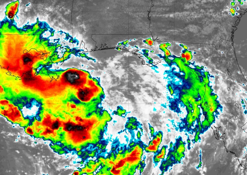
An Air Force hurricane-hunter mission was on its way into PTC 2 early Wednesday afternoon. The mission should provide more clarity on the state of Barry’s low- and mid-level circulation features, including whether a closed low-level circulation is present. As soon as a closed center can be identified, NHC is expected to upgrade the system to a tropical depression or to Tropical Storm Barry. On Wednesday night, we are likely to see thunderstorms consolidating around the low- and mid-level centers offshore, especially if and when these centers become more vertically stacked. Update (5 pm EDT): The hurricane hunters found that the circulation remained poorly defined, with surface winds in the range of 20-33 knots (23-35 mph) well south of the center.
 |
| Figure 2. Infrared image of Potential Tropical Cyclone 2 as of 1802Z (2:02 pm EDT) Wednesday, July 10, 2019. Most of the intense thunderstorms were located to the northwest of Barry's ill-defined center south of the Florida Panhandle. Image credit: tropicaltidbits.com |
Tropical cyclones located this close to the upper Gulf Coast do not always have time to develop into hurricanes, but PTC 2 could be an exception. Models agree that the system will carry out a slow, looping path across the northern Gulf, eventually arcing toward the coastline around Saturday. There are still model disagreements on how far east or west Barry will come ashore, with solutions ranging from the Texas/Louisiana border (0Z Wednesday run of the European model) to western Mississippi (12Z Wednesday run of the HMON model). The official NHC outlook issued late Wednesday morning brings Barry onshore in southwest Louisiana on Saturday afternoon or evening as a Category 1 hurricane, with the center continuing north-northwest toward the Arklatex region by Monday. A farther-west landfall would give Barry more time to intensify, but model trends on Wednesday morning were decidedly toward the eastern side of the envelope.
The most likely outcome is for Barry to reach the coast as a Category 1 hurricane, as predicted. It could come ashore as a strong tropical storm if it hugs the coast more closely. Barry is unlikely to have enough time to reach Category 2 strength, although this can’t yet be ruled out. In any event, the wind damage threat from PTC 2 is likely to be outweighed by the water-related threats.
The biggest threats: rainfall and surge
PTC 2’s slow movement raises the prospect of enormous rainfall totals along the central Gulf Coast. Much will depend on just how far offshore Barry remains and where its strongest convection evolves—details that are too soon to resolve. Still, most of the model solutions point toward widespread 5-10” totals across southern Louisiana. Localized totals could reach 18”, according to NHC, and given the heavy rains this morning in the New Orleans area, a few storm totals well above 20” are certainly possible. Periods of flash flooding are highly likely throughout the region. Rains in southeast Louisiana will be maximized if PTC 2 takes a more eastward track with a landfall in central Louisiana, as suggested by the 12Z runs of the European and GFS models.
While PTC 2 is not expected to produce massive storm surge, there will be a prolonged period of onshore flow that could produce coastal flooding over more than one tidal cycle, especially from late Thursday into early Saturday. With the full moon of July 16 approaching, the astronomical high tide across southern Louisiana will be running about 1 to 1.5 feet above average. All told, in the storm surge warning area, peak inundations above ground level in the storm-surge watch area could reach 3 to 6 feet at high tide, assuming PTC 2 evolves into a Category 1 storm and moves as currently predicted.
 |
| Figure 3. Forecast as of Wednesday morning, July 10, 2019, for the Mississippi River at the Carrolton Gauge near Audubon Park in New Orleans. The river was predicted to crest on Saturday morning at 20 feet, near the top of the levee system protecting the city from the river. The last crest this high was on May 18, 1927. Image credit: NOAA/NWS/AHPS. |
Floodwaters may challenge the Mississippi River levees in New Orleans
One particular concern is in New Orleans, due to the combination of PTC 2’s effects and high water along the Mississippi River. Defenses against a Gulf of Mexico storm surge that were bolstered after 2005’s Hurricane Katrina performed well during 2012’s Hurricane Isaac, a large, slow-moving Category 1 storm with 80 mph winds that brought a storm surge characteristic of a Category 2 storm to New Orleans. However, an Achilles’ heel remains: the levees around the Mississippi River, which are now only high enough to protect New Orleans from the type of upriver surge one might expect from a Category 1 storm. Typically, the Mississippi is running low enough by late summer to reduce the risk of a surge traveling upriver and affecting the city. However, we have a rare and unfortunate coincidence at hand: an early-season tropical cyclone approaching at the same time that the Mississippi is running unusually high after months of heavy rain in the Plains and Midwest.
The Wednesday-morning forecast from NWS shows the Mississippi cresting in New Orleans on Saturday at a height of 20 feet. A crest this high, which has not seen since the Great Flood of 1927, would bring water to the top of the river’s levee system. “We have had high-water events in hurricane season but we’ve never had an elevation forecast like this,” Corps spokesman Ricky Boyett told Mark Schliefstein (nola.com) on Tuesday, when the forecast was for a 19-foot crest.
Jeff Masters will have more details on the Mississippi situation in our next post later today.


