
| Above: A sharp upper low is predicted by the 18Z Monday run of the GFS model to be centered over the Texas Panhandle, with a surface low trekking across Arkansas, at 1 am EST Saturday, January 11, 2020. Winds are shown in knots (multiply by 1.15 for miles per hour). Severe weather is expected to break out in warm, unstable air near and southeast of the surface low. Image credit: tropicaltidbits.com. |
After a mostly tranquil weather start to the new year for the United States, a powerful upper-level system will trigger what could be a multi-day spell of widespread severe weather from Friday into Saturday. All the ingredients for severe thunderstorms—including the potential for multiple tornadoes—are showing up in computer models, though it remains to be seen exactly where and when the elements may occur. In addition, several belts of heavy rain and potential flooding may develop over the South and Midwest in the next week or more, and a corridor of heavy snow could set up just to the north.
The NOAA/NWS Storm Prediction Center has taken the unusual step of issuing a severe weather outlook for Days 5 and 6 (Friday and Saturday). The risk on Friday is comparable to a Day 1 “enhanced” level, which is also the highest level employed by SPC in any outlooks issued so far in advance. Only a handful of events over the past decade have prompted this risk level in the Day 4-8 range. It’s certainly possible the risk level will increase as the event gets closer.
 |
| Figure 1. Severe weather outlook issued on Monday, January 6, 2020, for Friday (left) and Saturday (right), January 10-11. Image credit: NOAA/NWS/SPC. |
The situation will begin to coalesce on Friday, when the upper low dives toward the south-central U.S. and a surface low begins to take shape in or near Texas. Powerful upper-level winds will accompany the low, and the configuration of winds surface and aloft will provide ample vertical wind shear. As the upper low pivots late Friday into Saturday, it may take on a slight negative tilt (a northwest-to-southeast orientation), which tends to favor severe weather.
It’s not that unusual to get severe weather from Texas into the Deep South in midwinter. A two-night tornado outbreak took more than a dozen lives across the South in late January 2017. What’s most noteworthy about this setup is the summerlike nature of the tropical air mass that will be pumped from the Caribbean into the Gulf Coast and Southeast. Surface dew points may climb above 70°F in some areas, and precipitable water (PW) values (the total amount of moisture in an imaginary column above the surface) may top 1.50” from southeast Texas on Friday night all the way to Maryland by Saturday night. Especially in the mid-Atlantic, such moisture would rival the highest PW values for any January in upper-level records going back to the 1940s.
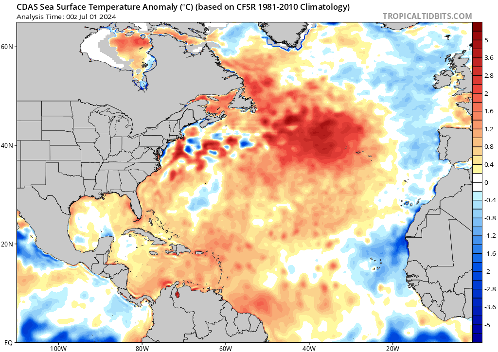
 |
| Figure 2. Sea surface temperatures were around 1°C (1.8°F) above the seasonal average over large parts of the Gulf of Mexico and Caribbean as of Monday, January 6, 2020. Moist air above these warm waters will be flowing into the Southeast U.S. late this week. Image credit: tropicaltidbits.com. |
Upper-level dynamics are so strong in winter systems like this that even modest amounts of instability (a function of warm, moist air near the surface and cold air aloft) can be enough to support tornadoes and other severe weather. The projected values would certainly throw fuel on the fire. What’s more, a layer of warm, dry air may stream from northern Mexico across Texas toward the Southeast. This would serve as a “cap”—a feature common in springtime that can help keep storms from developing at first but that allows storms to draw on increased instability once they do form.
If the cap ends up being absent or weak, then showers and thunderstorms could become widespread enough to dampen instability and dent the risk of the worst severe weather.
Another concern about the unusually rich moisture is that it will keep surface temperatures on the mild side even after the sun goes down. Lows early Saturday could be well into the 60s across much of the South. These readings would approach daily and perhaps even some monthly records for record-warm minima. With Friday night so mild, severe weather could extend well into the night. The long nights of midwinter enhance the threat of tornadoes after dark, when visibility is poor and people may be caught asleep or otherwise unaware.
 |
| Figure 3. 7-day precipitation forecast for the period from 7 pm Monday, January 6, 2020, to Monday, January 13. Image credit: NOAA/NWS/WPC. |
Flooding rains and winter weather also a concern
As the surface low translates from Texas to New England along a frontal zone, a concentrated zone of heavy precipitation is likely to form over the Ohio Valley along and just north of the front. Amounts from 2” to 5” may be common from Arkansas to western New York. Some or all of this moisture could fall as snow or freezing rain along the northern fringes of this zone. A narrow band of heavy frozen precipitation is possible over the Corn Belt, and even heavier snow or ice could develop from the Adirondacks to western Maine.
Recent rains have left the soil wet across much of the Southeast, so we’ll have to watch out for flooding where the rains are heaviest. Another band of frontal rains may develop in the mid-South next week


