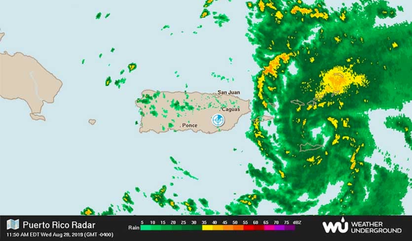
| Above: Puerto RIco radar at 11:50 am EDT August 28, 2019. |
Dorian was close to hurricane strength late Wednesday morning as it battered the Virgin Islands and Puerto Rico with heavy rains and strong winds. Confidence is increasing that it will approach the Southeast U.S. early next week as a major hurricane. Update (1 pm EDT Wednesday): Dorian is now a hurricane with top winds of 75 mph, according to the 2 pm EDT advisory from the National Hurricane Center.
At 11 am EDT Wednesday, Tropical Storm Dorian was at the verge of hurricane strength, with top sustained winds of 70 mph, moving into the U.S. and British Virgin Islands. Hurricane warnings were flying for all of the Virgin Islands, plus Vieques and Culebra islands in Puerto Rico. San Juan, Puerto Rico radar and satellite imagery showed a much improved structure for Dorian compared to yesterday--a compact storm with increasing low-level spiral banding and a developing eyewall of heavy thunderstorms near the core. An expanding area of healthy upper-level outflow was also apparent. A cloud-free center that is likely to become an eye was beginning to appear on satellite imagery.
 |
| Figure 1. Visible satellite image of Dorian entering the Virgin Islands at 11:10 am EDT August 28, 2019. A cloud-free center that is likely to become an eye was beginning to appear. Image credit: NOAA/RAMMB. |
Winds on Saint Thomas in the U.S. Virgin Islands at 1:17 pm Wednesday were 72 mph, gusting to 94 mph. Saint Thomas was in the developing northern eyewall of Dorian. Peak winds at Christiansted on Saint Croix in the U.S. Virgin Islands were sustained at 34 mph, gusting to 44 mph, at 11 am EDT Wednesday. Dorian is on a track that will take it through the core of the Virgin Islands on Wednesday afternoon, and near Puerto Rico's Culebra Island and Vieques Island Wednesday evening. The northeast corner of the mainland Puerto Rico is also likely to receive tropical storm-force winds from Dorian. Culebra, which will be on the stronger northern side of Dorian's circulation, is likely to see the highest winds of any location so far in the Caribbean from Dorian's passage.
NOAA’s Weather and Hazards Data Viewer is a good way to see an interactive map of the current weather conditions at official weather sites. Our wundermap with the Weather Stations/Precipitation option selected is a good way to follow the rainfall reports at personal weather stations (PWSs). As of 12:23 pm Wednesday, the highest rainfall amount from Dorian in the Virgin Islands was 2.26” on Saint John.
High winds from Dorian are likely to cause significant damage in the tens of millions of dollars to the fragile infrastructure of the Virgin Islands and eastern Puerto Rico devastated by Hurricane Maria and Hurricane Irma in 2017. Heavy rains of up to 4 - 6", with isolated amounts up to 10", are likely to cause destructive flash flooding as well.
Short-term intensity forecast for Dorian
Dry air with a mid-level relative humidity near 45% will continue to slow down Dorian’s intensification rate today, but low wind shear less than 10 knots and very warm water (around 29°C or 84°F) extending to some depth should allow intensification into a Category 1 hurricane by Thursday, if not sooner. The 12Z Wednesday run of the SHIPS model Rapid Intensification Index gave a 42% chance of Dorian’s winds increasing by 30 mph by 8 am EDT Thursday, which would make it a Category 1 hurricane with 90 mph winds. However, the left side of Dorian will experience the rough terrain of Puerto Rico tonight, which might cause some minor disruption of the storm, and the NHC forecast of Dorian being a 75 mph Category 1 hurricane north of Puerto Rico on Thursday morning is a reasonable one.
 |
| Figure 2. Predicted wind speeds (colors) and pressure (black lines) for Dorian at 2 pm EDT Sunday, September 1, 2019, from the 6Z Wednesday, August 28, 2019 run of the HWRF model. This model, one of our top three performing intensity models at long ranges last year, was predicting that Dorian would make landfall as a borderline Category 3 or 4 hurricane with 130 mph winds on the central coast of Florida. Image credit: tropicaltidbits.com |
Southeast U.S. at risk of a major hurricane strike
Conditions for intensification will steadily improve Thursday through Saturday as Dorian heads northeast past The Bahamas and towards the Southeast U.S. coast. The atmosphere will steadily moisten, reaching a mid-level relative humidity of 65% by Saturday. Wind shear will be light to moderate (5 – 15 knots), and Dorian will be traveling over very warm water (around 29 – 29.5°C or 84 - 85°F), with an oceanic heat content (OHC) in excess of 50 - 80 kilojoules per square centimeter--a level very supportive of rapid intensification. The 12Z Wednesday run of the SHIPS model Rapid Intensification Index had a 39% chance of Dorian becoming a 125 mph Category 3 hurricane by Friday morning, though the newer DTOPS model had only a 6% chance.
Our top three intensity forecast models last year at long ranges (4 – 5 day forecasts) were the GFS (legacy), HWRF, and LGEM models (Figure 3 below). The 0Z and 6Z Wednesday runs of all three models predicted that Dorian would intensify to a Category 3 or 4 hurricane this weekend as it approaches the Southeast U.S. coast. The new GFS model that debuted this year does not yet have stats on its intensity skill; its 4 – 5 day intensity forecasts this morning were more restrained, calling for a Category 1 or 2 hurricane on Sunday and Monday. The experimental COAMPS model called for Dorian to reach Category 5 strength, and the SHIPS model called for a Category 2 storm.
Bottom line: expect Dorian to undergo a round of rapid intensification sometime Thursday or Friday, which will bring it to at least Category 3 strength as it approaches the Southeast U.S. coast on Saturday.
 |
| Figure 3. Verification of NHC’s top intensity models for Atlantic tropical cyclones in 2018. The European model had the poorest performance of any of these models at all forecast times. The best-performing model at longer time scales (3 – 5 days) was the GFS model, while the best-performing model at shorter time scales (1/2 – 2 days) was the HWRF model. The official National Hurricane Center intensity forecast was superior to all models at the 4- and 5-day time frames. Image credit: NHC 2018 verification report. |
Track forecast for Dorian
Dorian’s track forecast is fairly straightforward until this weekend, when its approach to the Southeast U.S. coast is coupled with a rapid divergence in model forecasts. Dorian’s track has shifted 50-100 miles to the north and east as a result of the storm’s surface center redevelopment on Tuesday afternoon. This is why Dorian is moving between Puerto Rico and the U.S. Virgin Islands, rather than shooting the gap between the Dominican Republic and Puerto Rico. Philippe Papin (Naval Research Laboratory) has an excellent Twitter thread showing how this shift evolved and what it means going forward.
1/9: Over the last 24 hours there have been large eastward shifts in #Dorian's track. It may now just clip #PuertoRico to the east! How?
— Philippe Papin (@pppapin) August 28, 2019
Let's start with Dorian's vertical structure. One critical change is how vertically coherent Dorian's vortex has become, as seen below. pic.twitter.com/qlNVbAa3c3
For the next day or two, the latest ensemble forecasts (0Z Wednesday) from the GFS and European models agree that Dorian will be moving primarily northwest, staying mostly east of The Bahamas. By late this week, Dorian will feel the effects of a Bermuda high strengthening to its north and a weak upper-level low moving from The Bahamas toward the Caribbean. Together, these will push Dorian more toward the west to west-northwest.
By Saturday, the GFS and European ensembles largely agree that Dorian will be heading toward the central or northern Florida coast, with some uncertainty on its forward speed. The models begin to diverge as Dorian gets closer to landfall and the steering pattern gets more complex. There also remains some timing uncertainty in the ensembles, with some members showing a Florida landfall on Sunday while others have Dorian well offshore.
By Monday, the divergence in outcomes becomes stark. Some ensemble members have Dorian moving west through the Gulf of Mexico, while others have it moving northward off the Southeast coast. The model consensus remains a landfall on Sunday or Monday along the central to northern Florida coast, with the official NHC forecast at 11 am Wednesday showing landfall near the Space Coast on Monday morning. However, the entire Southeast U.S. coast—from South Florida to the Carolinas—needs to stay abreast of Dorian’s evolution. Now is an excellent time to keep in mind that the average 5-day track error over the past five years of NHC forecasts is around 200 miles.
#Erin has weakened to a Tropical Depression, but is still expected to bring heavy rain and strong winds to the Maritimes by the end of the week.
— The Weather Network (@weathernetwork) August 28, 2019
Bob Henson co-wrote this post.


