| Above: An unusual sight: the National Hurricane Center (NHC) Graphical Tropical Weather Outlook at 8 am EDT Monday, July 8, 2019, showing a disturbance well inland over Georgia that has the potential to emerge over water and develop into a tropical cyclone. NHC gave the system 2-day and 5-day odds of development of 10% and 80%, respectively. Image credit: NHC. |
An area of low pressure over Georgia on Monday morning was headed south towards the Gulf of Mexico at about 5 mph and has the potential to develop into a tropical storm late this week after emerging into the Gulf. The National Hurricane Center (NHC) designated this system as Invest 92L on Monday morning. Regardless of development, a large section of the northern coast of the Gulf of Mexico should expect to see very heavy rains of 5+ inches Tuesday through Sunday.
 |
| Figure 1. Predicted 7-day rainfall amounts ending at 8 pm EDT Monday, July 15, 2019. A tropical disturbance (92L) is predicted to bring heavy rains of 5+ inches (orange colors) to Gulf Coast from Texas to Western Florida. Image credit: NOAA. |
Favorable conditions for development predicted
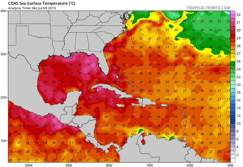
Generally favorable conditions for development are expected late this week over the northern Gulf of Mexico. Florida has seen one its hottest Junes on record, and this has allowed sea surface temperatures (SSTs) over the northeastern Gulf to become unusually warm, near 30 - 31°C (86 - 88°F). This is up to 2°C (3.6F) above average for this time of year. Wind shear is predicted to be low to moderate, and the atmosphere will be moist enough to support development—though some dry air over Louisiana may wrap into the disturbance on Wednesday, slowing development.
All three of our top models for predicting tropical cyclone formation—the European, GFS, and UKMET models—predicted with their 0Z Monday runs that a tropical depression or tropical storm would develop in the northeastern Gulf of Mexico on Thursday. By Thursday, steering currents over the Gulf of Mexico will shift, resulting in 92L turning to the west and moving at a forward speed of 5 – 10 mph. On this track, the models agree that the system should make landfall somewhere along the Louisiana or Texas coast on Saturday.
 |
| Figure 2. SSTs in northern Gulf of Mexico on July 8, 2019 were 29 - 31°C (84 - 88°F), well above the 26.5°C benchmark for tropical cyclone development, and 1 - 2°C (1.8 - 3.6°F) above average. Image credit: tropicaltidbits.com. |
The main impediment to development would appear to be the amount of time 92L has over water. The system will be disorganized when it moves over the Gulf of Mexico on Tuesday night or Wednesday morning, and it will likely take the disturbance two days to take advantage of the favorable conditions for development and become a tropical storm. A hurricane hunter aircraft is on call to investigat 92L on Wednesday.
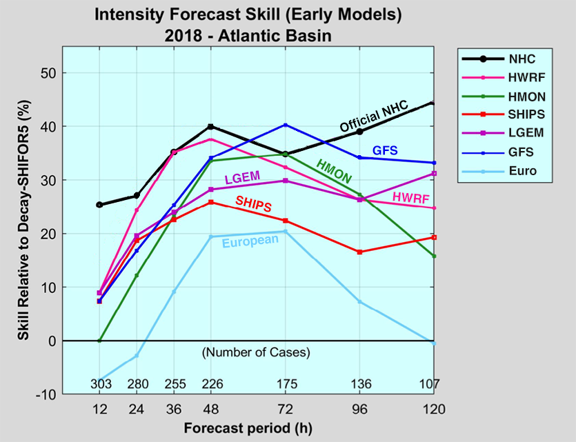
Very few of the members of the 0Z Monday GFS and European model ensemble forecasts predicted that 92L would have time to develop into a hurricane. The most gung-ho forecast for development was from the operational version of the 0Z European model, which predicted 92L would be near Category 1 hurricane strength with a 988 mb central pressure by Saturday at landfall in Texas. While this model has generally made the best track forecasts averaged over the past three years, it has made relatively poor intensity forecasts. NHC’s 2018 verification report (Figure 3) showed that the GFS model far out-performed the European model in 2018 on intensity forecasts (though that was the “legacy” GFS model, which has since been replaced by the upgraded “FV3” version; the 12Z Monday run of the legacy version of the GFS has 92L as a mid-strength tropical storm with a 998 mb central pressure at landfall late Satuday night in Louisiana). The latest 12Z Monday run of the GFS model predicted that 92L would be a weak or mid-strength tropical storm with a 1003 central pressure by the time of landfall in Texas on Saturday. Two of our other top intensity models, the SHIPS and LGEM, were not predicting that 92L would become a tropical storm in their 12Z Monday runs, since they did not have the system pushing far enough offshore. These solutions look unrealistic, since the global models show 92L pushing far enough offshore to develop into a tropical storm.
 |
| Figure 3. Verification of NHC’s top intensity models for Atlantic tropical cyclones in 2018. The European model had the poorest performance of any of these models at all forecast times. The best-performing model at longer time scales (3 – 5 days) was the GFS model, while the best-performing model at shorter time scales (1/2 – 2 days) was the HWRF model. Image credit: NHC 2018 verification report. |
There is higher than usual uncertainty in the forecast at this point, since small-scale details of where thunderstorms develop during the next few days when the disturbance is over land will ultimately determine where and when the center emerges over water and how far offshore it will ultimately get. At this point, we can be confident that much of Gulf Coast will get a soaking, and that we will likely see a Tropical Storm Barry in the Gulf of Mexico by Saturday.
Difficult to say which evolution is more correct, but I might give the edge to more southern development (Euro), since based on wind pattern for Tues morning, convergence of long fetch of richly moist boundary layer air will be focused west of Tampa, promoting convection there. pic.twitter.com/n6VRh7MsC4
— Levi Cowan (@TropicalTidbits) July 8, 2019


