| Above: Rainfall in the two-week period ending at 6 am CST Friday, February 22, 2019, as estimated from a blend of rain-gauge and radar data. Image credit: NOAA/NWS Advanced Hydrologic Prediction Service. |
An uncommonly wide range of precipitation threats will confront the U.S. from Friday into the weekend. An intense late-winter storm developing in the Southern Plains late Friday will rip across the Great Lakes by Sunday morning, accompanied by severe weather and a major flood threat to its southeast and blizzard conditions to its northwest. There’s even an early-season major typhoon that will affect the U.S. territory of Guam on Saturday and Sunday local time.
 |
| Figure 1. Excessive rainfall threat area for the period from 9 am CST Friday, February 22, 2019, to 6 am Saturday. Image credit: NOAA/NWS/WPC. |
Early Friday, the NOAA/NWS Weather Prediction Center issued a high-risk area for excessive rainfall (enough to trigger flash flooding) from Friday into early Saturday, covering northern Mississippi and parts of southern and central Tennessee.
WPC issues only a few high-risk days for excessive rainfall each year, but for the period 2014-2017, these days accounted for 92% of U.S. flood-related damage and 41% of flood-related fatalities, according to meteorologist Alex Lamers.
The center warned of “a significant, and potentially life-threatening, flash flooding threat through tonight.”
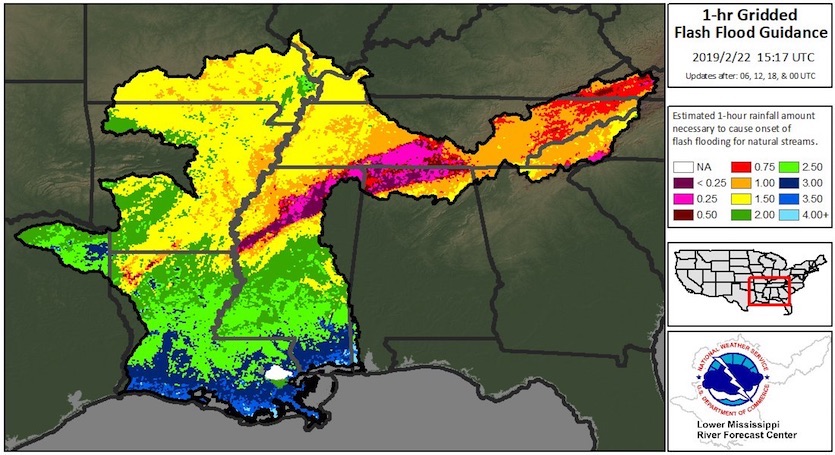
Weeks of heavy rain have pummeled the mid-South, leading to large areas of saturated soils. As little as 0.25”/hour of rain could lead to flash flooding in some areas, and a widespread 2”-5” of rain is expected Friday into early Saturday. Water rescues were taking place on Friday morning near Grenada, Mississippi, where a mesonet station reported 8.31" from Thursday through 7:45 am Friday. A narrow corridor of intense rain parked over Mississippi on Friday morning is expected to evolve into a broader area of heavy rain on Friday night.
For the month of February, Nashville, Tennessee, had racked up 10.71” of rain through Thursday. With another 3”-4” expected through Saturday, the city appeared very likely to douse its previous February precipitation record of 12.37” from way back in 1880.
 |
| Figure 2. One-hour flash flood guidance for the Lower Mississippi region as of Friday morning, February 22, 2019. One-hour rainfall amounts greater than those shown could trigger flash flooding of natural streams. See the website for the latest guidance, which is updated every six hours. Image credit: NOAA/NWS Lower Mississippi River Forecast Center. |
Tornadoes and tree-felling winds a threat for Saturday
The same region struggling to keep its head above water Friday will be plagued with a fast-moving round of severe weather on Saturday. In its Day 2 outlook issued midday Friday, the NOAA/NWS Storm Prediction Center placed parts of Arkansas, Mississippi, and Tennessee under an enhanced risk of severe weather. One or more strong tornadoes are possible on Saturday.
Still a lot of uncertainty regarding how far northward the severe threat will develop tomorrow. If warm, moist air makes it into Kentucky, southern Indiana, upgrades to higher risk categories may become needed. In any event, some strong tornadoes are possible tomorrow. https://t.co/Gg0lQxM3Qe
— Patrick Marsh (@pmarshwx) February 22, 2019
A more widespread threat will be posed by very strong downburst-type winds expected to rip through the area as part of a squall line on Saturday evening. Given the extremely wet soils, we can expect an unusually large number of trees to be uprooted, which could pose a serious safety hazard on top of the ongoing high water.
High winds will also overspread the eastern Great Lakes and adjacent areas, especially from early Sunday into early Monday. Millions of residents are already under high wind watches and warnings in advance of the weekend tempest. This could be one of the most intense high-wind events in recent years for the eastern Great Lakes.
Powerful southwest winds will gust up to 75 mph from Sunday morning through late Sunday night. Winds of this magnitude will result in significant water rises and ice movement on both Lake Erie & Ontario. #NYwx Read more: https://t.co/Su5UJj6XaA pic.twitter.com/ngcH4mknLL
— NWS Buffalo (@NWSBUFFALO) February 22, 2019
Powerful southwest winds will gust up to 75 mph from Sunday morning through late Sunday night. Winds of this magnitude will result in significant water rises and ice movement on both Lake Erie & Ontario. #NYwx Read more: https://t.co/Su5UJj6XaA pic.twitter.com/ngcH4mknLL
— NWS Buffalo (@NWSBUFFALO) February 22, 2019River flooding on the way: Mississippi rising
Beyond the immediate threat of flash flooding, several days of river flooding are in store for the Tennessee, Ohio, and Lower Mississippi valleys, as runoff moves downstream into larger waterways. Major flooding is projected this weekend along the Ohio River in western Kentucky and early next week along the Tennessee River in western Tennessee.
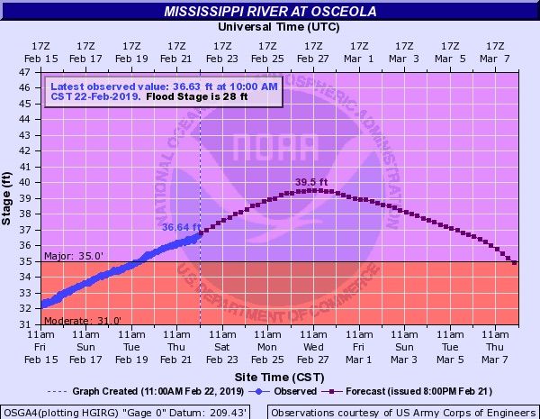
As these crests work their way into the Mississippi River, they will cause major flooding on the Father of Waters, potentially forcing the Army Corps of Engineers to open the flood gates of the Bonnet Carré Spillway. As of Friday, the Lower Mississippi was already at major flood stage at Osceola, Arkansas, and is predicted to reach major flood state at Baton Rouge, Louisiana and Vicksburg, Mississippi during the first week of March.
 |
| Figure 3. Flood forecast for the Mississippi River at Osceola, Arkansas, as of Friday morning, February 22, 2019. The river was at major flood stage, and was predicted to crest on Wednesday, February 27, at 39.5’, which would be its fourth highest level since 1975. At this level, the town of Ashport, Tennessee (population 4000) is flooded, along with Highway 19. Image credit: USGS. |
The latest National Weather Service forecast predicts that the river will rise to minor flood stage in New Orleans on March 12, reaching a height of 17’ on the Carrolton gauge. Levees protect New Orleans against floods only three feet higher than that. When the river reaches minor flood stage, the Army Corps is authorized to open the gates of the Bonnet Carré Spillway, located between New Orleans and Baton Rouge, in order to lessen the pressure on the levees in New Orleans.
When all 350 bays are opened, the spillway can divert one-fifth of the river’s water into Lake Pontchartrain. The last time all 350 bays were opened was in 1983. The spillway has been opened just twelve times since 1937, but with increasing frequency in recent years—four of the twelve openings have occurred since 2008. The spillway was last opened in March 2018, when it was operated at approximately half of its capacity. Athough the spillway drains water into Lake Pontchartrain through uninhabited land, operation of the spillway does come with a cost: the excess fresh water that drains into the Gulf of Mexico is harmful to the oyster industry. The prolonged opening of the spillway in 2011 likely cost the oyster industry $22 - $46 million and the loss of several hundred jobs during the period 2011 – 2013, according to an analysis by Mississippi State University.
We should also keep an eye on the river’s level at Red River Landing, located near the Old River Control Structure in Louisiana. Current forecasts have the river cresting there at its ninth highest level since records began in 1927. See our 2011 post, America’s Achilles Heel: the Mississippi River’s Old River Control Structure.
Weather.com published an excellent long-form piece on the Bonnet Carré Spillway back in 2016, which has a very detailed look at its history, function and ecological impacts.
Worrisome signals for spring flooding
More than 120 stations across the Midwest had their wettest year on record in 2018 (see PDF), and both January and February have been largely wet months as well. One to two feet of snow now blankets much of eastern North Dakota, Minnesota, and Wisconsin. Soil moisture is close to record-high levels due to several early-winter melts prior to the recent cold, snowy conditions. With a week still left in the month, this is already the snowiest February on record from Minnesota to Wisconsin, according to the NWS North Central River Forecast Center (NCRFC). Saturday’s storm will produce widespread blizzard conditions from the central Plains to the Midwest, along with as much as 4-8” of snow over parts of Minnesota and Wisconsin.
NOAA’s initial outlooks for spring flooding along the Upper Mississippi, issued on Thursday, are quite concerning. “The outlook for March suggests colder than normal temperatures across the entire NCRFC area,” noted the NCRFC. “This suggests we may have additional snowfall accumulation, and a delay in warming to allow for melting. If this does occur, it increases the likelihood for a rapid melt scenario once the warmer temperatures arrive later this spring.”
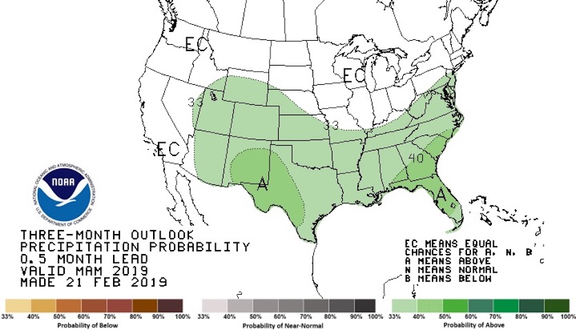
NCRFC is calling for an above- to well-above-normal flood threat along the Upper Mississippi, depending largely on how the next couple of months unfold in terms of temperatures and snowpack. Further south, along the Mid- and Lower Mississippi, the spring flood threat will hinge not only on conditions upstream but also on how much additional rain falls across the region. Unfortunately, the latest seasonal outlook from NOAA calls for higher-than-average odds of a wet spring across the southern half of the nation. The weak El NIño event now in place favors wetter-than-usual conditions in this area.
 |
| Figure 4. Precipitation outlook for March through May 2019, issued on Thursday, February 21, 2019. Areas marked “EC” have equal odds of above-, below-, or near-average precipitation. Areas in green show where the odds are shifted in favor of a wet spring. Image credit: NOAA/NWS/CPC. |
Rare snow in L.A. area; record snow in Flagstaff
The intense, cold upper-level low that will storm the nation’s midsection this weekend gave the Los Angeles region an unusual taste of snowfall on Thursday. According to the NWS/Los Angeles office, snow showers were reported at elevations between around 700 and 1000 feet by spotters in Thousand Oaks, Simi Valley, Calabasas, Northridge, and Pasadena. “Most amazingly, snow was even reported right at some beaches, including Malibu Pier and Leo Carrillo Beach, and near sea level at Fire Station 71 at Point Dume,” said the office. “In most areas, the snow melted as it hit the ground.”
Las Vegas got lucky as well, at least from a snow lover’s perspective. The city’s airport received 0.5” of snow on Wednesday and 0.3” on Thursday, following traces of measurable snow on Sunday and Monday. All four days set daily snowfall records for the city. Several inches of snow fell during both storms in the higher terrain near Las Vegas.
And snow falls on @stratvegas. Outside observation deck on Stratosphere in Las Vegas is closed, however. pic.twitter.com/3NQpkTgdAP
— David Montero (@DaveMontero) February 21, 2019
In Arizona, the normally snowy high-altitude city of Flagstaff (altitude 6910 feet) saw its snowiest calendar day on record Thursday. The total of 35.9” buried the old one-day record of 31” set on Dec. 30, 1915. There was just 1.44” of liquid in Thursday’s snow, which meant the average snow-to-liquid ratio for the day was a very fluffy 25 to 1. For the month to date, Flagstaff has seen 67.9” of snow and 6.22” of liquid equivalent. It’s possible that one or more locations in Arizona topped the state 24-hour record of 38”, set in 1967 and matched in 1987.
Even Tucson got in the act, with 1.5” of snow at the city’s airport as of late Friday morning—the city’s heaviest snow in six years.
The widespread moisture across the Four Corners region is a welcome development for this region. A series of hot, dry years in the last couple of decades have bolstered wildfire risk and put lakes Powell and Mead—the region’s main water source—well below capacity. Drought conditions have been reduced substantially over the last month, as reported by Linda Lam at weather.com.
Don’t worry @AZSchoolPR, we will have all the snow cleared out by The June conference. #flagstaff #SnowMageddon2019 pic.twitter.com/lJ5wX9KyW5
— Zach Fountain (@ZFount) February 22, 2019
 |
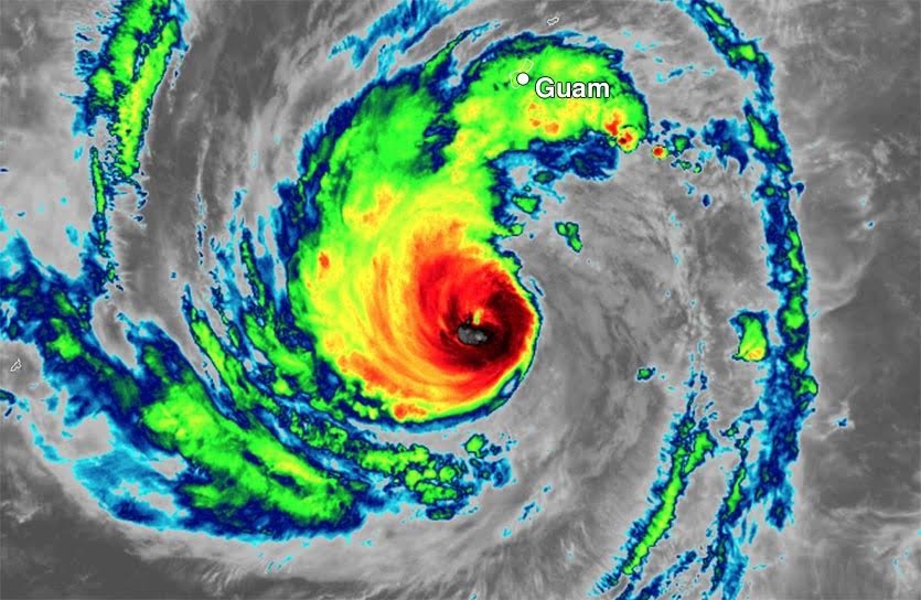
| Figure 5. Himawari-8 infrared image of Typhoon Wutip taken at 11:00 am EST Friday, February 22, 2019. At the time, Wutip was a Category 3 storm with 120 mph winds, headed northwest at 15 mph on a track that would take it 160 miles southwest of Guam on Saturday. Image credit: NOAA/RAMMB. |
First major typhoon of 2019, Typhoon Wutip, lashing Guam
The first Category 3 storm of the 2019 Northern Hemisphere tropical cyclone season is Typhoon Wutip, which was located several hundred miles to the south of Guam on Friday afternoon, heading northwest at 15 mph. See our previous post for information on how unusual it is to get a February typhoon in these waters.
The 10 am EST Friday advisory from the Joint Typhoon Warning Center put Wutip’s top winds at 120 mph, making it a mid-strength Category 3 storm. With wind shear a moderate 15 – 20 knots and sea surface temperatures a warm 29°C (84°F), Wutip should be able to maintain Category 3 intensity until 12Z Saturday (10 pm local time), when the typhoon will be making its closest pass to Guam—about 160 miles to the island’s southwest. By Sunday, when Wutip will be swinging to the north-northwest, passing about 250 miles to the west of the Mariana Islands, the storm will experience increasing wind shear and decreasing SSTs, which should cause slow weakening.
A Tropical Storm Warning is up for Guam, which is likely to experience a 12-hour+ period of sustained winds of tropical storm-force beginning near 0Z February 23 (10 am Saturday local time). Waves near the coast will potentially exceed 20 feet on Saturday and Saturday night. Heavy rains of 5 – 8 inches will pose a flood threat, and a Flash Flood Watch is posted for the islands of Guam and Rota. Guam is used to strong typhoons, and the close brush by Wutip should not cause a large amount of damage.
Jeff Masters wrote the Mississippi River and Wutip portions of this post.


