| Above: Natural-color image of Tropical Storm Barry as of 1645Z (12:45 pm EDT) Friday, July 12, 2019. Image credit: tropicaltidbits.com. |
Residents of southeast Louisiana need to finalize preparations for widespread and severe flooding this weekend with the approach of Tropical Storm Barry. Packing top sustained winds of 65 mph, slow-moving Barry will push its way onshore Saturday, possibly as a Category 1 hurricane. What matters most with Barry isn’t a Saffir-Simpson rating, though, but instead the massive rains it will dump on a highly vulnerable region—most of it arriving well after landfall from Saturday into Sunday.
“It doesn’t matter what the storm is called,” emphasized weather.com’s Jon Erdman. “We are still expecting a major rainfall flood event.”
As of 2 pm EDT Friday, Barry’s low-level center was about 105 miles west-southwest of the mouth of the Mississippi River. A mesovortex (small-scale low) visible on satellite imagery was approaching the Louisiana coast early Friday afternoon, rotating around the low-level center, while Barry’s mid-level center and most of its showers and thunderstorms were located further offshore, well south of the surface low. Barry was drifting west-northwest at about 5 mph on a path that will gradually arc toward the northwest and north this weekend.
A hurricane warning was in place at midday Friday from Intracoastal City, Louisiana, east to Grand Isle, with a storm surge warning from Intracoastal City to Biloxi, Mississippi, including Lake Ponchartrain. Tropical storm warnings were in effect on either side of the hurricane warning, as well as in the city of New Orleans. For more details on watches and warnings, see the frequently updated weather.com article.
Coastal flooding was already under way Friday as onshore flow ahead of Barry slowly increased. At 2 pm EDT, water levels were running 2 - 3' above normal from Grand Isle, LA, to Gulfport, MS, and more than 3' above normal at Shell Beach, LA. Water heights were also 2 - 4' above normal on the south side of Lake Pontchartrain.
Friday morning's @NWS HTI graphics for #Barry easily illustrate that the forecast cone is not an impacts cone. Hazards such as wind, heavy rain, storm surge, and tornadoes ALL occur over a large area. The cone only shows where the center might track, with 2/3 probability. pic.twitter.com/wjoCVeSFdk
— Brian McNoldy (@BMcNoldy) July 12, 2019
Track and intensity forecast for Barry
To say the least, Barry is a quirky tropical storm. From Thursday into early Friday, virtually all of Barry's showers and thunderstorms were located south of the surface center, well offshore in a broad band toward the south side of the mid-level circulation. This is the result of persistent, strong northerly wind shear that has driven dry air into Barry and tilted the storm from north to south with increasing altitude, hindering its ability to rapidly strengthen.
Things began to change Friday morning when an intense, more circular blow-up of thunderstorms appeared. Although this was still on the south side of the low-level center, it will serve as Barry’s de facto core for the time being, allowing the storm to intensify further. One of the small-scale mesovortices rotating around Barry’s low-level center was located close to this convection, as noted by tropicaltidbits.com founder Levi Cowan (Florida State University). This feature could facilitate the “stacking” of Barry into a more symmetric storm.
As the southern mesovortex rotates beneath the deep convection, increasing winds in the SE quad and falling pressures (down to 995mb) are being found by recon.
— Levi Cowan (@TropicalTidbits) July 12, 2019
We'll see if the pressure falls are sustained, but more likely is the meso will get ejected northward in a few hours. pic.twitter.com/Ayc2JKNB8Q
There remains some model disagreement on the timing and exact location of Barry’s landfall, no doubt exacerbated by the storm’s unconventional structure. At 11 am EDT Friday, the NHC forecast—which typically beats any particular model solution in these time frames—shows Barry crawling onshore Saturday morning just southeast of Lafayette, LA, with the center still in northern Louisiana on Sunday morning and in central Arkansas by Monday.
With only about a day remaining before Barry comes ashore, and the storm still unconventionally structured, Barry’s top winds are unlikely to strengthen much beyond minimal hurricane force, if that.
 |
| Figure 1. Delilah Campbell, 4, left, and her sister, Tallulah Campbell, 8, clear out driftwood and other debris in preparation of Tropical Storm Barry near New Orleans on Thursday, July 11, 2019. The area is normally a driveway at her family's home that is one of the few on land called batture on the outside of the Mississippi River levee at the border of Orleans and Jefferson Parishes. Image credit: AP Photo/Matthew Hinton. |
Wind and surge forecast for Barry
Wind and surge impacts with Barry may persist over a longer period than usual, given the storm’s odd structure and slow movement. Peak inundations at high tide, especially on Saturday morning, could reach 3 to 6 feet from the mouth of the Atchafalaya River to Shell Beach, LA, with lesser amounts on either side. (See weather.com for the latest on storm surge watches and warnings.)
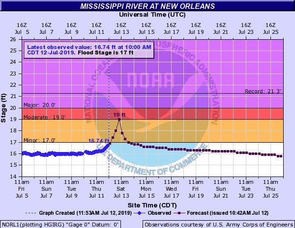
Barry may also drive a storm surge up the Mississippi River, which has been setting records for prolonged flooding upstream through much of this year. Taking into account the potential surge as well as rainfall, NOAA predicted on Friday morning that the river height at New Orleans could reach 19 feet on Saturday, whereas the levees protecting the city are at least 20’ high (as confirmed by the U.S. Corps of Engineers). A 19-foot crest would be the highest since Feb. 10, 1950. (As of Friday morning, the Mississippi was at 16.74’—already the highest level observed so late in a calendar year in records going back to at least 1828.)
 |
| Figure 2. Observed and predicted heights for the Mississippi River at Carrollton Gage near Audubon Park in New Orleans. Image credit: NOAA/NWS/AHPS. |
Some river levees south of Oakville and Caernarvon in Plaquemines Parish could be overtopped, according to the Corps, and intermittent overtopping could happen in or near the city due to wave action. With this in mind, it wouldn’t be a shock to see waters lapping over the levees at times in New Orleans even if no breaching or major overtopping were to occur (something to keep in mind as pictures and videos start to appear in social media).
Given the very rare juxtaposition of a late-season flood and an early-season tropical storm, the Mississippi will bear close watching this weekend. For more on this topic, see the nola.com article published Friday and Jeff Masters’ detailed look at how surge can affect the Mississippi in southeast Louisiana.
 |
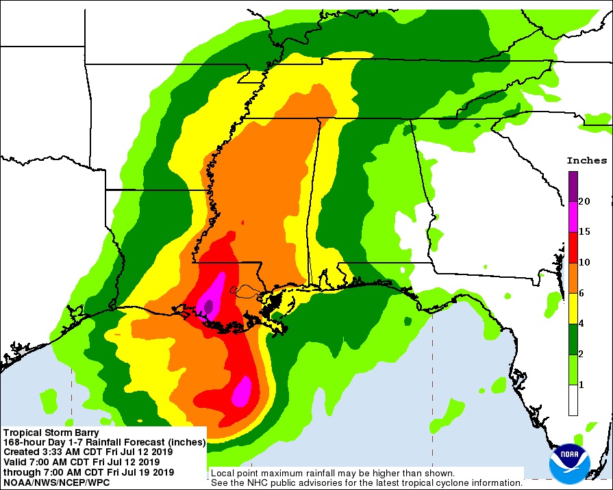
| Figure 3. Seven-day rainfall forecast from 8 am EDT Friday, July 12, 2019, to July 19. Image credit: NOAA/NWS/WPC. |
Mammoth amounts of rain headed for southern Louisiana and beyond
What appears near-certain is that the lower Mississippi Valley is in for a massive, potentially devastating rainfall event. From Saturday into Sunday morning, “significant flooding and life-threatening flash flooding are likely across eastern Louisiana and southwest Mississippi,” said the NOAA/NWS Weather Prediction Center in its Day 2 high-risk outlook for excessive rain.
According to WPC, the convective core now on Barry’s south side will gradually pivot around the surface center and push into southeast Louisiana on Saturday, a scenario depicted in multiple runs of the European model. The very heaviest rains, with a corridor of 10-15” amounts and pockets of 20-25” or more, are likely to be within the convective core just east of the surface center, most likely falling somewhere between Lafayette and New Orleans. Exactly how far to the east or west this corridor develops will be crucial to where the worst flooding impacts occur—and these details are still too far out to predict with confidence. Short-range models should give us a better sense starting Friday night of where the heaviest rainbands will set up. Even locations well outside the heaviest rain corridor will be prone to intense downpours and very dangerous flash flooding.
The "no-name" storm that hammered southeast Louisiana in August 2016 should serve as a reminder that a hurricane is not required for devastating floods in this area. Despite never being classified as a tropical cyclone, this slow-moving low deposited widespread rains of 20"+, including a storm total of 31.39" at Watson. Damages topped $10 billion, and 13 deaths were reported.
⚠️ 1240pm: Here is a closer look at a few of the area rivers. We are looking at potential for life-threatening flooding in some areas. Please pay attention to any forecast updates as these river forecasts are depending on where the heaviest rain falls. #lawx #mswx #Barry pic.twitter.com/RKND1W3ZJI
— NWS New Orleans (@NWSNewOrleans) July 12, 2019
By Sunday, a weakening Barry will take on more of a classic comma shape of a subtropical or mid-latitude storm system. Depending on how Barry evolves, extremely heavy rains could extend well north into Mississippi, with lesser but still-heavy amounts north of Barry's center from Arkansas into Missouri from Sunday into Monday. Soils are considerably wetter than usual toward northern Mississippi, which could exacerbate any flood threat there.
 |
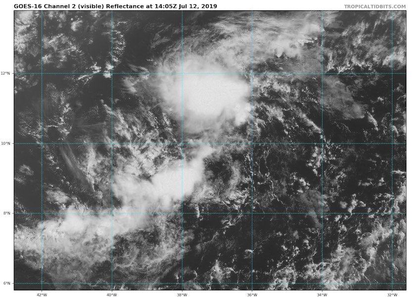
| Figure 4. Visible satellite image of 93L at 10:05 am EDT July 12, 2019. Image credit: tropicaltidbits.com. |
First tropical wave of 2019 worth watching: Invest 93L in Eastern Atlantic
The first tropical wave of 2019 worthy of attention (93L ) was located about 1000 miles west-southwest of the Cabo Verde Islands on Friday morning, and was headed west at 15 – 20 mph.
Satellite loops late Friday morning showed that 93L had plenty of spin, and small area of heavy thunderstorms that were gradually increasing in areal extent and growing more organized. The SHIPS model diagnosed light wind shear of 5 - 10 knots, and showed that the atmosphere surrounding 93L was quite dry, with a mid-level relative humidity of 45%. Sea surface temperatures (SSTs) were adequate for development, at 27°C (81°F). Overall, these conditions favor slow development.
Forecast for 93L
93L is caught up in a strong flow of easterly trade winds, and will continue to the west at 15 – 20 mph for the next five days. This will bring the disturbance into the Lesser Antilles Islands by Monday evening, and will also act to impede development, since fast-moving tropical waves have more difficultly aligning themselves vertically and getting organized.
As the system heads west, it will encounter even dryer air, as seen in the latest Saharan Air Layer Analysis. Though wind shear is predicted to be low to moderate and SSTs will be adequate for development, near 26.5 - 27°C (80- 81°F), this dry air will create hostile enough conditions that development into a tropical depression is unlikely over the next five days.
Approximately 20% of the 50 ensemble members of the 0Z Friday run of the European model showed 93L being a tropical depression on Monday as it moved through the Lesser Antilles. None of the GFS ensemble members showed development. In their 8 am EDT Friday Graphical Tropical Weather Outlook, the National Hurricane Center (NHC) gave 93L 2-day and 5-day odds of development of 20%.
We’ll have our next update on Friday evening.
Dr. Jeff Masters co-wrote this post.


