| Above: Infrared GOES-16 satellite image of Invest 93L as of 2117Z (5:17 pm EDT) Saturday, June 17, 2017. GOES-16 data are preliminary and non-operational. Image credit: MSFC NASA Earth Science Office. |
It’s not every June 17 that we have two potential tropical storms to monitor in the Atlantic basin. The NWS/NOAA National Hurricane Center (NHC) classified a tropical wave in the northwest Caribbean as Invest 93L on Saturday, which kicks off the process of tracking and forecasting the wave in greater detail. The newly christened 93L joined Invest 92L, which continues to slowly organize in the central tropical Atlantic.
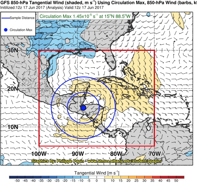
As of 2:00 pm EDT, the center of low pressure associated with 93L was located over the Gulf of Honduras just north of the coastline, moving slowly northwest. The broad circulation of 93L is a good example of a Central American gyre, a weak, sprawling cyclone that can deliver torrential rains and lead to catastrophic flooding. A gyre-analysis page from Philippe Papin (SUNY Albany) shows that the circulation of 93L extends across Central America to the Pacific. Papin reported on Saturday that 93L satisfies the criteria for a Central American gyre that he and colleagues recently developed. Each year typically brings one or two of these gyres, most often in May-June or September-November.
 |
| Figure 1. Tangential (rotational) component of the winds at 850 mb (about a mile above sea level) spinning around the large gyre associated with Invest 93L as of 8:00 am EDT Saturday, June 17, 2017. Image credit: Philippe Papin/SUNY Albany. |
It can be difficult for a gyre-type circulation to consolidate into a more compact tropical cyclone, since it takes a long time to get such a large mass of air spinning more rapidly. However, guidance from multiple models has been quite consistent for several days in bringing 93L to at least tropical depression strength after it crosses the Yucatan Peninsula later this weekend and moves into the southern Gulf of Mexico. In its 2:00 pm outlook, NHC gives 93L a 30% chance of becoming at least a depression by Monday and an 80% chance by Thursday, an increase from near-0% and 60% in yesterday morning’s outlook.
Once it enters the Gulf, 93L will have a reasonable shot at becoming a tropical storm—either Bret or Cindy, depending on the timing and evolution of 92L (see below). Sea surface temperatures are as much as 1°C above average in the Bay of Campeche, but up to 1°C below average in the north central Gulf. This means the usual north-to-south temperature gradient is a bit stronger than usual. The SSTs will range from 26.5°C to 29°C (80 – 84°F), which is adequate for tropical cyclone development, especially toward the south. 93L will experience increasing southerly wind shear as it moves into the Gulf of Mexico, which should serve as a brake on any rapid intensification.
 |
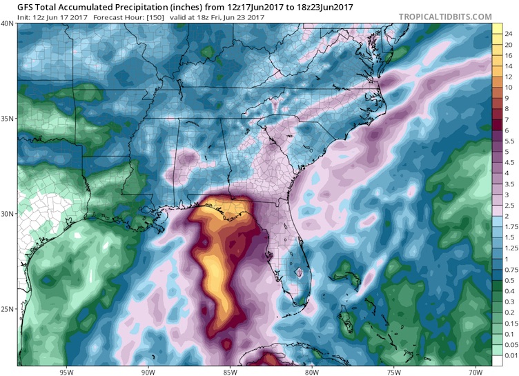
| Figure 2. The 12Z Saturday run of the GFS model, which brings 93L slowly onshore along the central Gulf Coast, predicts a corridor of 12” – 16” of rainfall over the Florida Panhandle. It is still too early to know if 93L will move this slowly, and it might instead move toward Texas or Mexico as suggested by the European model. Image credit: tropicaltidbits.com. |
Extremely heavy rains may accompany 93L inland
Models agree that 93L is unlikely to become a hurricane, but the system is large and moist and will be capable of producing extremely heavy rain. There remains considerable disagreement on where this potential depression or tropical storm will track. The ECWMF and its ensemble members have been fairly consistent in tracking 93L over or around the Yucatan Peninsula and toward the western Gulf, where it would make landfall in South Texas or Mexico. The 12Z Saturday ECMWF run brings the center near Brownsville on Thursday, most likely as a weak tropical storm.
The GFS has shown less internal consistency, but it has tended to track 93L toward the central Gulf Coast, in response to a more vigorous upper-level trough in the GFS moving through the eastern U.S. The 12Z Saturday run of the GFS brings 93L inland near Mobile, AL, after several days of slow motion just offshore. A slowdown in forward speed would be plausible given the departure of the eastern trough and the weakening of steering currents. If 93L does move as gradually as shown by the GFS, we can expect torrential rains—perhaps 10” to 20”—somewhere along the central Gulf Coast, regardless of whether 93L is a wave, depression, or named storm. Likewise, torrential rain could be expected over South Texas if the ECMWF is correct, although the amounts would probably be less than for the GFS track given that 93L would likely be moving at a more steady clip around the intense dome of high pressure producing record heat in the Southwest U.S.
Starting tonight, we will get regular guidance from the HWRF model for 93L, which should help clarify where the system is heading next week and how strong it might be. Residents along the Caribbean coast of Belize and Mexico, as well as western Cuba, should be prepared for very heavy rainfall over the next 48 hours.
 |
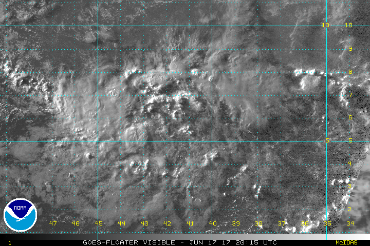
| Figure 3. Thunderstorms can be seen bubbling in this satellite image of Invest 92L near sunset (2015Z or 4:15 pm EDT) Saturday, June 17, 2017. Image credit: NOAA/NESDIS. |
92L likely to threaten the southern Windwards early next week
The tropical wave known as Invest 92L continued chugging through the tropical Atlantic on Saturday. There is an increasing amount of spin evident on satellite around 92L, but ASCAT scatterometer data on Saturday afternoon failed to show a closed low-level center of circulation, and showers and thunderstorms (convection) remained scattered and disorganized around 92L. The usual nighttime peak in tropical convection could give 92L a boost tonight and/or Sunday night.
Wind shear over 92L will be light (less than 10 knots) through Monday, and the system will be passing over warm SSTs of around 29°C (84°F) and through a moist atmosphere (mid-level relative humidity around 60 - 70%). All of these signs point toward a good chance of 92L organizing into a depression and perhaps a tropical storm by Monday. As of Saturday afternoon, NHC gave the system a 40% chance of becoming at least a depression by Monday and a 60% chance by Thursday, compared to the 20% and 40% odds given on Friday.
Models are in close agreement on a fairly straightforward track for 92L, which should pass near the coast of Venezuela or the southern Windward Islands on Tuesday or Wednesday. The ECMWF ensemble continues to lean toward 92L being a depression moving very close to South America, while the GFS ensemble members predict a tropical storm slightly to the north. The 12Z run of the HWRF model—among the most reliable for intensity—makes 92L a minimal hurricane as it passes the islands, although we should wait for the system to develop a closed circulation before we trust any model's intensity forecast. Islanders as far north as St. Lucia and Barbardos should keep an eye on 92L, as it may end up with a compact circulation that could intensify more quickly than models expect it to, especially if it takes a more west-northwest tack.
Models continue to agree that 92L will very likely degenerate on its trek across the Caribbean, as increasing wind shear and diverging surface winds—hallmarks of the early-summer eastern Caribbean “graveyard”—take their toll on the system.
We’ll be back with our next update by Sunday afternoon.


