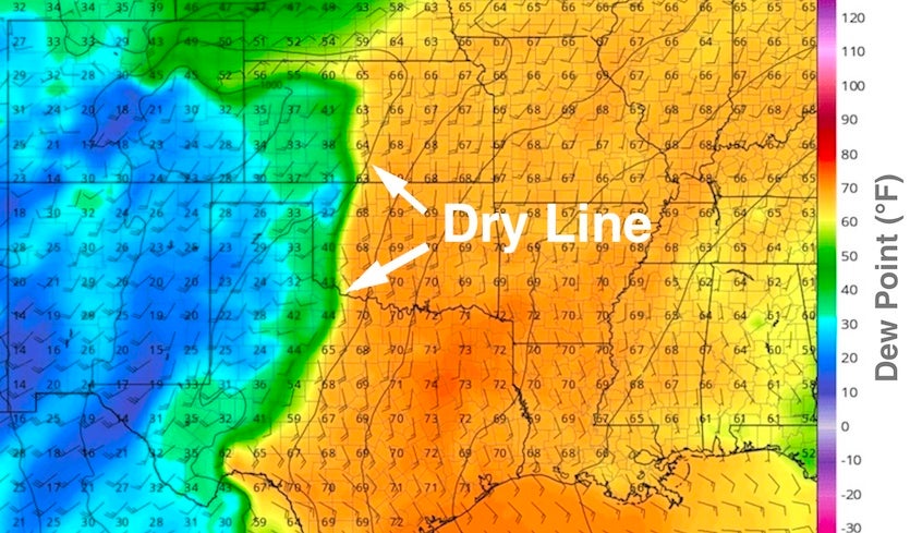
| Above: For much of this week, a dry line across the Southern and Central Plains will separate hot, dry air to the west from warm, moist, unstable air to the east. Shown here is the dry line location as predicted by the 12Z Monday run of the GFS model for 7 pm CDT Wednesday, May 2, 2018. The numbers denote the surface dew point (degrees °F); higher dew points indicate more moisture in the air near the surface, which tends to produce greater instability. Surface winds are shown by the wind flags and barbs, with strong southerly flow pulling moisture from the Gulf of Mexico into the Southern Plains. Image credit: tropicaltidbits.com. |
The month of May produces more U.S. tornadoes than any other, on average, and severe weather will be ramping up accordingly as May 2018 kicks off. A slow-moving upper-level trough and surface front will trigger multiple days of severe thunderstorms across the Southern and Central Plains, shifting toward the Mississippi Valley by late in the week.
May is typically a transition period between the strong jet streams of early spring—which often keep severe storms shunted toward the Deep South—and the weaker jet streams of late spring, which allow for more-widespread rounds of severe weather across the central and eastern U.S., and a gradual shift from tornadic supercells to torrential rainmakers. It’s during May that a strong jet stream and the presence of ample Gulf moisture most often coincide, producing the greatest threat of tornado outbreaks. This happens most often across the classic Tornado Alley region of the Southern/Central Plains, from Texas northward into Nebraska and Iowa.
 |
| Figure 1. Oklahoma is Ground Zero for U.S. tornadoes in early May, as shown in this climatological portrayal for May 6 of the most frequent tornado occurrence across 80-by-80-kilometer grid boxes, valid for the period from 1981 through 2011. Image credit: NOAA/NWS/SPC. |
Slow-moving upper lows often set up across the Southwest during May as the jet stream begins to weaken. This can lead to storm-friendly wind shear and a string of multiple severe weather days downstream across the Plains—often with at least one day of widespread supercells before the low “lifts out” and the strongest upper winds pass by.
The pattern on tap this week bears many of the hallmarks of the May prototype. The southern end of an upper-level trough over the northwest U.S on Monday will break off into an upper low near Las Vegas by Wednesday, then lift out from Thursday into Friday. It doesn’t look like there will be a strong “negative tilt” wave with divergent upper-level winds—which is the set-up associated with the most intense, widespread tornadic supercells—so right now I’m not expecting to see the NOAA/NWS Storm Prediction Center issuing a high-risk outlook. Still, we’re likely to see dozens of twisters before the week is out, and there is the risk of one or more strong tornadoes, especially on Tuesday and/or Wednesday.
 |
| Figure 2. WU depiction of severe weather risk areas as designated at midday Monday, April 30, by the NOAA/NWS Storm Prediction Center for Days 1, 2, and 3 (left to right), or Monday, Tuesday, and Wednesday, April 30-May 2, 2018. The orange areas for Tuesday and Wednesday denote an enhanced risk of severe weather, the third-highest of SPC’s five risk categories. |
The day-by-day outlook
Monday: Moisture was just returning to the Southern Plains on Monday morning, with dew points of around 55°F streaming into central Kansas and western Oklahoma. That’s roughly the minimum value for producing classic severe weather, and the moisture isn’t likely to get much richer until late Monday. Ample upper-level energy moving into the Southern Plains should be enough to produce scattered late-day severe storms from South Dakota to western Texas ahead of a sharpening dry line. Large hail will be the main threat.
It’s possible that richer moisture will arrive in the eastern Texas Panhandle late in the day, just in time to generate a couple of more intense supercells. If so, strong vertical wind shear and cold air aloft would allow for very large hail and perhaps several tornadoes.
Tuesday: The environment is expected to be more volatile on Tuesday across western Oklahoma, central and northeast Kansas, and southeast Nebraska, with the dry line pushing slowly eastward and ample moisture in place (dew points should be in the 60-65°F range). A surface low in southeast Colorado should extend to a “triple point” in central Kansas, where the dry line will intersect a nearly stationary front. Any tornado-producing supercells would be most likely to form near the triple point, eastward along the stationary front, and/or south along the dry line.
There will be no strong upper-level wave to kick off storms on Tuesday, and weakly subsiding air will tend to produce a warm, dry mid-level “cap” and suppress development—especially toward southern parts of the risk area—so thunderstorms are not expected to be widespread. However, both wind shear and instability will be more than adequate for tornadic storms, so any supercells that do develop could be formidable.
 |
| Figure 3. The forecast issued by the 12Z Monday run of the GFS model, valid at 7 pm CDT Tuesday, May 1, shows a strong upper-level trough in the western U.S. (green colors) at the 500-millibar level (about 19,000 feet). Colors show the height of the 500-millibar pressure surface, in decameters. Also shown are the surface pressure features, including a strong surface low in southeast Colorado and a front extending northeast into Iowa. Image credit: tropicaltidbits.com. |
Wednesday: As the upper low in the Southwest begins to lift out, the southwesterly jet stream will intensify and the dry line will push a bit further east. Upper-level forcing is likely to produce more widespread storm coverage than on Tuesday, and intense supercells with tornadoes will again be possible. The activity will likely transition by late Wednesday into one or more strong mesoscale convective complexes from Iowa to Texas. Wednesday’s storm modes will depend in part on how storms evolve Tuesday evening and what kind of environment they leave behind.
Thursday: Another day of widespread severe weather is possible. The key features will be largely unchanged but focused just a little further east, most likely extending from eastern Texas and Oklahoma into Arkansas and Missouri. Again, the previous day’s activity will play a big role in determining how and where storms develop on Thursday.
Will Oklahoma’s record “tornado drought” come to an end this week?
As a native Oklahoman, it’s hard for me to believe the state has made it to the end of April without a single tornado being reported. In fact, we are now in uncharted territory. In official records dating back to 1950, this is the latest Oklahoma has gone without its first reported tornado in a given year. The previous record of April 26 occurred in 1962, as reported by weather.com’s Linda Lam and Brian Donegan.
Given the swarms of tornado spotters and chasers that now blanket Oklahoma, and the near-ubiquitous presence of smartphone cameras, the lack of any reported twisters for 2018 is even more impressive.
It’s been a quiet tornado season in Kansas as well, with no tornadoes reported there through April 30. The only three years with a later start to the Kansas tornado season have been 1962, 1967, and 1980, with the brutal drought year of 1980 as the record-holder (May 28).
Chilly temperatures, limited moisture, and unfavorable upper-level patterns have all conspired to keep tornadoes out of Oklahoma and Kansas this spring. Many parts of the central and eastern U.S. are on track to close out this month as one of their top three coldest Aprils on record. In line with the widespread chill, the tornado season has been on the quiet side for the nation as a whole. The “inflation-adjusted” total of 230 reported twisters through April 29 compares to a typical year up to that date of 321, with the busiest year producing 559 and the quietest producing 118. (The inflation adjustment brings more recent years in line with earlier years that lacked the density of storm reporting we have now.)
On average, the number of miles carved out each week by tornado paths across both Oklahoma and Kansas increases dramatically once we get into May, as shown in the tweets below by independent tornado researcher Thomas Grazulis.
REDONE OKLAHOMA CHASE SEASON. Quick rise at end of April and quick fall at end of May with peak in the first week of May. KS follows below, then NE next week. Dakotas in late April .. Worst KS kt list does not have May 20, 1957 7k in KS, 37 in MO from the same tornado. pic.twitter.com/N0zXbfLifP
— Thomas Grazulis (@sigtor2019) April 4, 2018
KANSAS CHASE SEASON -- Quick rise one week after after Oklahoma with some extension into June, and drop off on July 1st. Next graph shows no serious March activity for pre-1950, and a later peak This is not from poor documentation. pic.twitter.com/aP62SSaMTk
— Thomas Grazulis (@sigtor2019) April 4, 2018
As things stand now, I’d put better-than-even odds on the tornado droughts of both Oklahoma and Kansas getting broken by Friday, May 4, if not sooner.
Just as with hurricane “droughts”, it’s critical to keep in mind that it only takes a single tornado to change a quiet year into a devastating one. It’s especially important to remember what the peak of climatological tornado season can produce, as spotlighted in a weather.com retrospective on the harrowing Joplin tornado of May 22, 2011. The article’s title speaks for itself: “One Tornado, 158 Dead, 75 Percent of City Destroyed.”
 |
| Figure 4. Maddie Meek and her mother Dina Meek salvage what they can from a relative’s home after it was destroyed by a massive tornado that struck on May 22, 2011 in Joplin, Missouri. Image credit: Joe Radle/Getty Images. |


