| Above: MODIS image of 95L taken on Sunday morning, July 16, 2017. A large area of Saharan dust is apparent as brown colors to the north and northeast of the disturbance. Image credit: NASA. |
A tropical wave located at 8 am EDT Sunday near 11°N, 44°W, about 1000 miles east-southeast of the Lesser Antilles Islands, was headed west to west-northwest at about 15 mph, and was designated 95L by NHC on Sunday morning. This system has the potential to develop into a tropical depression or weak tropical storm by the time it arrives in the Lesser Antilles Islands on Wednesday.
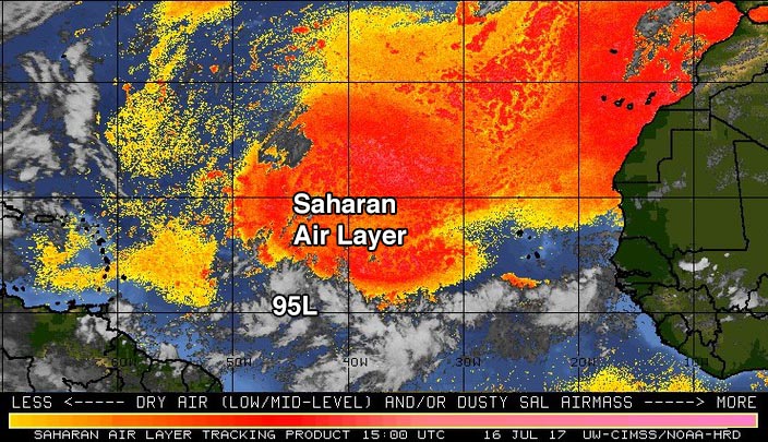
Satellite images on Sunday morning showed that 95L was very disorganized, with little spin and only a modest amount of heavy thunderstorm activity. Development was being retarded by dry air, thanks to the presence of the Saharan Air Layer (SAL) just to the north (Figure 1). Wind shear was low to moderate, 5 – 15 knots, and sea surface temperatures (SSTs) were warm enough for development, near 27.5°C (82°F)--about 1°F above the seasonal norm.
 |
| Figure 1: The Saharan Air Layer (SAL) analysis from 11 am EDT Sunday, July 16, 2017, showed a large area of dry Saharan air in the tropical Atlantic north of Invest 95L. Image credit: University of Wisconsin CIMSS/NOAA Hurricane Research Division. |
Forecast for 95L
The main impediment for development over the next three days will be the presence of the dry air to the system’s north. Also, the Madden-Julian Oscillation (MJO), a periodic pulse of thunderstorm activity that circles equatorial regions of the globe every few weeks, is not in a phase that will help development of Atlantic tropical cyclones this week. Otherwise, conditions are favorable for development: wind shear should be light to moderate, and SSTs will be 27.5 - 28°C (82°F). In their 8 am EDT Sunday Tropical Weather Outlook, the National Hurricane Center (NHC) gave 95L 2-day and 5-day odds of tropical cyclone development of 20% and 40%, respectively.
The operational versions of our three top models for predicting tropical cyclone genesis--the European, GFS and UKMET--did not show development of the system over the next five days. However, 65% of the 20 members of the 0Z Sunday GFS ensemble forecast did predict development. Only about 10% of the 50 members of the 0Z Sunday European model ensemble forecast did so, though. None of these forecasts had 95L becoming a hurricane, and the vast majority of the forecasts showed the storm only becoming a tropical depression or weak tropical storm by mid-week, then dying out in the Eastern Caribbean late in the week. At that time, the 12Z Sunday run of the SHIPS model was predicting that 95L would see very high wind shear of 25 – 40 knots, and the Eastern Caribbean is notoriously hostile to tropical cyclones, especially this early in the season.
The models had a strong ridge of high pressure steering the system west to west-northwest at about 15 mph for the next five days, which would bring the storm to the Lesser Antilles Islands on Wednesday and into the Eastern Caribbean by Thursday. The next name of the Atlantic list of storms is Don.
 |
Hurricane Fernanda at 5:42 pm EDT Saturday afternoon, July 15, 2017, as seen by the VIIRS instrument on the Suomi satellite. At the time, Fernanda was a Category 4 storm with 135 mph winds. Image credit: NASA. |
Category 4 Hurricane Fernanda still impressive
After going through an eyewall replacement cycle that reduced it to a Category 3 storm early Sunday morning, Hurricane Fernanda in the Eastern Pacific was back up to Category 4 strength late Sunday morning after completing the cycle. Fernanda will be over warm waters with light wind shear until Monday afternoon, which may allow for additional intensification. Thereafter, Fernanda will be on a gradual decline, as it moves over cooler waters and into a drier, more stable atmosphere. The weakening should be gradual, though, and it’s possible that Fernanda will be approaching the Hawaiian Islands as a weak tropical storm or tropical depression by Saturday, July 22.
Greg on the way in the East Pacific?
A new system in the East Pacific, Invest 97E, could become a long-lived tropical storm in the coming days well southwest of Mexico. In their 8 am EDT Sunday Tropical Weather Outlook, The National Hurricane Center gave 97E a 50 percent chance of becoming at least a tropical depression by Tuesday, and a 70 percent chance by Friday. Starting off at a higher latitude than Eugene and Fernanda, this next system—which will be named Greg if it develops—will be traversing cooler waters and is unlikely to become a significant hurricane as it tracks far out to sea. Another Eastern Pacific disturbance, 98E, was located about 800 miles south-southwest of the southern tip of the Baja peninsula, was being given 2-day and 5-day odds of development, respectively. 98E is also no threat to land.


