| Above: Projected track of PTC 7 as of 5:00 pm EDT Sunday, August 6, 2017. Image credit: NOAA/NHC. |
Tropical storm warning flags are flying for the Yucatan Peninsula, with a tropical storm watch for the Belize coast, as Potential Tropical Cyclone 7 could become a named storm before it sloshes ashore late Monday. Models agree the system will likely strengthen more dramatically in the Bay of Campeche before an expected second landfall later this week in northeast Mexico.
The NOAA/NWS National Hurricane Center (NHC) upgraded the wave known as Invest 90L to PTC 7 at 5:00 pm EDT Sunday. The new “potential tropical cyclone” designation, which was introduced this year, tracks systems that are not yet tropical storms but that could affect land as tropical storms within 48 hours.
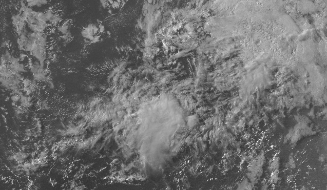
ASCAT scatterometer data at midday Sunday showed that easterly winds of around 30-35 mph extended across a broad zone north of PTC 7. NHC placed the center of this broad low-level circulation about 90 miles east of the northeast tip of Honduras as of 5:00 pm EDT Sunday, moving west-northwest at about 15 mph. The system remained quite asymmetric, with westerly winds weak to nonexistent on its south side. Satellite imagery showed widespread but still poorly organized showers and thunderstorms (convection), with little spin evident. Westerly upper-level winds feeding into a large upper low north of Puerto Rico have imparted strong wind shear (15-25 knots) to the eastern part of PTC 7, with additional shear being produced by a small upper low north of Honduras.
 |
| Figure 1. Infrared GOES-16 image of PTC 7 as of 2015Z (4:15 pm EDT) Sunday, August 6, 2017, when the system was still designated as Invest 90L. Image credit: NASA/MSFC Earth Science Branch. |
Outlook for PTC 7: Two landfalls are likely
Despite PTC 7’s less-than-textbook appearance on Sunday, there are strong signals that the wave will become a tropical storm before it moves west-northwest into the coast of Belize or Mexico’s Yucatan Peninsula late Monday. The wave is heading into a part of the far northwest Caribbean with unusually deep warm water. Sea surface temperatures, or SSTs, are close to 29°C (84°F), more than 1°C above average. Moderate wind shear of 10-15 knots is predicted to slacken below 10 knots by Monday, and the atmosphere around PTC 7 will remain very moist, with mid-level relative humidities around 70%. In its 2:00 pm EDT tropical weather outlook, NHC gave PTC 7 an 80% chance of becoming at least a tropical depression by Tuesday afternoon and a 90% chance through Friday.
The 12Z Sunday run of the HWRF model, our best short-term intensity guidance, shows PTC 7 becoming a strong tropical storm before a landfall in Mexico's Quintana Roo state on Monday evening. The 12Z runs of the GFS, European, and UKMET models agree on this general track, though without as much intensification. Given PTC 7’s current lack of organization, I would peg its most likely strength at landfall as a weak tropical storm. Heavy rains across the region should be the main threat.
The second chapter of PTC 7’s saga will unfold after it crosses the Yucatan Peninsula. The low-lying, water-surrounded terrain of the peninsula should dent PTC 7’s strength only slightly, especially since the system may still be loosely organized at that point. Global models have come into stronger agreement on a track that would keep PTC 7 moving west-northwest through the Bay of Campeche from Tuesday to Thursday, when it will likely reach the northeast coast of Mexico. The Bay of Campeche is a notoriously favorable area for tropical development, with very warm waters and a concave topography that helps focus storm spin. Models suggest that 99L will be angling leftward as it moves through the bay, which would impart further cyclonic spin and could also hasten intensification.
Growing support for #90L to reach Hurricane intensity later this week, putting Mexico at a higher risk for a landfalling hurricane. pic.twitter.com/uAZpPdczqb
— Michael Ventrice (@MJVentrice) August 6, 2017
The official NHC outlook from 5 pm EDT Sunday brings PTC 7 into the coast of northeast Mexico as a strong tropical storm. If PTC 7 enters the bay with a low-level circulation, I would give better than 50-50 odds that it will reach northeast Mexico as a hurricane. The 12Z HWRF suggests that rapid strengthening is possible from Wednesday until a Thursday landfall as a strong Category 2 storm, and the Rapid Intensification index in the 18Z SHIPS model gives a 62% chance that PTC 7 will be a 95-knot hurricane (top-end Category 2) by late Wednesday. Although our three top global models show less strengthening, the HWRF and SHIPS scenario is a real possibility.
 |
| Figure 2. Visible satellite image of Invest 99L as of 1945Z (3:45 pm EDT) Sunday, August 7, 2016. Image credit: NOAA/NESDIS. |
Little change with 99L in the central Atlantic
The wait-and-see game continues with Invest 99L, a large tropical wave rolling through the central Atlantic midway between Africa and the Lesser Antilles. 99L has shown little inclination to organize over the last several days, and it remains quite elongated as it pushes west-northwest at about 15 mph.
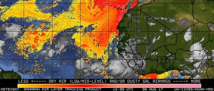
The strong zone of high pressure in the central Atlantic pushing 99L westward is also leading to subsidence and drying, and this dry air will be a thorn in 99L’s side. The wave will be encountering a large extension of the Saharan Air Layer (see Figure 3 below) over the next couple of days. The 18Z SHIPS model shows mid-level relative humidities around 99L will drop from around 60% to around 55% from Monday onward. Moderate wind shear of 10-15 knots, increasing to 15-20 knots by Tuesday, may also impede 99L’s growth.
In its 2:00 pm EDT tropical weather outlook, NHC gave 99L an 20% chance of becoming at least a tropical depression by Tuesday afternoon and a 50% chance through Friday.
 |
| Figure 3. A patch of the Saharan Air Layer (SAL) lies ahead of 99L west-northwest track over the next several days. Image credit: UW-CIMMS/NOAA Hurricane Research Division. |
The leading global models have come into closer agreement on 99L’s fate, which seems most likely to be unimpressive but with a small chance of U.S. impacts more than a week from now. Of the ensemble runs from 0Z Sunday, less than 20% of the 50 European model members led a tropical storm near or just north of the Leeward Islands by Wednesday. A small fraction (less than 10%) continued 99L on a northwestward track that had the system approaching the U.S. East Coast as a tropical storm or hurricane around 7 to 9 days from now. As in past days, the GFS model was more bullish on 99L, with about two-thirds of its 20 ensemble members producing a tropical storm and about 25% carrying the system toward Florida and/or the Gulf of Mexico as a tropical storm or hurricane by next weekend. The operational UKMET model from 0Z Sunday suggested the potential for an East Coast system, while the operational GFS and ECMWF runs did not develop 99L significantly through 7 days.
There is plenty of time to see if 99L manages to organize as it approaches the Leeward Islands. Based on the trend of global models, 99L or its remnants will ultimately head toward the United States. We may need to keep at least one eye on 99L even if it approaches the U.S. as a weak system, since rapid spin-ups are possible in the Bahamas and Gulf of Mexico this time of year.
 |
| Figure 4. Infrared/visible image of Typhoon Noru at 1830Z (2:30 pm EDT) Sunday, August 6, 2017. Image credit: CIMMS/University of Wisconsin. |
At least 2 killed by Typhoon Noru, now heading across Japan
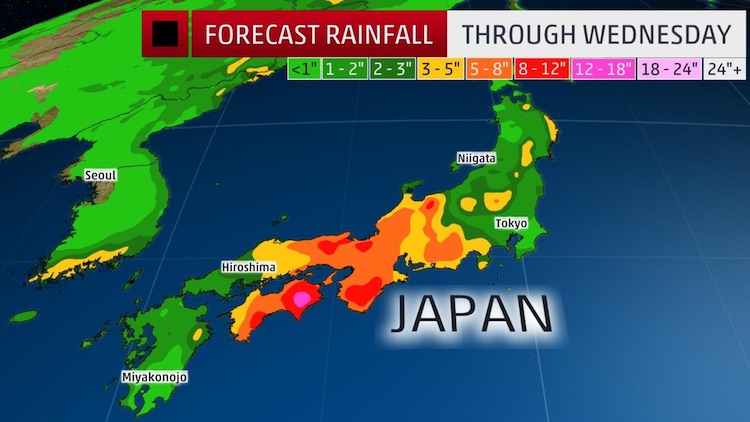
Two deaths have been reported as a result of Typhoon Noru, a Category 1 storm that will grind its way northeast along the Japanese archipelago over the next several days. More than 200,000 people have been evacuated along parts of Kyushu, Japan’s southernmost large island, according to Reuters and the Japan Times. Although Noru will gradually weaken due to interactions with land, the Japan Meteorological Agency has large portions of the country under warnings for gales, heavy rains, high winds, and possible landslides.
 |
| Figure 5. Large parts of southern and central Japan will see heavy rains as a result of Typhoon Noru. Image credit: The Weather Channel. |


