| Above: Tropical Storm Irma as seen on Wednesday morning, August 30, 2017, from a composite of the MODIS images from NASA's Terra and Aqua satellites. |
Tropical Storm Irma formed on Wednesday morning in the far eastern Atlantic, and has the potential to become a dangerous long-track Cape-Verdes-type hurricane. Satellite images on Wednesday afternoon showed that Irma was well-organized, with plenty of heavy thunderstorms, impressive low-level spiral bands, and an upper-level outflow channel to the south. Conditions were favorable for development, with sea surface temperatures (SSTs) near 27.5°C (82°F), light wind shear of 5 -10 knots, and a moist surrounding atmosphere with a mid-level relative humidity of 70%.
Intensity forecast for Irma
For the next five days, wind shear was predicted to be very favorable for development--a low 5 – 10 knots--according to the 18Z Wednesday run of the SHIPS model. Irma will begin moving into a drier region with cooler sea surface temperatures beginning on Thursday. Friday through Sunday, it’s expected SSTs will be 26.5 – 27.5°C (80 - 82°F), and the mid-level relative humidity will be 50 – 55%--conditions that are marginal for development. If Irma can build an inner core and intensify into a hurricane before Friday, it may be able to shrug off these marginal conditions without serious difficulty, though. Early next week, when Irma will be approaching the Lesser Antilles Islands, SSTs will warm considerably with a major increase in total heat content. The atmosphere is also predicted to be moister with low shear, so increased strengthening is likely. Three of our most reliable intensity models, the HWRF, LGEM, and DSHIPS, predicted in their 12Z and 18Z Wednesday runs that Irma would be a major Category 3 hurricane with 115 mph winds by Monday, and I think this is a reasonable forecast.
Track forecast for Irma
Irma will head generally west at about 10 - 15 mph through Friday, then assume a more west-southwesterly track over the weekend, as the ridge of high pressure steering the storm builds to the southwest. This would potentially bring Irma into the Lesser Antilles Islands as early as Tuesday night, September 5, as predicted by the 12Z Wednesday run of the European model. The GFS model was much less concerning, with its 12Z Wednesday run predicting that a strong trough of low pressure would turn Irma to the northwest early next week, resulting in the storm missing the Lesser Antilles Islands by more than 500 miles. It is too early to pick a solution, since 7-day hurricane forecasts are of extremely low reliability.
New tropical depression possible in the Gulf of Mexico next week
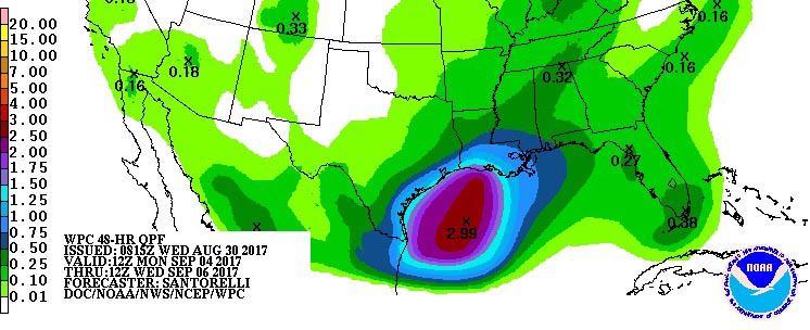
Residents of the water-weary Texas and Louisiana coasts will need to keep an eye toward the Gulf of Mexico next week, as multiple computer model runs show the possibility of another tropical cyclone developing somewhere in the western Gulf early next week. The potential is reflected in the 7-day precipitation forecast from the NOAA/NWS Weather Prediction Center, which shows an area of 3-5” rains in the western Gulf (see Figure 1).
The most likely scenario at this point is--if something does develop--a tropical depression or weak tropical storm moving slowly across the western Gulf. The 12Z Wednesday run of the GFS model predicts that the storm could be a threat to the U.S. Gulf Coast, including Texas and Louisiana, late next week. In contrast, the 12Z Wednesday run of the European model kept the storm bottled up in the Bay of Campeche, with impacts primarily to Mexico. If a storm does develop and pushes towards Texas, it will encounter cooler waters churned up by Harvey, which will tend to dampen intensification. In their Tropical Weather Outlook issued at 2 pm EDT Wednesday, the National Hurricane Center gave next week’s potential Gulf tropical depression 2-day and 5-day odds of development of 0% and 20%, respectively.
 |
| Figure 1. Two-day rainfall forecast from 8:00 am CDT Monday, September 4, 2017, to 8:00 am Wednesday, September 6. Image credit: NOAA/NWS/WPC. |
Bob Henson contributed heavily to this post.


