| Above: GOES-16 infrared satellite image of Tropical Storm Franklin as of 1615Z (12:15 pm EDT) Monday, August 7, 2017. GOES-16 data are preliminary and non-operational. Image credit: NASA/MSFC Earth Science Branch. |
Steadily gathering strength in the northwest Caribbean, Tropical Storm Franklin is on course to strike the eastern coast of the Yucatan Peninsula on Monday night. Franklin could undergo a brief period of rapid intensification that makes it a hurricane just before landfall. At 11 am EDT Monday, a hurricane watch and a tropical storm warning were in effect for the Mexican coast from Chetumal to Punta Allen. Additional parts of the Yucatan coast of Mexico and Belize were under tropical storm watches or warnings.
After days as a loosely organized tropical wave rolling through the Caribbean, Franklin began consolidating on Sunday and became a tropical storm on Sunday night. At 2 pm EDT Monday, the NOAA/NWS National Hurricane Center was locating the center of Franklin at about 185 miles east of Belize City, with top sustained winds up to 60 mph. A large shield of intense thunderstorms covered the area near and to the north and east of Franklin’s center, with increasing upper-level outflow evident on the fringes of this shield. A Hurricane Hunter flight found winds of 48 knots at flight level well northeast of Franklin’s center at 12:44 pm EDT Monday, with the center located just south of a small dry slot evident in satellite imagery.
 |
| Figure 1. GOES-16 visible-wavelength satellite image of Hurricane Franklin as of 1600Z (noon EDT) Monday, August 7, 2017. Satellite loops show that the feature resembling an eye is most likely a dry slot wrapped just north of the main center of circulation, rather than a true eye. Image credit: NASA/MSFC Earth Science Branch. |
Outlook for Franklin
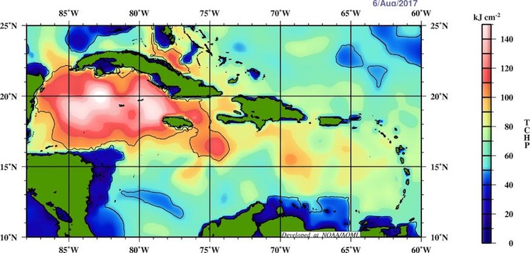
Conditions are very supportive of further growth in the few hours before Franklin makes landfall on Monday night, especially now that the storm is organized enough to take advantage of the favorable set-up. Wind shear will drop below 10 knots by Monday afternoon, according to 12Z Monday output from the SHIPS statistical model. Sea surface temperatures of 29-30°C (84-86°F) are about 1°C above average for this time of year, and Franklin is passing across an area of deep oceanic heat content, which lowers the odds that strong winds will bring cooler water to the surface.
 |
| Figure 2. Tropical cyclone heat potential (TCHP) across the Caribbean Sea as of Sunday, August 6, 2017, in kilojoules per square centimeter. TCHP integrates the amount of heat through the depth of the upper ocean as measured by temperatures at each level. The red and white zone across the northwest Caribbean is associated with hurricane-supportive water temperatures of at least 26°C (79°F) that extend more than 125 meters (410 feet) deep. Image credit: NOAA/AOML. |
Although it is not shown in the official NHC forecast (Figure 3 below), it is quite possible that Franklin will become a Category 1 hurricane just before landfall, between the forecast points at 7 pm EDT Monday and 7 am EDT Tuesday. If so, it will be the first Atlantic hurricane of 2017. In records going back to 1851, only four other years have seen six Atlantic tropical storms or hurricanes by August 6, according to Phil Klotzbach (Colorado State University). Those years are 1936, 1959, 2005, and 2012.
Torrential rain should be the main threat from Franklin, although gale-force winds may extend more than 100 miles up the coast from where Franklin makes landfall on the Yucatan Peninsula.
| Figure 3. WU depiction of the official NHC forecast for Franklin as of 11:00 am EDT Monday, August 7, 2017. |
Computer models are in very close agreement on Franklin’s track, which will make a gentle leftward arc across the Yucatan Peninsula and the Bay of Campeche. Franklin will exit the peninsula in a weakened state, though still likely a tropical storm. Although it is not shown on the tracking map—because it would occur between forecast points—Franklin may have a second brief chance at rapid intensification to hurricane strength just before it makes landfall on the northeast coast of Mexico well south of Tampico. The concave topography of the Bay of Campeche helps impart spin to tropical cyclones, and water temperatures will again be very warm, although the oceanic heat content is less than in the northwest Caribbean.
The last several runs of the HWRF model—our best short-term guidance for tropical cyclone intensity—have been consistent in bringing Franklin to northeast Mexico late Wednesday night as a Category 1 hurricane.
A good analog for Franklin is 2012’s Hurricane Ernesto, which became a tropical storm several days before approaching the Yucatan on a very similar track to Franklin’s—and on the same day of the year to boot (see embedded tweet below from Brian McNoldy). Ernesto quickly strengthened to Category 2 intensity just before landfall on the coast of Mahahual, Mexico. Ernesto failed to regain hurricane status after passing over the Bay of Campeche, but Franklin’s track is expect to be far enough north of Ernesto’s to give it more time over the bay’s warm waters without direct interference from land.
A major déjà vu moment: Tropical Storm #Franklin is following in the footsteps of Hurricane Ernesto from 2012... almost down to the hour! pic.twitter.com/TCBD2iUMpO
— Brian McNoldy (@BMcNoldy) August 7, 2017
 |
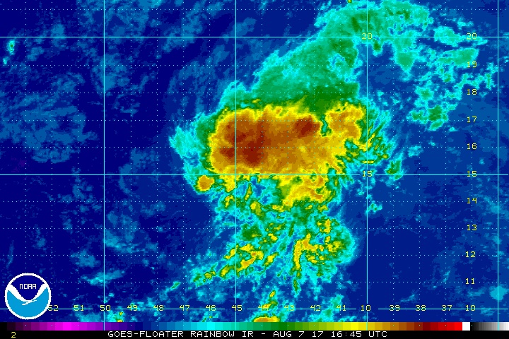
| Figure 4. Enhanced infrared image of Invest 99L as of 1645Z (12:45 pm EDT) Monday, August 7, 2017. Image credit: NOAA/NESDIS. |
99L: No worries for the time being
The long-struggling tropical wave in the central Atlantic known as Invest 99L continues to persevere, but its long-term future remains highly uncertain. Dry air from the Saharan Air Layer, and moderate to strong wind shear of 10-20 knots, have taken a toll on the disorganized showers and thunderstorms (convection) around 99L’s weak, elongated center, which is located midway between the Cape Verde islands and the Lesser Antilles. There were some hints of a more centralized convective pattern developing in satellite imagery on Monday (see Figure 4). We'll see if this apparent trend continues with the approach of nighttime, when convection over the tropics typically reaches a diurnal peak.
Wind shear and dry air will continue to plague the resilient 99L for at least the next several days. The wave is moving toward warmer sea surface temperatures, and it could hang together long enough for a renewed chance at intensification once it reaches the area near or north of the Lesser Antilles. Overall, though, models have pulled back on the idea of long-term strengthening of 99L. Between 10% and 20% of the European ensemble members from Sunday evening indicate that 99L could yet become a tropical storm late this week or even early next week, potentially heading toward the U.S. East Coast more than a week from now. Only 1 of 20 GFS ensemble members bring 99L to tropical storm strength, and all of those members dissipate the system before it could get as far west as Puerto Rico. None of the three most reliable long-term models—the GFS, Euro, and UKMET—developed 99L in their operational runs from Sunday night.
In its 2:00 pm EDT Monday tropical weather outlook, NHC gave 99L a near-zero chance of becoming at least a tropical depression by Wednesday and a 20% chance through Saturday.
 |
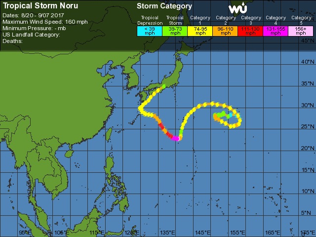
| Figure 5. The long, strange path of Tropical Storm Noru since its formation as a tropical depression on July 20. Noru became the planet’s first Category 5 storm of the year on July 30, with top sustained (1-minute) winds of 160 mph. |
Noru grinds across Japan
Even though its top sustained winds fell below typhoon strength on Monday, long-lived Tropical Storm Noru will make its presence known across southwest and central Japan over the next couple of days. Noru made landfall south of Osaka as a minimal-strength typhoon (the equivalent of a Category 1 hurricane) at around 1:00 am EDT Monday (3 pm local time), as reported by weather.com.
As it continues inland, Noru will drop heavy rains across large parts of Kyushu, Shikoku, and Honshu islands. Much of Honshu can expect 2” – 4”, with much heavier amounts of up to 12” at higher elevations. Three-day rainfall topped 680 mm (26.77”) at Naze, a station in the Satsunan Islands of far southern Japan.


