| Above: Tropical Depression Eight as seen by the GOES-16 satellite at 10:30 am EDT August 13, 2017. Image credit: NOAA/CIRA/RAMMB. NOAA’s GOES-16 satellite has not been declared operational and its data are preliminary and undergoing testing. |
Tropical Depression Eight (TD 8) formed on Saturday evening in the Atlantic waters between the Lesser Antilles Islands and Bermuda, and is likely to become the seventh named storm of the season--Tropical Storm Gert--by Monday. TD 8 is not expected to be a threat to any land areas, and no Hurricane Hunter flights were scheduled into TD 8 as of midday Sunday.
Satellite images late Sunday morning showed that the heavy thunderstorm activity associated with Tropical Depression Eight was limited primarily to the east side of the circulation, thanks to dry air interference. The system was embedded in an environment of very dry air with a relative humidity at mid-levels of the atmosphere near 45%. Otherwise, conditions were favorable for development, with low wind shear of 5 – 10 knots and warm sea surface temperatures of 29°C (84°F). TD 8 was fairly symmetric with respectable upper-level outflow developing, and could well be a strong tropical storm by Tuesday.
The seventh named storm of the Atlantic hurricane season occurs, on average, on September 16, so we are seeing a lot of early-season activity this year. The record earliest seventh Atlantic named storm was 2005’s version of Tropical Storm Gert, which got its name on July 24 of that year.
Forecast for TD 8
The 12Z Sunday SHIPS model predicted that wind shear over TD 8 would mostly be in the moderate range, 10 – 20 knots, through Tuesday, which should allow TD 8 to intensify into Tropical Storm Gert. By Wednesday, the storm will begin encountering very high levels of wind shear above 30 knots, which should kill the system by Thursday or Friday. The models are in excellent agreement on a track arcing to the north then northeast early this week, taking TD 8 midway between North Carolina and Bermuda, then out to sea well south of the Canadian Maritime Provinces.
 |
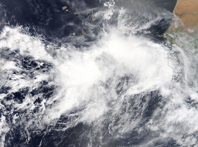
| Figure 1. MODIS true-color satellite image of a tropical wave that emerged from the coast of Africa on Sunday morning, August 13, 2017. Image credit: NASA. |
New African tropical wave 91L may develop
A gradually developing wave in the eastern Atlantic dubbed Invest 91L is well positioned to take a steady course toward the Greater Antilles, and perhaps continuing further west more than a week from now. Much like its predecessor (the wave that became TD 8), 91L is starting out as a complex, elongated system. A strong tropical wave that moved off Africa on Saturday has been catching up to another wave located to its southwest, south of the Cape Verde islands. The complex maintained a large amount of strong convection (showers and thunderstorms) on Sunday, despite the usual afternoon minimum in convection over the tropical oceans.
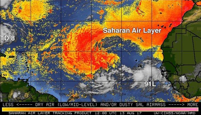
Given its dual structure, it may take a day or more for 91L to organize around a single focal point. Assuming it does, conditions are quite favorable for more development through at least midweek. The atmosphere surrounding 91L, and downstream of it, is consistently moist (mid-level relative humidity close to 70 percent). The Saharan Air Layer (SAL) is far enough northwest that it should not pose any immediate issues for 91L (see Figure 2 below). Wind shear along 91L’s path is predicted to be mostly light (less than 10 knots) through Tuesday, and sea surface temperatures of 27-28°C (81-82°F) are about 0.5°C to 1°C above average for this time of year. We can expect all of these factors to help 91L strengthen steadily once it develops a dominant center of circulation. In its tropical weather outlook issued at 8:00 am EDT Sunday, August 13, 2017, the National Hurricane Center gave 91L (right) a near-zero chance of development through Tuesday and a 20% chance through Friday. Given the favorable environment around 91L, those odds may be nudged higher before too long.
 |
| Figure 2. The Saharan Air Layer (SAL) analysis from 8 am EDT Sunday, August 13, 2017, showed that dry Saharan air lay well to the north of tropical wave 91L, and it should not be a major impediment to development early this week. Image credit: University of Wisconsin/CIMSS/NOAA Hurricane Research Division. |
Long-range outlook for 91L
91L is moving almost due west, and that general motion is expected to continue throughout this week, with a slight northward bend over time. A large, flat upper trough known as a tropical upper tropospheric trough, or TUTT, will be stretching west across the subtropical Atlantic ahead of 91L. This TUTT may exert some increased wind shear on 91L later in the week, but the trough is predicted to continue westward and weaken over time. The upper-level westerly flow associated with the TUTT might even provide an outflow jet for 91L late in the week.
The global models from 00Z Sunday provide some support for 91L posing a threat to the northern Caribbean or Greater Antilles next weekend, and possibly to Mexico or the United States beyond that point. The 00Z Sunday operational runs of the GFS, UKMET, and European models all develop 91L to various extents by next weekend, taking it near or just north of the Greater Antilles by that point. The GFS is the strongest of the three with 91L, and the Euro the weakest. About half of the Euro model ensemble members from 00Z Sunday, and all members of the GFS ensemble, develop 91L into a tropical cyclone by Thursday. Nearly all of the Euro and GFS ensemble members that develop 91L track it across or near the Greater Antilles, and several ensemble members continue the system westward into the Gulf of Mexico or into the western Atlantic near or north of the Bahamas.
At this early stage, it is far too soon to know how strong 91L might become, or how a trek across the Greater Antilles would affect its strength downstream, but the supportive environment and the track forecast imply we might be watching 91L for quite a few days to come.
Jeff Masters co-wrote this post.


