| Above: Tropical Depression 4 in the Central Atlantic as seen by the new GOES-16 satellite on Thursday afternoon, July 6, 2017. A large area of orange-brown African dust was chasing TD 4 as it sped to the west, as seen in this excellent video from NOAA/CIRA/RAMMB. |
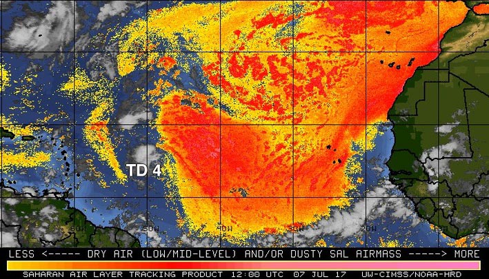
Tropical Depression Four continues to struggle against dry air and is likely to dissipate Friday night or Saturday morning before passing just north of the northernmost Lesser Antilles Islands. Satellite images on Friday morning showed that the circulation of TD 4 was weak, and the storm had a decreasing amount of thunderstorm activity. The cloud tops of these thunderstorms were warming, showing that they did not extend as high in the atmosphere due to weaker updrafts supporting them. This weakening trend was likely due to dry air from the Saharan Air Layer (SAL), which had wrapped into the circulation center from the east. Wind shear was favorable for development, a light 5 - 10 knots, and sea surface temperatures (SSTs) were adequate for development, near 27.5°C (82°F)--about 1°F above the seasonal norm.
|
Figure 1: The Saharan Air Layer (SAL) analysis from 8 am EDT Friday, July 7, 2017, showed a large area of dry Saharan air to the east of TD 4. This dry air was being entrained into the center of the storm. Image credit: University of Wisconsin CIMSS/NOAA Hurricane Research Division. |
Unfavorable conditions for development
Dry air will be TD 4’s main impediment to development, as diagnosed by the 12Z Friday run of the SHIPS model--relative humidity at mid-levels of the atmosphere were at 50% Friday morning, and are expected to fall to 45% by Saturday. This dry air, in combination with increasingly strong upper level winds out of the west that will start creating moderate wind shear of 15 – 20 knots by Saturday morning, should cause TD 4 to dissipate Friday night or Saturday morning. The models predict a continued west-northwest motion at about 20 mph for TD 4 or its remnants over the weekend, and the system may pass close enough to the northern Lesser Antilles Islands on Sunday to bring a few rain showers and gusty winds. Given the dry air surrounding TD 4 and the meager amount of heavy thunderstorms associated with the storm, I’m not expecting any dangerous flooding rains in the Lesser Antilles Islands.
We'll have to keep an eye on the remnants of TD 4 when they enter the Bahama Islands by the middle of next week, where increased low level moisture, warm SSTs and low to moderate wind shear may allow some re-organization of the system to occur.
The next African wave to watch emerges Saturday
The next tropical cyclone threat in the Atlantic may well be a tropical wave expected to come off the coast of Africa on Saturday night. Impressively, the 0Z Friday operational runs of both the GFS and European models showed this wave spinning up into a hurricane before reaching the Lesser Antilles Islands on Saturday, July 15. However, only two of the 70 ensemble members of these models showed a hurricane forming in their 0Z Friday runs, and only about 20% of the members of the European model ensemble predicted that the African wave would even develop into a tropical depression. The wave is predicted to take a mostly westward track at about 20 mph, and emerge far enough to the south (9° - 10° N) so that dry air from the Saharan Air Layer should not greatly interfere with development. However, the wave will be too close to the equator to allow the system to gain much spin by leveraging the Earth's spin, and the fast forward speed of the system may slow development.


