| Above: GOES-16 view of TD 16, at noon EDT Wednesday, October 4, 2017. Image credit: NOAA/RAMMB. GOES-16 imagery is considered preliminary and non-operational. |
Dangerous Tropical Depression 16 formed on Wednesday morning in the Southwestern Caribbean off the coast of Nicaragua, and is likely to develop into Tropical Storm Nate later in the day as it moves northwest at 7 mph. TD 16 is likely to be a significant rainfall threat to Central America over the next two days, and a dangerous rainfall, storm surge, and wind threat for portions of the U.S. Gulf Coast this weekend.
 |
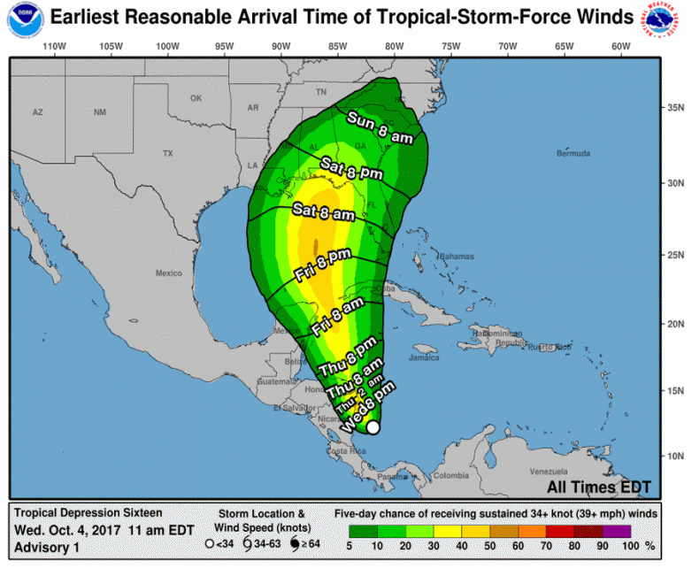
| Figure 1. The 11 am Wednesday NHC forecast for the probability of tropical-storm-force winds for the five days ending on Monday, October 9, 2017. The Panhandle of Florida was given about a 30 - 40% chance of tropical storm-force winds of 39+ mph, with those winds potentially arriving as early as Saturday night. Image credit: NOAA/NWS/NHC. |
Tropical storm warnings are up for much of the coast of Nicaragua and Honduras, but the main danger to Central America from TD 16 will be torrential rains: 15 – 20” in Nicaragua, 5 – 10” in Panama and Costa Rica, and 2 – 5” in Honduras. Much of the heavy rain in Nicaragua will occur on the Pacific side, as TD 16’s large circulation pulls moisture from the Pacific across Central America and into the Southwest Caribbean.
Satellite imagery on Wednesday afternoon showed that TD 16 was in the early stages of organization, with a modest area of heavy thunderstorms and a couple of prominent low-level spiral bands. One spiral band was already bringing heavy rain to Panama, as seen on Panama radar. Conditions were very favorable for development, with light wind shear around 5 knots, sea surface temperatures (SSTs) a very warm 30°C (86°F), and an unusually moist atmosphere with a mid-level relative humidity of 85%.
 |
| Figure 2. Ocean Heat Content (OHC) for October 4, 2017. Forecast positions for TD 16 from the 11 am EDT Wednesday NHC forecast are also shown. OHC values in excess of 80 kilojoules per square centimeter (yellow-green colors) are often associated with rapid intensification of hurricanes. TD 16 is expected to be passing over two areas of very high ocean heat content, with very warm waters that extend to great depth: in the Western Caribbean off the coast of Yucatan Peninsula, and again in the Gulf of Mexico, over the northern portion of the Loop Current, where a warm eddy appears to be attempting to break off. Image credit: University of Miami Rosenstiel School of Marine and Atmospheric Science. |
Intensity forecast for TD 16
TD 16 is in a favorable environment for intensification. The 12Z Wednesday run of the SHIPS model predicted that wind shear would mostly be low, 5 – 10 knots, through Saturday, with SSTs a very warm 30 – 30.5°C (86 - 87°F), and an unusually moist atmosphere with a mid-level relative humidity of 80 – 85%. After TD 16 creates its own distinct identity within the larger gyre of low pressure it is embedded in, the main impediment to intensification is likely to be interaction with land. The center of TD 16 is expected to pass over northeastern Honduras and Nicaragua during the day on Thursday, and then potentially encounter the northeastern tip of Mexico’s Yucatan Peninsula or the western tip of Cuba on Friday night.
The Wednesday morning runs of our top five intensity models showed modest intensification of TD 16, with only the HWRF model predicting that TD 16 would become a Category 1 hurricane before making landfall along the U.S. Gulf Coast on Sunday. However, TD 16 will be passing over two areas of very high ocean heat content (OHC), with very warm waters that extend to great depth: in the Western Caribbean off the coast of Yucatan Peninsula, and again in the Gulf of Mexico (Figure 2). If TD 16 has not been significantly disrupted by passage over land, the storm will have the opportunity to rapidly intensify by 30 mph or more in 24 hours when crossing over these warm ocean areas. The way this hurricane season has gone, it is safer to predict intensification at the upper end of what our intensity models are predicting. NHC’s forecast of a Category 1 hurricane at landfall in the Florida Panhandle this weekend is a reasonable one at this point, but TD 16 could just as easily be a Category 2 hurricane—or a large and very wet tropical storm that was never able to get its act together, due to land interaction. The 12Z Wednesday run of the HWRF model predicts that TD 16 will spend very little time over Nicaragua/Honduras on Thursday, with the storm becoming Hurricane Nate by late Thursday afternoon. If this track does indeed verify, I expect that TD 16 will be a Category 1 hurricane on Friday afternoon when it makes its closest pass to Cozumel, the northeastern tip of the Yucatan Peninsula, and the western tip of Cuba.
 |
| Figure 3. The 20 track forecasts for TD 16 from the 6Z Wednesday, October 4, 2017 GFS model ensemble forecast. A more westerly track into Louisiana is preferred. |
 |
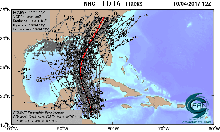
| Figure 4. The 0Z Wednesday October 4, 2017, track forecast by the operational European model for TD 16 (red line, adjusted by CFAN using a proprietary technique that accounts for storm movement since 0Z), along with the track of the average of the 50 members of the European model ensemble (heavy black line), and the track forecasts from all 50 members of the ensemble. A more easterly track into the Florida Panhandle or Big Bend area is preferred. Image credit: CFAN. |
Track forecast for TD 16
Southerly flow around the eastern flank of an upper level trough of low pressure over the western Gulf of Mexico is expected to steer TD 16 to the northwest, then north, over the next three days, and the NHC cone of uncertainty extends from coastal Alabama eastward to near Cedar Key, Florida on Sunday morning. There is a considerable spread in where the models say TD 16 might eventually make landfall, with the 0Z, 6Z, and 12Z Wednesday runs of the GFS model predicting a landfall in Louisiana, and the 0Z Wednesday runs of the European and UKMET models predicting a landfall in the Florida Panhandle. The NHC discussion on Wednesday morning stated that their analysis showed that the GFS model had the trough steering TD 16 to be too strong, resulting in a track too far to the west.


