| Above: Giant hail fell on Sayre, OK, from a supercell thunderstorm that went on to produce a deadly tornado in Elk City, about 110 miles west of Oklahoma City. Image credit: Stacey Valdez, via AP. |
Storm surveys were under way on Wednesday after tornadoes killed at least two people and injured dozens on Tuesday in Wisconsin and Oklahoma. Severe weather will continue to rake the central U.S. throughout this week, with an especially worrisome set-up for strong tornadoes lining up for Thursday (see below).
As of midday Wednesday, the NOAA/NWS Storm Prediction Center had received 28 preliminary tornado reports from Tuesday, along with 92 reports of severe wind gusts and 108 reports of severe hail. Baseball-sized hail was reported in northwest Wisconsin, southwest Kansas, and the Oklahoma and Texas panhandles, with a report of softball-sized hail from western Oklahoma. At one point Tuesday night, severe thunderstorm watches extended from the Texas-Mexico border to the Great Lakes.
 |
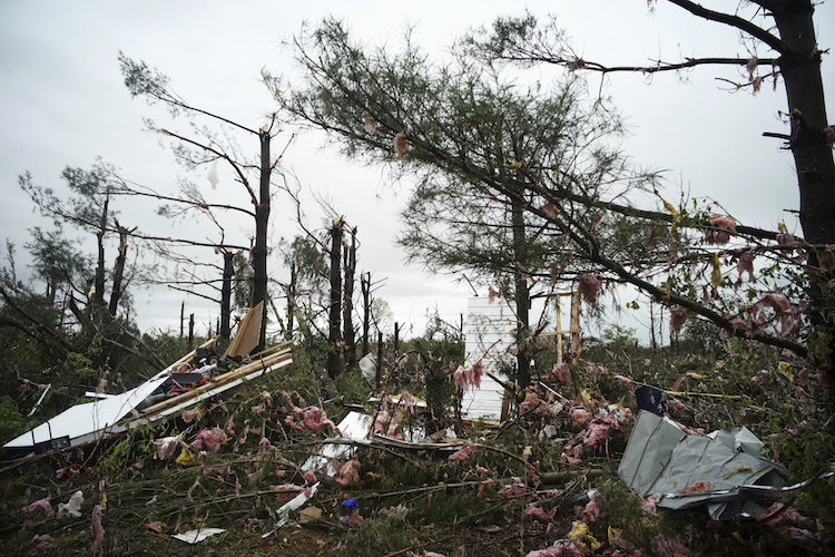
| Figure 1. A tornado flattened large parts of a trailer park and nearby trees in a mobile home park Tuesday, May 16, 2017, just north of Chetek, Wis., during powerful spring storms that battered an area from the South Plains of Texas to the Great Lakes. Image credit: Richard Tsong-Taatarii/Star Tribune via AP. |
One person was killed and at least 25 others injured when a tornado struck a mobile home park in Barron County of northwest Wisconsin around 5:30 pm CDT Tuesday. The twister ravaged the Prairie Lake Estates mobile home park, located about 3 miles north of the lakeside community of Chetek and about 60 miles east-northeast of Minneapolis. At least half of the 50 homes on the park were destroyed, according to reports in the Eau Claire Leader-Telegram.
The supercell thunderstorm that produced the Chetek tornado, and dropped giant hailstones along the way, was clearly tracked through radar and visual reports. The first tornado warning for southwest Barron County was issued at 4:39 pm CDT. Another warning was issued at 5:05 pm for southeastern Barron County, including the Chetek area.
Manufactured homes are notoriously unsafe in even weak tornadoes. Over the past few years, roughly 45% of all tornado deaths have occurred in mobile homes, although only about of 6% of all Americans live in them. According to SPC data, 18 of the 32 tornado deaths for 2017 thus far (prior to Tuesday) were associated with mobile homes.
 |
| Figure 2. Looking west-southwest at an intense supercell thunderstorm near the TX/OK border east of Wellington, TX, about an hour before it produced a deadly tornado in Elk City, OK, on Tuesday evening, May 16, 2017. Image credit: © 2017 Matt Crowther, used with permission. |
A subdivision on the south side of Elk City, Oklahoma, experienced significant tornado damage on Tuesday. More than 50 homes were damaged or destroyed when the tornado struck around 7:10 pm, according to the Daily Oklahoman. A resident fleeing the twister was killed when his pickup truck was thrown several hundred feet, weather.com reported.
As with the Wisconsin twister, the Elk City tornado emerged from an obvious supercell, and it had been tornado-warned for more than an hour, although observers reported it was rain-wrapped at times. An NWS tornado warning for the Elk City area was issued at 6:54 pm CDT and reiterated at 7:08 pm CDT.
 |
| Figure 3. An Oklahoma Mesonet station 5 miles south of Elk City experienced westerly wind gusts to 74 mph as a tornado passed several miles to its north. Image credit: Oklahoma Mesonet. |
 |
| Figure 4. Velocity (left) and reflectivity (right) associated with the Elk City tornado, as detected by a mobile Doppler radar operated by the Center for Severe Weather Research. The tornado is located at the center of the highly contrasting blue and yellow colors on the left image, and in the “donut hole” on the right image, on the south side of a supercell thunderstorm (top right). Image credit: Courtesy Karen Kosiba/CSWR, via Tim Marshall. |
The outlook for Wednesday through Friday
A strong upper low pinwheeling across the western U.S. will continue to spawn severe weather through at least Friday. The compact, intense upper-level wave that triggered Tuesday’s tornadic storms in the Southern Plains was swinging toward the Midwest on Wednesday, where it will generate more severe weather. Most of Iowa was under an enhanced risk of severe weather in the SPC outlook issued at 11:30 am CDT Wednesday. Moderately unstable air was already in place to fuel severe storms. Winds were increasing strongly with height, but there was little directional change with height; this may help cut back on the storm rotation that would lead to significant tornadoes. The widespread storm coverage may also work against the presence of individual tornadic supercells.
 |
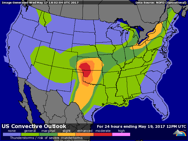
| Figure 5. NOAA/SPC outlook for severe weather issued midday Wednesday and valid on Thursday, May 18, 2017. |
Thursday’s outlook is more concerning for tornadoes. Moisture will be surging back into the Southern Plains, and another strong impulse will be swinging around the upper low across the region. NOAA/SPC has already tagged parts of northwest Oklahoma and southern Kansas with a moderate risk for Thursday. The atmospheric profiles expected on Thursday afternoon over parts of OK/KS are almost textbook-ideal for rotating, potentially tornado-producing supercells. Winds are forecast to be strengthening and veering dramatically through the lowest few miles of the atmosphere, and extreme instability may be present—in some areas, more than 3000 J/kg of convective available potential energy (CAPE).
As was the case on Tuesday, the greatest tornado threat will likely emerge in sparsely populated areas well west of the Wichita-Oklahoma City-Dallas corridor. The most intense storms may occur along a warm front across southern KS and near the “triple point” intersection of the warm front and a dryline near the western border of OK.
Severe weather may continue across the Southern Plains on Friday, perhaps extending toward the mid-Mississippi Valley. The risk of very heavy rain and potential flash flooding will be on the rise, with a stalled frontal system and moisture continuing to stream north from the tropics and subtropics. Meanwhile, it will be anything but tropical in northern Colorado: the mountains and higher foothills west of Denver may get 1 to 3 feet of snow, and accumulations are possible in the Denver/Boulder area by Friday morning. See Jon Erdman’s weather.com roundup for more on the snow prospects, which are unusual but not unprecedented for late May in the Denver area.


