| Above: In this forecast for winds at the 250-millibar level (about 34,000 feet high) for 8 pm EDT Wednesday, March 22, 2018, the polar jet stream was predicted to send a powerful atmospheric river into Southern California while arcing around a potential nor’easter (not shown) just off the northeast U.S. coast. The forecast was produced by the GFS model at 0Z Monday. Image credit: tropicaltidbits.com. |
An energetic polar jet stream ripping across the United States will lead to yet another nor’easter this week (see below), as well as a chance of tornadic supercells in and near northern Alabama and the potential for major flash flooding in coastal Southern California, especially in the wildfire-scarred hills of Ventura and Santa Barbara counties.
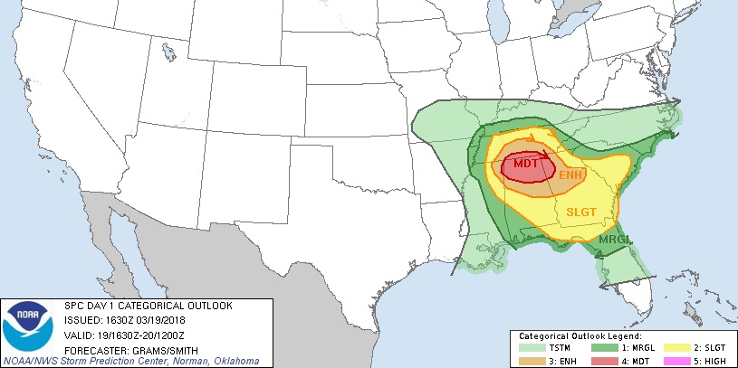
Monday’s severe weather is not expected to cover a vast area, but it could be intense. Update: At 11:30 AM CDT Monday, the NOAA/NWS Storm Prediction Center issued the year's first moderate-risk outlook for severe weather (the second highest of five threat categories). Areas of enhanced and slight risk encompass the moderate-risk area and extend southeastward (see Figure 1). SPC noted a chance of significant tornadoes—EF2 or stronger on the Enhanced Fujita Scale—and very large hail (larger than 2”).
 |
| Figure 1. Severe weather outlook for Monday, March 19, 2018, issued at 1630Z (11:30 am CDT) Monday. Image credit: NOAA/NWS/SPC. |
Update (11:45 am CDT): The most likely location for tornadic supercells will be near and just south of a warm front expected to stretch from a surface low in western Tennessee into Georgia by Monday afternoon. Tornadoes are also possible just north of the warm front in Tennessee, but storms may be too numerous and instability too meager to allow individual supercells to form in that area. Northern Alabama will likely see the most serious combination of strong vertical wind shear, relatively high instability, and a "cap" of warm air about 1-2 miles high that's expected to suppress storm formation until afternoon heating is maximized. Extensive clouds may limit surface warming somewhat, but in a high-wind-shear environment such as today's, instability does not need to be extreme for tornadic supercells to form. Tornado-producing supercells may progress into northern and central Georgia toward Monday evening before the storms congeal into larger clusters.
Residents should take this threat seriously, as climatology favors the South for late-winter and early-spring twisters. Note also that today's storms could be racing eastward at 40-50 mph.
The most recent @NWSSPC Mesoscale Discussion concerning the upgrade to a MDT risk of severe weather in northern Alabama due to tornadoes is aligned practically to perfection with sig TOR climatology for late March. #alwx pic.twitter.com/kxDO4rm9Kg
— Eric Webb (@webberweather) March 19, 2018
Atmospheric river expected to smash into Southern California later this week
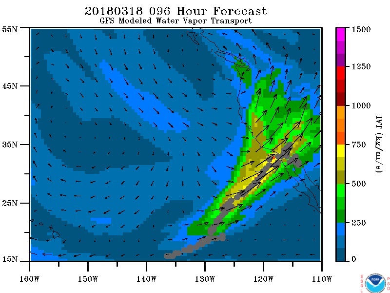
A channel of rich moisture surging from the tropical Pacific in “Pineapple Express” fashion will be aimed squarely at the coastal terrain of Southern California from late Tuesday through Thursday, setting the stage for a prolonged and intense rain event. The 00Z Monday GFS model predicts that the atmosphere will be hauling 1.2” to 1.4” of precipitable water (the amount of moisture in a column above ground level) into coastal sections from San Diego to Santa Barbara. If those amounts come to fruition, they will challenge the region’s March records for atmospheric moisture going back to the 1940s, as noted by Daniel Swain at California Weather Blog (see below).
 |
| Figure 2. This depiction of integrated water vapor transport (IVT)—a measure of the amount of water vapor in a channel crossing an imaginary perpendicular threshold every second—shows a narrow plume of rich moisture impinging on the southern California coast at 18Z (11 am PDT) Thursday, March 22, 2018, as predicted by the 18Z Sunday run of the GFS model. Image credit: NOAA/ESRL. |
Rains of 2-4” will be widespread from Tuesday through Thursday across coastal Southern California and nearby valleys, including the Los Angeles area, which has suffered through one of its driest winters on record thus far.
Amounts of 4-6” or more are possible at higher terrain, especially hillsides that face the incoming atmospheric river. This includes the scorched terrain of Ventura and Santa Barbara counties, where the largest wildfire ever recorded in California raged last December. On January 9, flash flooding driven by heavy rains across the fire-scarred hillsides killed 21 people, most of them in the hard-hit coastal city of Montecito. Rainfall in the burn area could be more intense and/or prolonged with this system than in January, so flash flood watches and evacuations are a strong possibility. A pre-evacuation advisory for burn areas was issued on Saturday by the Santa Barbara County Office of Emergency Management.
Another week, another nor’easter…
Winter-weary residents of the northeast U.S. will have to contend with at least one more round of cold rain and/or snow later this week. Details had yet to fully congeal in the forecast models as of Sunday night, but the surface low moving through the mid-South on Monday is expected to gather strength off the mid-Atlantic coast from Tuesday into Wednesday. Impulses traveling along the strong polar jet will make for a prolonged and complex set-up.
Upper levels will be quite cold for late March, which means snow could fall a bit further south than in other recent storms—from southern New England and the New York City area well into Virginia, with a band of heavier snow possible for Philadelphia and Washington, D.C. Working against big accumulations will be marginal surface temperatures, the strengthening sun of late March, and relatively warm ground temperatures. Still, a few inches of snow will be possible in some areas if the ingredients and timing align. Once again, strong winds and flooding may rear their heads from the mid-Atlantic to New England. See the weather.com article on this storm for frequent updates.
Jeff Masters will have a post later Monday on February’s global climate report.
Upcoming #atmosphericriver will not only contain very moist subtropical air, but will coincide with fairly strong low-level jet: a recipe for intense "integrated water vapor transport (IVT)." In fact, ensemble mean now has IVT at record values for March! #CAwx #ThomasFire pic.twitter.com/mUxHiJLdHB
— Daniel Swain (@Weather_West) March 18, 2018


