| Above: Visible-wavelength satellite image of Hurricane Irma as of 15Z (11 am EDT) Monday, September 4, 2017. Image credit: RAMMB / CIRA @ CSU. |
Dangerous Hurricane Irma was intensifying as it approached the northern Lesser Antilles Islands on Monday morning, and island residents in the path of Irma need to rush preparations to completion as the storm heads west-southwest at 14 mph. A NOAA hurricane hunter aircraft in the storm found that Irma’s central pressure was steadily dropping Monday morning, reaching 944 mb at 11 am EDT. Irma's top sustained winds are estimated at 120 mph, and winds may not yet have fully responded to this pressure drop. Update: Based on Hurricane Hunter measurements, NHC raised Irma's top sustained winds at 5:00 pm EDT to 130 mph, making it a Category 4 storm. Irma is expected to be a major Category 4 hurricane when it passes very close to the northern Lesser Antilles Islands on Tuesday, near Puerto Rico and the Virgin Islands on Wednesday, and the Turks and Caicos Islands and Hispaniola on Thursday. As of 5 pm EDT Monday, Hurricane Warnings are in effect for the northern Leeward Islands, and Hurricane Watches are up for the U.S. and British Virgin Islands and Puerto Rico.
Tropical storm-force winds are expected to begin affecting the east coast of Florida and the Florida Keys on Friday night (Figure 1 below). An evacuation decision for the Florida Keys may have to come as early as Tuesday, since the Keys require 3+ days to evacuate. As of 5 pm EDT, far southeast Florida, including Miami, was in the 5-day cone of uncertainty for Irma.
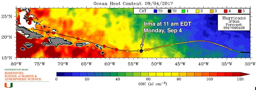
Satellite images on Monday morning showed a very symmetric well-organized storm with solid spiral banding and a large eye. Irma had a respectable and improving upper-level outflow on all sides. Conditions were favorable for strengthening, with wind shear a low 5 – 10 knots. Sea surface temperatures (SSTs) along Irma's path have risen sharply over the past day, to 29°C (84°F), accompanied by a substantial increase in the total heat content of the ocean (Figure 2), giving the storm plenty of heat energy to fuel intensification. The surrounding atmosphere has been steadily moistening, as seen on precipitable water imagery, with a mid-level relative humidity near 55%, according to the 12Z Monday analysis from the SHIPS model.
 |
| Figure 1. Most likely arrival time of tropical-storm-force winds from Irma, as of the 11 am EDT Monday, September 4, 2017 advisory from NHC. |
Intensity forecast for Irma
For the next five days, wind shear is predicted by SHIPS to remain very favorable for development—a low to moderate 5 - 15 knots. SSTs will be very warm, 29 - 30°C (84 - 86°F), accompanied by a high ocean heat content capable of fueling rapid intensification. Mid-level relative humidity is predicted to steadily rise, reaching 70% by the end of the week. We can expect one or more eyewall replacement cycles (ERCs) this week, which will act to temporarily weaken the hurricane by about 10 mph. On Monday morning, the hurricane hunters found that an ERC was likely in progress, and the current intensification cycle will likely pause late today, as a result.
Our most reliable intensity models--the HWRF, COAMPS-TC, LGEM, and DSHIPS--predicted in their Monday morning runs that Irma would peak as a Category 4 or 5 hurricane with 130 - 160 mph winds, and the official NHC forecast of a Category 4 hurricane when it passes by the islands this week looks reasonable. The only major impediment to Irma’s strength would appear to be interaction with land; a close pass or direct hit on Hispaniola or Cuba could potentially damage or destroy the hurricane’s inner core and knock it down to Category 2 or 3 strength.
 |
Figure 2. Total ocean heat content (OHC) along the track of Hurricane Irma, at 2 am EDT Monday, September 4, 2017. Irma is expected to encounter OHC levels of 80 – 100 kilojoules per square centimeter as it passes the Lesser Antilles islands. OHC levels this high are known to be very favorable for rapid intensification, and are similar to what fueled Hurricane Harvey’s rapid intensification over the Gulf of Mexico during its approach to the Texas coast (Figure 3). Image credit: University of Miami Rosenstiel School of Marine and Atmospheric Science. |
 |
| Figure 3. Total ocean heat content (OHC) along the track of Hurricane Harvey on August 25, 2017. Harvey encountered OHC levels of 80 – 100 kilojoules per square centimeter as it moved to the northwest towards Texas. This large amount of heat helped fuel the storm’s rapid intensification into a Category 4 hurricane. Image credit: University of Miami Rosenstiel School of Marine and Atmospheric Science. |
How strong could Irma get?
Several computer models have been confronting meteorologists with some eye-opening intensity forecasts for Hurricane Irma, especially for the period around next weekend, when Irma is currently predicted to be arcing northwest from the Eastern Bahamas. We cannot rule out the chance that Irma will reach Category 5 strength, but we can safely discount some of the most extreme model-generated intensities. The GFS global model and the new HMON regional hurricane model have consistently been deepening Irma to pressures below 900 millibars (mb). However, neither of these models fully incorporates the interaction between ocean and atmosphere that serves as a check on a hurricane’s peak strength. A better guide to how strong Irma might get is the HWRF regional hurricane model, which extends out to 126 hours (just over five days). The HWRF has proven to be our most reliable model-based intensity guidance in recent years. The 0Z and 6Z Monday operational runs of HWRF deepened Irma to the 920 - 930 mb range, suggesting Irma will be a very formidable hurricane, but not a mind-blowing all-time record-setter.
For historical context, the lowest hurricane-related pressure ever measured at the surface north of the Caribbean and east of Florida is 921 mb in the Bahamas Hurricane of 1932. Hurricane Hunter dropsondes found a surface pressure of 919 mb within Hurricane Gloria (1985). Such pressures can support a Category 4 or 5 hurricane, but the peak winds depend on the size of the hurricane. As hurricanes move poleward, they typically get bigger. In a larger hurricane, the pressure force from a given central pressure will extend over a larger area, meaning that the top sustained winds will probably be lower but that a larger area could experience high winds and storm surge. This was the case with Hurricane/Superstorm Sandy, which brought record-low surface pressures and record-high surge across a large area despite winds of marginal hurricane force at best when Sandy made landfall.
Potential impact on the Lesser Antilles, Virgin Islands, and Puerto Rico
Irma will assume a more westerly and west-northwesterly track over the next day, bringing the core of Irma just north of the Lesser Antilles, Virgin Islands, and Puerto Rico on Tuesday and Wednesday. Irma is a medium-sized hurricane, with tropical storm-force winds that extend out 140 miles from the center, and hurricane-force winds that extend out 35 miles from the center. Most of the islands along Irma’s path will be on the weaker left side, where maximum wind speeds 10 – 20 mph less than the peak winds of the storm can be expected.
The 11 am EDT Monday Wind Probability Forecast from NHC highlighted a number of islands that might be at risk of tropical storm-force or hurricane-force winds on Tuesday and Wednesday. The highest odds were for Barbuda and Saint Maarten, with a 93% chance of tropical-storm force winds and a 52 -54% chance of hurricane-force winds. For the Virgin Islands and Puerto Rico, a 56 - 82% chance of tropical-storm force winds was given, and an 18 - 38% chance of hurricane-force winds.
The 6Z Monday run of the HWRF model predicted that northern portions of the Dominican Republic and Haiti, as well as eastern portions of Cuba, may receive rains of 8 – 16” from Irma. These rains will be capable of causing life-threatening flooding and mudslides. The model also predicted heavy rains of 8 – 16” in the Turks and Caicos Islands and the southeastern Bahamas.
Long-range outlook for Irma
Computer model guidance on Irma’s future track made an important westward shift on Sunday night. Virtually all models—including our most reliable ones for hurricane track forecasts, the GFS, European, and UKMET—took Irma further west than prior model runs before an expected sharp turn to the north. This shift increases the chance that Irma will directly affect Hispaniola and especially Cuba, as discussed above. The shift also raises the odds for a U.S. landfall considerably, because Irma’s expected right turn toward the north would probably occur too late for Irma to miss the U.S. East Coast entirely. A strong upper-level trough will be moving well offshore by early next week, reducing the odds that Irma would be hauled out to sea.
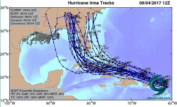
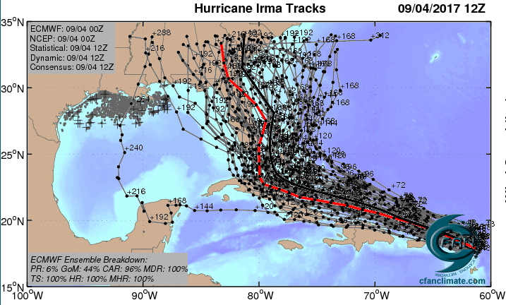
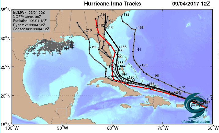
Figures 4, 5, and 6 show the dramatic shift southwestward and its implications for landfall in three different configurations of ensemble models (GFS, Euro, and Euro high-probability). The 00Z Monday UKMET model, not shown, moves Irma along or near the north coasts of Puerto Rico, Hispaniola, and Cuba.
 |
| Figure 4. The 20 track forecasts for Irma from the 0Z Monday, September 4, 2017 GFS model ensemble forecast. Image credit: CFAN. |
 |
| Figure 5. The 0Z September 4, 2017, track forecast by the operational European model for Irma (red line, adjusted by CFAN using a proprietary technique that accounts for storm movement since 0Z), along with the track of the average of the 50 members of the European model ensemble (heavy black line), and the 50 track forecasts from the 0Z Monday European model ensemble forecast (grey lines). Image credit: CFAN. |
 |
| Figure 6. The 0Z September 4, 2017, track forecast by the operational European model for Irma (red line, adjusted by CFAN using a proprietary technique that accounts for storm movement since 0Z), along with the track of the average of the 50 members of the European model ensemble (heavy black line), and the track forecasts from the “high probability cluster” (grey lines)—the four European model ensemble members that have performed best with Irma thus far. Image credit: CFAN. |
It is unclear exactly why the modeled track shifted so dramatically on Sunday night, but the Monday morning (12Z) GFS run is very consistent with this shift, lending support to it. One piece of the puzzle is that the first Hurricane Hunter observations on Irma, gathered Sunday afternoon, were fed into the 00Z Monday runs. A raft of additional new data will be gathered on Monday and fed into upcoming model runs. This includes observations around Irma’s environment from the NOAA Gulfstream-IV, as well as extra radiosonde launches (weather balloons) that will sample the upper atmosphere at midday Monday (18Z) from 21 locations across the central U.S., where the upper-level trough expected to move offshore late this week will be taking shape. The model runs from 00Z Tuesday will incorporate the new data, so this will give us a much better sense of the steering currents guiding Irma and how those may evolve over the next week.
Irma is still four days from any potential direct U.S. impacts, so there is plenty of time for residents along the East Coast and eastern Gulf Coast to make any standard preparations for hurricane season that haven’t yet been squared away. The Sunday night model runs suggest that the entire Florida peninsula will need to pay very close attention to Irma, but it remains possible that Irma will move further north along the East Coast, or it could enter the eastern Gulf of Mexico. There is strong model support for a north-northwest track once Irma makes its major right turn late in the week. The crucial variables will be how long it takes that turn to occur, how sharp the turn is, and whether Irma’s strength has been dented by interactions with Hispaniola and/or Cuba, as noted above.
Bottom line: It is becoming more likely that Irma will move close enough to the northern Leeward Islands, Puerto Rico, Hispaniola, and/or Cuba for significant impacts. There is an increasing chance that Irma will strike the U.S. late in the weekend or early next week, quite possibly as a major hurricane. It is still too soon to predict the location or timing of any U.S. landfall with confidence.
 | |
| Figure 7. Infrared satellite image of 94L in central Atlantic at 1630Z (12:30 pm EDT) Monday, September 4, 2017. Image credit: NASA/MSFC Earth Science Branch. |
New tropical depression possible in the central Atlantic
A tropical wave located at 8 am EDT Monday morning near 10°N, 35°W, about 500 miles southwest of the Cabo Verde Islands, was moving west-northwest at 10 - 15 mph. This system was designated 94L by NHC on Monday morning. Satellite images on Monday morning showed the wave had a modest amount of spin, and heavy thunderstorm activity was gradually increasing. Conditions were favorable for development, with moderate wind shear of 15 - 20 knots, SSTs near 28.5°C (83°F), and a moist surrounding atmosphere.
The 0Z Monday operational runs of our three reliable models for predicting tropical cyclone genesis—the GFS, European and UKMET models—all predicted development of this wave by the end of the week, over the central tropical Atlantic. Residents of the Lesser Antilles Islands should keep an eye on this system, though less than 10% of the 70 members of the 0Z Monday GFS and European model ensemble forecasts showed 94L affecting the Lesser Antilles in the long term. In its tropical weather outlook issued at 8 am EDT Monday, the National Hurricane Center gave this system 2-day and 5-day odds of development of 30% and 70%, respectively. The next name on the Atlantic list of storms is Jose.
Gulf of Mexico disturbance has marginal chance to develop
A trough of low pressure in the southwestern Gulf of Mexico’s Bay of Campeche is producing disorganized heavy thunderstorms, as seen on satellite imagery. SSTs are very warm, but wind shear is moderate to high, 10 – 25 knots. One of our reliable models for predicting tropical cyclone genesis, the UKMET, developed the system, predicting that it would affect the coast of Mexico between Veracruz and Tampico with heavy rains late this week. The European model showed some weak development of the system, as did about 60% of its ensemble members; all of these forecasts kept the system bottled up in the southwestern Gulf of Mexico by the coast of Mexico. In its tropical weather outlook issued at 8 am EDT Monday, the National Hurricane Center gave this system 2-day and 5-day odds of development of 20% and 40%, respectively.
Dr. Jeff Masters co-wrote this post.
Ride along with WP-3D Orion #NOAA42 for the first flight through #HurricaneIrma. Flights continue today. Credit LT Rob Mitchell/NOAA pic.twitter.com/7sjigdNiv7
— NOAAHurricaneHunters (@NOAA_HurrHunter) September 4, 2017


