| Above: GOES-West infrared satellite image of TD 1-E, taken at 8 am EDT May 11, 2018. Image credit: NASA/GSFC. |
The Eastern Pacific hurricane season got off to an unusually early start on Thursday afternoon, when the first tropical depression of 2018, TD 1-E, formed in the waters more than 1200 miles west-southwest of the southern tip of Mexico’s Baja Peninsula. On Friday morning, TD 1-E was moving west at 10 mph, away from land, and was struggling with high wind shear of 35 – 45 knots. Satellite imagery on Friday morning showed that the high wind shear was keeping the low-level center of TD 1-E exposed to view, with only one area of heavy thunderstorms visible on the east side of its circulation. Wind shear is predicted to increase even further through Saturday, which is expected to tear the storm apart before it can become Tropical Storm Aletta.
The Eastern Pacific hurricane season officially starts on May 15, but this is the second year in a row that we have had an unusually early start to the season. TD 1-E’s formation date of May 10 is the second earliest appearance on record for a tropical depression in the Eastern Pacific. The only earlier tropical depression came just last year, when the depression that would go on to become Tropical Storm Adrian formed on May 9. The previous earliest appearance of a tropical depression in the Eastern Pacific (since reliable satellite records began in 1970) was on May 12, 1990, when Tropical Storm Alma got its start. Three other systems got their start on May 13, according to NOAA’s Historical Hurricane Tracks website. With a record-early start to the season last year, and another near-record early start this year, the question naturally arises—is the Eastern Pacific hurricane season getting longer? I discussed this in Wednesday’s Cat6 post.
 |
Figure 1. According to NOAA’s Historical Hurricane Tracks website, there were 39 tropical cyclones in the Eastern Pacific in May from 1950 - 2016, but only two of them made landfall at hurricane strength in May: Category 1 Hurricane Agatha of 1971, and Category 1 Hurricane Barbara of 2013. Last year’s Hurricane Adrian is not shown here. |
An upper level low over the Gulf of Mexico is worth watching early in the week
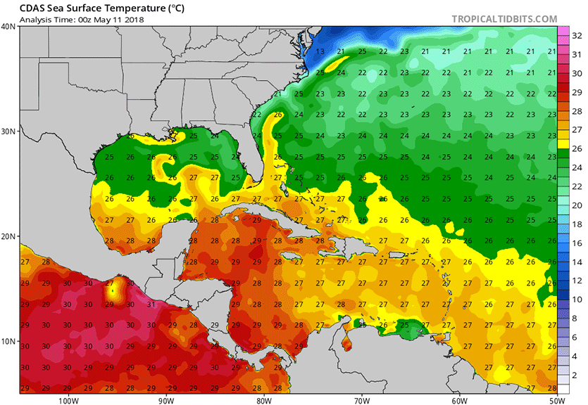
The Atlantic hurricane season officially starts on June 1, but we could see a tropical or subtropical depression form in the Gulf of Mexico by Wednesday off the coast of the Florida Panhandle. An upper-level trough of low pressure currently over the western Gulf of Mexico will move east and become a closed-off upper-level low pressure system that will stall out over the eastern Gulf over the weekend, bringing heavy rains to much of Florida. As this low meanders over the warm waters of the Gulf of Mexico on Sunday through Wednesday, the low has the potential to gradually acquire tropical characteristics and become warm-cored, potentially transforming into a tropical or subtropical depression. Sea surface temperatures (SSTs) off the coast of the Florida Panhandle are near 25°C (77°F)—a little cooler than is typically needed to see a tropical depression form, but plenty warm enough to support formation of a subtropical depression.
The Friday morning operational runs of our top three models for predicting tropical cyclone genesis—the European, GFS and UKMET models—did not predict that a tropical or subtropical cyclone would form in the Gulf of Mexico early next week. However, there was some support for this idea from the 0Z Friday ensemble runs of the GFS and European models, according to a custom forecast tool supplied to WU by cfanclimate.com. About 20% of the 50 members of the European model predicted that a tropical or subtropical depression could form by Wednesday in the Gulf, as did more than 50% of the 20 members of the GFS model. The National Hurricane Center was not giving this system any odds of development on Friday morning in their Tropical Weather Outlook, but I give this system 5-day odds of development of 10%.
 |
Figure 2. Sea surface temperatures (SSTs) off the coast of the Florida Panhandle are near 25°C (77°F)—a little cooler than is typically needed to see a tropical depression form, but plenty warm enough to support formation of a subtropical depression. SSTs in the Western Caribbean are near 28°C (82°F)—plenty warm enough to support a hurricane. Image credit: Levi Cowan, tropicaltidbits.com. |
The GFS model has also been predicting during much of the past week that an area of disturbed weather over Central America could act as the seed to get a tropical storm spinning in the Western Caribbean 7 – 12 days from now. Water temperatures there are near 28°C (82°F)—plenty warm enough to support a hurricane. The subtropical jet stream—which is typically located over the Caribbean in May, creating high wind shear that interferes with hurricane development—is predicted to lift northwards by late in the week, creating conditions favorable for tropical cyclone genesis. However, the long range runs of the European model have not been supporting this idea, and this is too far in the future to make reliable genesis forecasts. Thus, the GFS forecasts of a tropical storm in the Caribbean in 7 – 12 days should be viewed at this point as interesting, but improbable.


