| Above: Infrared satellite image of TC 2A, taken at 2 am EDT May 22, 2018. Image credit: NOAA. |
Tropical Cyclone 2A (TC 2A) formed on Tuesday morning in the Arabian Sea, and is expected to intensify rapidly before making landfall as a hurricane-strength storm near the Oman-Yemen border on Thursday night. At 2 am EDT Tuesday, TC 2A was a minimal strength tropical storm with 40 mph winds, and was still getting organized, as seen on satellite imagery. The storm had a large and impressive amount of heavy thunderstorms, but these did not wrap all the way around the center of circulation.
Conditions were very favorable for intensification, with sea surface temperatures (SSTs) ranging from 31 - 32°C (88 - 90°F), giving the storm an exceptional amount of heat energy to work with. Warm waters extended to great depth along the path of the storm, giving TC 2A a Tropical Cyclone Heat Potential in excess of 100 kilojoules per square centimeter—the kind of heat content often seen leading to rapid intensification. Wind shear over the system was a moderate 10 – 20 knots on Tuesday--also favorable for intensification. The Madden-Julian Oscillation (MJO), a pattern of increased thunderstorm activity near the Equator that moves around the globe in 30 - 60 days, and which can increase the odds of tropical cyclone formation when it is strong and located in the proper location, is currently strong and located in the Arabian Sea, a position that favors intensification of TC 2A. The atmosphere surrounding TC 2A is quite moist, but the storm will likely begin to pull in dry air from the Arabian Peninsula on Thursday as it approaches the coast, potentially disrupting the inner core of the storm.
 |
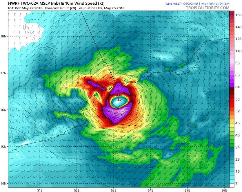
| Figure 1. Predicted wind speed (knots) for TC 2A at 3Z Friday, May 25, 2018 as predicted by the 6Z Tuesday, May 22, 2018, run of the HWRF model. This forecast has TC 2A approaching landfall near the Oman-Yemen border as a Category 2 hurricane with 100 mph winds and a central pressure of 960 mb, then weakening rapidly to a Category 1 hurricane or strong tropical storm at landfall, due to land interaction and dry air ingestion. Purple colors correspond to Category 1 hurricane strength (64 knots and greater). Image credit: Levi Cowan, tropicaltidbits.com. |
With conditions expected to be very favorable for intensification until Thursday, the only impediment to TC 2A becoming a hurricane would seem to be its initial disorganization, which may take the storm a day or so to overcome. Once TC 2A gets within six hours of landfall near the Oman-Yemen border on Thursday night, ingestion of dry air and land interaction may significantly disrupt the storm. The official forecast from Tuesday morning from the Joint Typhoon Warning Center (JTWC) has TC 2A making landfall as a Category 1 storm with 85 mph winds. TC 2A could easily be a strong Category 2 storm just before landfall, then weaken to Category 1 strength at landfall, as predicted by the 6Z Tuesday run of the HWRF model.
There is a fair amount of spread in the location and timing of TC 2A’s landfall among the models. While both JTWC and the India Meteorological Department (IMD) were calling for a landfall in western Oman near Salalah in their Tuesday morning forecasts, the 0Z and 06Z runs of the GFS and HWRF models were calling for a landfall almost 100 miles to the west of that, close to the Oman-Yemen border.
A dangerous flash flood threat
TC 2A is expected to hit near the border between Yemen and Salalah, Oman. Salalah (population 340,000) is a major port city and tourist destination, and receives just five inches of rain per year on average. The region could easily see double that amount of rain from TC 2A, leading to significant flash flooding. The 0Z and 06Z Tuesday runs of the HWRF model predicted a swath of 4 – 8” of rain would fall along a 150 mile-long section of the coast near the Oman-Yemen border, with a small area of rains in excess of 8” falling inland over mountainous terrain. Wind damage and storm surge are also significant threats, but it is TC 2A’s flooding rains that pose the main risk.
 |
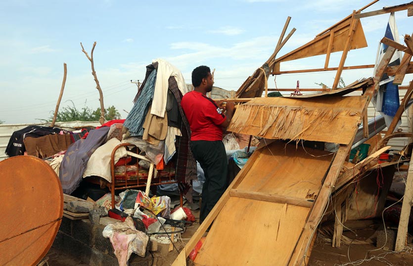
| Figure 2. A Yemeni man stands in the remains of a house in a neighborhood affected by Tropical Cyclone Sagar, in the port city of Hodeidah, on May 19, 2018. Image credit: ABDO HYDER/AFP/Getty Images. |
Recovery efforts continue from Tropical Cyclone Sagar
TC 2A is the second tropical cyclone to visit the Arabian Sea in the past week. Last week, the Arabian Sea experienced Tropical Cyclone Sagar, which made landfall on Saturday as the strongest tropical storm ever recorded in Somalia. Packing heavy rain and top sustained winds of 60 mph, Sagar made landfall further west than any tropical cyclone in 52 years of record-keeping for the North Indian Basin. Sagar struck at around noon local time Saturday about 100 miles southeast of the city of Djibouti, along the flat, arid coastal plain of far western Somalia. Sagar’s heavy rains caused destructive flooding that led to at least 15 deaths in Somalia. Damage also occurred in Yemen, Djibouti, Eritrea and Ethiopia.
Bob Henson contributed to this post.
We’ll have an update on Atlantic Invest 90L before 2 pm EDT.


