| Above: Visible GOES-16 image of Jose at 1605Z (12:05 pm EDT) Thursday, September 14, 2017. GOES-16 images are preliminary and non-operational. Image credit: RAMMB / CIRA@CSU. |
Tropical Storm Jose is predicted to restrengthen into a hurricane and arc just off the east coast of U.S. and Canada early next week. Chances are slim that the storm will make landfall, but it’s a good bet that coastal communities from the mid-Atlantic to the Canadian Maritimes will feel Jose’s presence. Meanwhile, there are four other potential landfalls across the North Pacific from Vietnam to Mexico over the next 3-5 days.
Jose was downgraded to a 70-mph tropical storm at 11 am EDT Thursday after more than a week at hurricane strength, peaking as a strong Category 4. Jose was located about 520 miles south-southwest of Bermuda, heading west-northwest at 7 mph. Relentless northerly shear of 20-25 knots has taken its toll on Jose, despite very warm sea-surface temperatures along its path (29-30°C or 84-86°F). The northerly winds have also lowered the mid-level relative humidity in Jose’s environment to around 50%, which is quite low for sustaining a hurricane. Even so, Jose has managed to maintain a surprisingly intense core of showers and thunderstorms (convection), as evident in Figure 1 below. Wind shear is predicted to drop to around 15 knots on Thursday night into Friday, and this may be just enough to allow Jose to regain hurricane strength, as predicted by NHC. Chances of any dramatic or rapid intensification are quite low, but Jose is expected to maintain Category 1 hurricane strength into early next week. Wind shear will again be on the increase next week, and it seems likely that Jose will take on more of the characteristics of a large mid-latitude storm over time.
 |
| Figure 1. Infrared GOES-16 image of Jose at 12:15 pm EDT Thursday, September 14, 2017. Image credit: NASA/MSFC Earth Science Branch. |
Track forecast for Jose
Jose is now completing its expected loop between the Caribbean and Bermuda, and the track forecast has become more straightforward. Our top track models—the European, GFS, and UKMET models—agree that Jose will continue west-northwest until about Saturday, then head northward toward an upper-level trough that will be sweeping through eastern Canada. By midweek, this northward movement is expected to segue into a more northeasterly track.
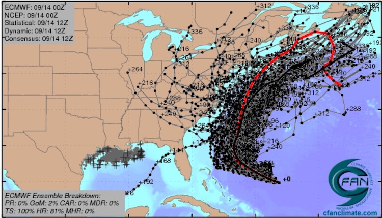
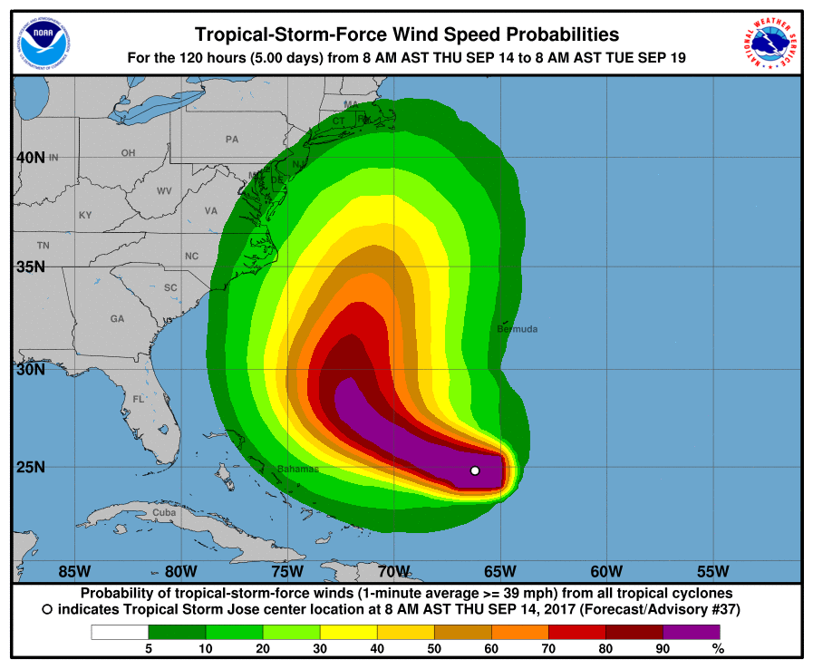
The main forecast challenge is how close Jose will get to the U.S. and Canadian coast. The 00Z Thursday runs of the three top track models all place Jose within several hundred miles of North Carolina’s Outer Banks by next Tuesday. Later in the week, Jose could make an even closer pass by Cape Cod and the Canadian Maritimes. At this point we can’t rule out the possibility that Jose will make landfall somewhere along the east coast of the U.S. or Canada. Of the 50 members of the 00Z Thursday ensemble run of the European model, a substantial minority bring Jose inland across the eastern U.S. (see Figure 3). However, only about 20% of the GFS ensemble members produce an eastern U.S. landfall (see Figure 2). The model guidance trended slightly westward overnight, so we’ll need to keep a close eye on any further trends in model guidance. NHC’s 5-day forecast on Thursday morning placed Jose about 250 miles east of North Carolina on Monday, and the “cone of uncertainty” included the Outer Banks.
 |
| Figure 2. The 20 track forecasts for Jose from the 0Z Thursday, September 14, 2017 GFS model ensemble forecast. Only 5 of the 20 tracks predict an eventual U.S. landfall. Image credit: CFAN. |
 |
| Figure 3. The 0Z Thursday, September 14, 2017 track forecast by the operational European model for Jose (red line, adjusted by CFAN using a proprietary technique that accounts for storm movement since 0Z Thursday), along with the averaged track of the 50 members of the European model ensemble (heavy black line), and the track forecasts from all 50 members of the ensemble. The majority of the forecasts keep Jose offshore. Image credit: CFAN. |
Jose appears most likely to be a Category 1 hurricane on its closest approach to the U.S. and Canada next week, with a gradually expanding wind field, although models suggest it could be a tropical storm or a Category 2 hurricane. Regardless of whether Jose makes landfall, the East Coast is in for several days of big swells, rough surf, and rip currents, starting as soon as this weekend. Seas could reach 10 feet across the Outer Banks from Saturday into early next week. High seas and swells will also reach Bermuda and parts of the Bahamas over the next several days.
 |
| Figure 4. The five-day odds of tropical-storm-force winds (sustained at 39 mph) along Jose’s predicted path through Tuesday. The highest probabilities through Tuesday on the U.S. mainland (around 20%) are along the Outer Banks of North Carolina. Image credit: NHC. |
 |
| Figure 5. Infrared satellite image of the systems dubbed 96L and 97L in the eastern tropical Atlantic as of 11 am EDT Thursday, September 14, 2017. Image credit: NOAA/NESDIS. |
Elsewhere in the Atlantic: Watching 96L and 97L
Two systems in the eastern Atlantic have some potential to develop over the next week, as we remain near the climatological peak of the Atlantic hurricane season. The stronger of the two on Thursday was Invest 97L, located several hundred miles southeast of the Cabo Verde Islands. This wave features a large area of convection with an increasing amount of spin evident in satellite imagery. For the next 2-3 days, the odds will be in 97L’s favor, with wind shear dropping to around 10 knots in a fairly moist atmosphere (mid-level relative humidity of 60-70%) atop sea surface temperatures (SSTs) of close to 29°C (84°F). Wind shear is predicted to increase sharply by Monday, to the 20 – 30 knot range, and this would likely inject dry air into the system, so 97L has a fairly brief window for organizing. In its tropical weather outlook at 2 pm EDT Thursday, NHC upped the short-term odds of development considerably, giving 96L a 60% chance of becoming at least a tropical depression by Saturday and a 70% chance by Tuesday.
About 800 miles west of 97L was Invest 96L, a less impressive-looking wave with a large but loosely organized zone of convection. In spite of its ragged state, 96L is embedded in a moist atmosphere, with mid-level relative humidity of about 70%, and wind shear will drop from about 15 knots on Thursday to around 10 knots on Friday and Saturday. Together with adequately warm SSTs of around 28-29°C (82-84°F), this may give 96L a chance to organize, especially over the weekend. Both the European and UKMET models from 00Z Thursday developed 96L into a tropical cyclone. The 0Z GFS did not, but the 6Z and 12Z runs did. The Euro tracked 96L well north of the Leeward Islands as a tropical storm, while the UKMET and GFS suggested a more westerly track that would potentially affect the Lesser Antilles early next week. About a quarter of the 50 Euro ensemble members from 00Z Thursday tracked 96L north of the Leewards as a tropical storm, but only one brought the system to hurricane strength, and there was virtually no support for 96L within the GFS ensemble. In its tropical weather outlook at 2 pm EDT Thursday, NHC gave 96L a 20% chance of becoming at least a tropical depression by Saturday, but a 70% chance by Tuesday.
 |
| Figure 6. Visible GOES-16 image of Hurricane Max as of 11:45 am EDT Thursday, September 14, 2017. Image credit: NASA/MSFC Earth Science Branch. |
Quick-forming Hurricane Max pushing inland along Mexico’s southwest coast
Hurricane Max, which vaulted from tropical depression to Category 1 strength in less than 24 hours, is buffeting coastal residents and tourists near Acapulco with strong winds, heavy rain, and rough surf. As of 11 am EDT Thursday, Max was centered just 40 miles south of Acapulco, moving east at 7 mph. Max is expected to begin angling toward the east-northeast later today and should make landfall on Thursday night. Because the Mexican coast angles east-southeast near Acapulco, Max’s landfall will be very gradual, prolonging a period of very heavy rain near the coast and just inland. Amounts could total 20” in some coastal areas from Acapulco eastward. Fortunately, Max is a very small storm, with hurricane-force winds extending just 10 miles from its center and tropical-storm-force-winds out to 45 miles. At 11:45 am EDT, the Acapulco International Airport reported winds from the north at 33 mph, gusting to 45 mph. Max’s small size could allow it to strengthen a bit more before landfall, as it moves over very warm SSTs (around 30°C or 86°F) with moderate wind shear (about 10 knots).
Roughly 1000 miles west of Max over the open northeast Pacific, we have another potential landfall in the works with newborn Tropical Storm Norma. As it drifts northward over the next couple of days, Norma appears likely to strengthen into a hurricane, with SSTs of around 29°C (84°F) and light to moderate wind shear (5- 10 knots). The 12Z Thursday SHIPS model gives Norma a 15-25% chance of rapid intensification through Saturday. Norma’s forward speed will accelerate this weekend, and it could reach southern Baja California as a hurricane by Monday. Moisture from Norma may spread into parts of the Southern Plains and enhance rainfall ahead of a strong upper-level trough by midweek.
Even further to the west, Tropical Depression 15E is taking its time organizing. 15E is likely to meander through the open waters of the Northeast Pacific as a tropical depression or weak tropical storm into early next week, posing no threat to land. Yet another disturbance west of 15E is unlikely to develop in the next several days.
 |
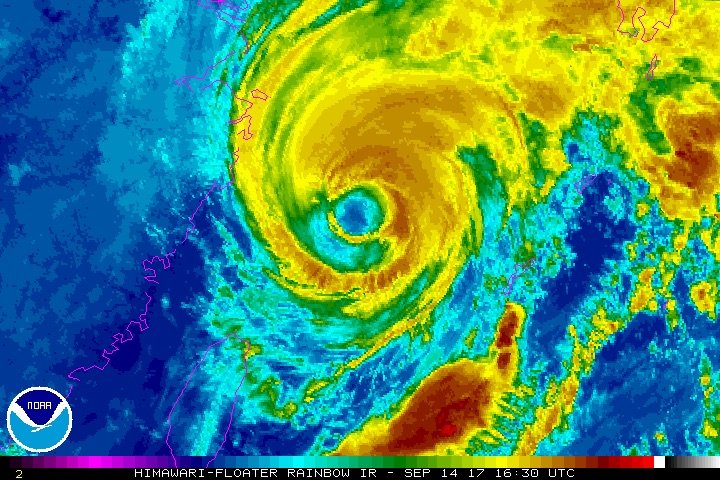
| Figure 7. Himiwari-8 enhanced-infrared satellite image of Typhoon Talim at 12:30 pm EDT Thursday, September 14, 2017. Image credit: NOAA/NESDIS. |
Typhoon Talim heading for Japan
Packing the sustained winds of a Category 3 hurricane (125 mph), Typhoon Talim is rounding the bend just east of China and is expected to rake southwest Japan as a weakening but still-potent system in about 3-4 days. Talim’s path wound its way clear of Okinawa, but the typhoon struck Japan’s southern Ryukyu islands. As reported by weather.com, the Shimoji airport measured wind gusts to 114 mph, and the Miyako-Jima Island airport racked up a record 18.86” of rain in 24 hours, with wind gusts of up to 108 mph. Very heavy rains can be expected in southwest Japan, and tropical-storm-force winds may reach Tokyo by late Sunday. Meanwhile, Typhoon Doksuri, now packing top sustained winds of 100 mph, will bring very heavy rains (locally 20” or more) to parts of central Vietnam and Laos after it makes landfall on Friday along the coast of central Vietnam as a Category 1 or 2 typhoon.


