| Above: Radar image from the Cayman Islands radar of Alberto taken at 5:15pm EDT May 25, 2018. |
Subtropical Storm Alberto, which formed Friday morning along the eastern coast of the Yucatan Peninsula, is in no hurry to move or intensify. An Air Force hurricane hunter aircraft investigating Alberto on Friday afternoon found the storm to be poorly organized, with top winds well below tropical storm-force. However, two ships in the Yucatan Channel between Cozumel, Mexico and the western tip of Cuba reported sustained winds of 39 – 40 mph at 2 pm EDT, according to the National Data Buoy Center. Update: As of 11 pm EDT Friday, Alberto's top sustained winds remained at 40 mph, and it had moved just slightly eastward in the preceding few hours.
Satellite loops on Friday afternoon showed that Alberto had a modest area of heavy thunderstorms to the northeast of its center; this activity was well removed from the center of circulation, something that is characteristic of a subtropical cyclone. These thunderstorms were bringing heavy rain to Cuba, as seen on Cuban radar, and to the Cayman Islands, as seen from their radar. The eastern Yucatan Peninsula of Mexico received over 3 inches of rain from pre-Alberto during the 3-day period ending on Thursday. A personal weather station (PWS) on the northwest end of Grand Cayman Island recorded 1.39” of rain as of 5 pm EDT Friday.
Wind shear over Alberto was a high 25 knots on Friday afternoon, which is hostile for development, and dry air was wrapping into the west side of the circulation, which was also hindering development. Sea surface temperatures (SSTs) were near 28°C (82°F), which is favorable for development. The atmosphere on the east side of Alberto was quite moist, with a relative humidity at mid-levels of the atmosphere of 70%--favorable for development.
Map of Atlantic named storm formation locations during May since 1851 including newly-formed #Alberto. pic.twitter.com/tLyjaNf4nE
— Philip Klotzbach (@philklotzbach) May 25, 2018
Climatology of May named storms
According to Dr. Phil Klotzbach (CSU), since 1950, there have been 14 years with named storms in May--an average of one May storm every five years. Those 14 years had near-average activity for the entire season, so a May storm is not necessarily a harbinger of an active hurricane season to come. He also reports that the earliest date the U.S. has seen a hurricane landfall since record-keeping began in 1851 is June 9, 1966, when Category 2 Hurricane Alma hit Florida. Wunderground member Mark Cole reported this interesting stat: 2018 is the fourth season in a row for the Atlantic to see a named storm before the official June 1 start of hurricane season. That has happened only one other time in recorded history, back in 1951 – 1954:
YEAR DATE NAME
1951 Jan 4 Tropical Storm One
1952 Feb 3 Tropical Storm One
1953 May 25 Tropical Storm Alice
1954 May 28 Tropical Storm One
2015 May 8 Tropical Storm Ana
2016 Jan 12 Hurricane Alex
2017 Apr 19 Tropical Storm Arlene
2018 May 25 Subtropical Storm Alberto
 |
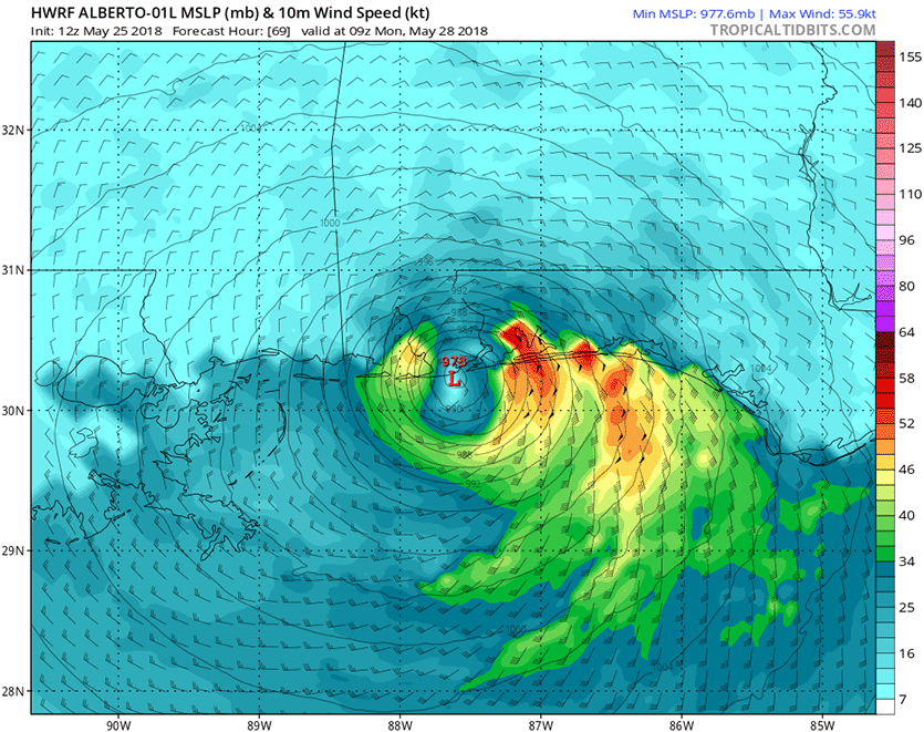
| Figure 1. Predicted wind speed (knots) for Alberto at 9Z Monday, May 28, 2018 (5 am EDT) as predicted by the 12Z Friday, May 25, 2018 run of the HWRF model. The forecast shows Alberto’s tropical storm-force winds (green colors, 34 knots and above) affecting a 200-mile stretch of the Gulf Coast from the Mississippi/Alabama border to Apalachicola, Florida. Peak winds in this run were about 65 mph; this model was our top-performing intensity model in 2017, and this is a believable forecast. Note that the wind distribution is asymmetric, with a larger area of strong winds on the storm’s east side. This is occurring because of wind shear and dry air affecting the west side of the storm. Image credit: Levi Cowan, tropicaltidbits.com. |
Model predictions in decent agreement
The 12Z Friday operational runs of our top four models for predicting tropical cyclone tracks--the European, UKMET, GFS and HWRF models (see my post last Friday on model performance in 2017)--all show Alberto moving north-northeast, then north, then north-northwest, as it traverses the Gulf of Mexico over the weekend. This track will bring the center to a landfall somewhere between Southeast Louisiana and the western Florida Panhandle on Monday. The exact location of Alberto’s landfall is not going to be all that important, since the main impact of the storm will be heavy rain, which will impact this entire stretch of the Gulf Coast, regardless of the exact track. Note that Alberto’s current asymmetry—with most of the strong winds and heavy rains on the east side of the center—will continue until landfall on Monday. This asymmetry is due to wind shear and dry air affecting the west side of the storm.
The latest 12Z and 18Z Friday runs of our top five intensity models (the HWRF, DSHIPS, COAMPS-TC, LGEM and HMON models) predicted that Alberto would intensify until landfall on Monday, with peak winds on Monday ranging from 60 mph (LGEM model) to 77 mph (HMON model). None of the 50 ensemble members of the 0Z Friday European model forecast or the 20 members of the 0Z Friday GFS forecast predicted that Alberto would become a hurricane, though the operational 12Z Friday run of the GFS model did. I give Alberto a 20% chance of becoming a hurricane. The 5 pm EDT Friday NHC advisory called for Alberto to peak with 65 mph winds on Monday. A tropical storm watch was in effect from Grand Isle, Louisiana, to Indian Pass, Florida, including Lake Pontchartrain and Lake Maurepas, as well as for Mexico's Yucatan coast from Tulum to Cabo Catoche and for the Cuban province of Pinar del Rio.
 |
| Figure 2. Predicted precipitation for the 7-day period ending at 8 pm EDT Friday, June 1, 2018. Alberto is predicted to bring rainfall amounts of 3 - 5 inches to most of the Southeast U.S. Image credit: National Weather Service. |
Heavy rains the main threat
The counter-clockwise flow of air around Alberto, in combination with a very wet tropical airmass, will funnel large amounts of tropical moisture over Cuba and the Southeast U.S., resulting in very heavy rains during the coming week. Adding to the rainfall potential will be the likelihood that Alberto will bump into a strong ridge of high pressure to its north early next week, which would block the storm’s progress and result in a slow movement. The Friday afternoon precipitation guidance from the National Weather Service (Figure 2) shows that 3 – 5” of rain are expected over the next 7 days over much of the Southeast U.S.
A storm surge in excess of three feet is likely in Florida's Apalachee Bay from Alberto late Sunday and early Monday. A storm surge watch is in effect from the mouth of the Mississippi River east to Horseshoe Beach, Florida.
Keeping an eye on Lake Okeechobee
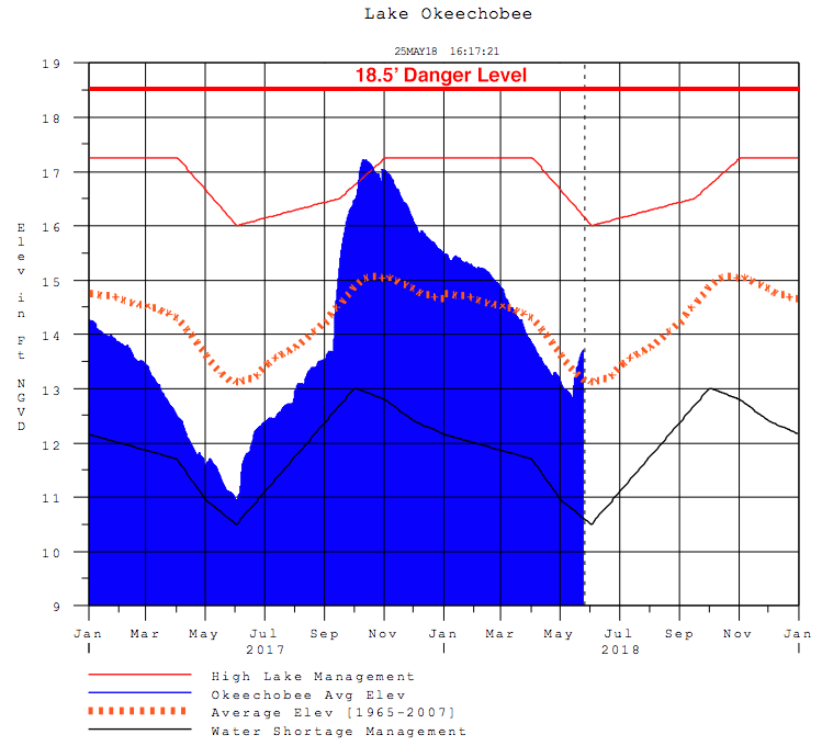
The water level on Florida’s Lake Okeechobee is often a concern during hurricane season, due to the old and frail 143-mile long Herbert Hoover Dike that surrounds the lake. Last year, Hurricane Irma’s rains helped bring the water levels in the lake to the highest level seen in ten years, raising concerns that the dike could fail (see my September 28, 2017 post, Lake Okeechobee Nears Highest Water Level in 10 Years). The lake hit an elevation of 17.2’ above mean sea level (MSL); the dike is at risk to fail when the lake hits 18.5’ above MSL, so we came uncomfortably close to the danger point. Fortunately, no more hurricanes hit Florida after Irma, and the Army Corps was able to lower the lake rate at their maximum rate of about 0.4" per day to draw down the dangerously-high water levels. The Corps is in the middle of a $1.8 billion project to upgrade the dike; $940 million of that total has been spent since 2001 to build 21 miles of seepage barrier and replace over 20 water control structures, mostly on the south side of the lake.
 |
| Figure 3. Water level of Florida's Lake Okeechobee between January 2017 and May 25, 2018. Rains from last week’s tropical disturbance have raised the lake level by more than 10” since May 13. The Army Corps tries to keep the lake level below 15.5'; the dike surrounding the lake is in danger of failure when the lake level hits 18.5' (red line), and is likely to fail when the water level hits 21'. When the lake level hits 17’, the Corps switches from weekly inspections of the dike to daily ones. Lake Okeechobee reached an elevation of 18.6' and 18.5' in 1995 and 1998, and since its construction in 1931, has never been above 18.7’. Image credit: Army Corps of Engineers. |
This year, Lake Okeechobee started out at near-average water levels, but is now considerably above average--about 13.8’ above MSL on May 25. According to a May 22 article in tcpalm.com, the Army Corps likes to have the lake level be around 12.5’ on June 1, to give them plenty of flexibility to manage water levels during hurricane season. Heavy rains from last week’s tropical disturbance, which dumped about 3 – 4” of rain over the lake’s watershed, have increased the lake levels by over 10” since May 13, though; each 1” of rain that falls in the watershed raises Lake Okeechobee’s water level by about 4”, over a period of about two weeks following the rains.
Additional heavy rains of 3 – 4” from Alberto can be expected to raise lake levels by at least another foot, potentially bringing the lake a point where significant dumping of water by the Army Corps will be needed--for the third year in a row. These waters are laden with pollution that causes significant water quality issues along both coasts of Florida, triggering algae blooms and beach closures. Weather.com did an excellent interactive look at the issue back in December 2016.
Bob Henson will have a new post on Alberto on Saturday.


