| Above: Flames rise behind a vacant house as a firefighter works to halt the Detwiler wildfire near Mariposa, Calif., on Wednesday, July 19, 2017. Image credit: AP Photo/Noah Berger. |
One of the largest evacuations in British Columbia history is underway, thanks to 155 wildfires—including fifteen major wildfires that threaten populated areas—that have forced more than 45,000 people from their homes. According to CBC News, the number of evacuations is approaching the province’s record set in 2003, when 50,000 people were forced out of their homes by a wildfire near Kelowna. The Canadian Interagency Forest Fire Centre reported on July 19 that the nation was operating at the highest level of wildfire response, Level 5, and that international assistance would likely be needed, since “national resource levels are insufficient to meet occurring and anticipated wildland fire activity.” A state of emergency was declared for the province on July 7, and has been extended through the end of July.
The fires have created suffocating smoke in British Columbia and Alberta all week, causing dangerous levels of tiny particles known as PM2.5 (less than 2.5 microns or 0.0001 inch in diameter). PM2.5 pollution causes over 80,000 premature deaths each year in the United States. The worst PM2.5 air pollution levels on Wednesday were at Williams Lake Columneetza School, in Central British Columbia, which reported 24-hour average levels of 308 micrograms per cubic meter. This is nearly nine times higher than the U.S. EPA 24-hour standard of 35 micrograms per cubic meter, and falls solidly in the highest level of alert category, “Hazardous.” Air pollution levels in the “Hazardous” range can cause serious health effects in the entire population, leading to health warnings of emergency conditions.
 |
| Figure 1. True-color MODIS image of smoke and fires (red squares) in British Columbia, Canada, at 3:35 pm EDT July 18, 2017. Image credit: NASA. |
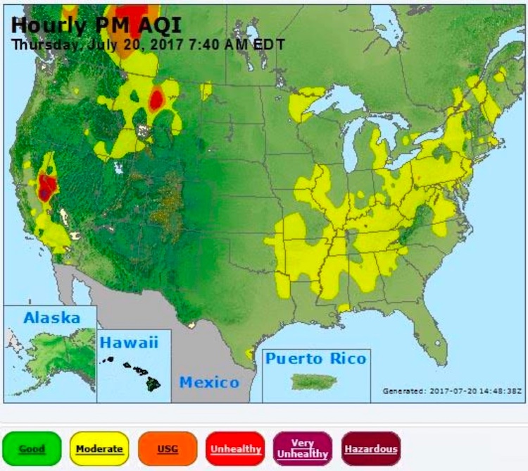
Smoke from the fires has been transported over much of Canada and the U.S. this week, including Alaska. On Thursday morning, smoke from the fires was responsible for PM2.5 levels in the red “Unhealthy” range in central Montana and much of Alberta, including the city of Edmonton. According to the EPA, if sustained for 24 hours, this “red zone” air quality will cause increased aggravation of heart or lung disease and premature mortality in persons with cardiopulmonary disease, and the elderly, and will also cause increased respiratory effects in the general population.
Conditions in the fire zone are considered “Abnormally Dry”, according to the latest North American Drought Monitor. At least 30% of the British Columbia fires were spawning by lightning. The latest forecast for central British Columbia calls for mostly dry weather with high temperatures in the mid- to upper-80s during the next ten days, which will not help with fire-fighting efforts. Fortunately, winds are expected to be light, which will help keep the blazes from spreading.
Detwiler Fire threatens California’s historic town of Mariposa
A state of emergency was declared on Wednesday in Mariposa County, including parts of Yosemite National Park, as the Detwiler Fire doubled in size in just one day to encompass roughly 46,000 acres on Wednesday. The fire had expanded to 70,000 acres by Thursday morning, with just 10% containment, and 45 structures had already been lost, according to CalFire. The Merced Sun-Star reported that more than 3100 firefighters were being coordinated from an incident command post at the Merced County Fairgrounds. In the crosshairs of the spreading fire on Thursday was Mariposa, a Gold Rush-era town of about 2000 residents and 4000 structures. The town was almost completely evacuated on Wednesday.
Thick smoke from the fire streamed into Yosemite, cutting visibility and raising air quality concerns. The Air Quality Index (AQI) reached “very unhealthy” levels by Wednesday night close to the fire. “Unhealthy” conditions extended northeast from the fire across the Reno, Nevada, area. An AQI in the unhealthy range can bring adverse effects to anyone, with those in sensitive groups at even greater risk.
The forecast for Mariposa calls for hot, dry weather over the coming ten days, with highs soaring to 100°F by Saturday. Winds should mostly be light, though, which will aid fire-fighting efforts. The NOAA/NWS Storm Prediction Center introduced an area of critical fire weather risk on Thursday morning across parts of north central Montana, but there were no other areas of critical or extreme conditions in Thursday's 1- and 2-day fire weather outlooks. In the longer term, there is no major relief in sight for generally hot and dry conditions across the western U.S., as a strong upper-level dome of high pressure intensifies into the weekend. The 6-to-10-day and 8-to-14-day outlooks from the National Weather Serivce show warmer-than-average conditions across most of the U.S. West.
 |
Figure 2. Concentrations of fine particles less than 2.5 microns in diameter (PM2.5) observed on Thursday, July 20, 2017, at 7:40 am EDT. Smoke from a fire in Central California was creating PM2.5 levels in the purple “Very Unhealthy” range near Yosemite National Park, and smoke from fires in British Columbia were causing PM2.5 levels in the red “Unhealthy” range in central Montana and over much of Alberta, including the city of Edmonton. Image credit: U.S. EPA. |
Wet winter sets the stage for a dangerous fire season in parts of U.S. West
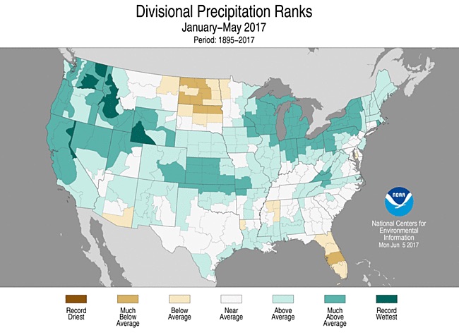
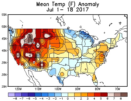
The generous rains and mountain snows of the winter of 2017—so welcomed by people from California to Wyoming—are now proving to have been a double-edged sword. The moisture led to a growth spurt in the grasses and shrubs across rugged landscapes of the West that typically dry out in the summer. The exceptionally wet cool season has segued into a viciously hot, dry summer that’s turned the unusually lush landscape into fuel ripe for a fire.
 |
| Figure 3. Parts of four U.S. states had their wettest January-to-May period in more than a century of recordkeeping. Image credit: NOAA/NCEI. |
 |
| Figure 4. Temperatures across many parts of the U.S. West were running 4-8°F above average for the month through July 18. Image credit: NOAA/NWS/WPC. |
In its national wildland fire outlook for July through October, the National Interagency Fire Center is calling for above-average fire risk over parts of California, Nevada, Utah, Idaho, Montana, and the Dakotas. “Timely precipitation along with above average soil moisture has led to the growth of an abundant crop of fine fuels across much of the west,” the center noted. In California, the elevated fire risk includes parts of the Coast Range in and near the San Francisco Bay area, as well as mountainsides adjoining the San Joaquin Valley. The risk will be greatest at elevations below 6500 feet, as fuels in the higher elevations may not fully dry out this summer.
The Detwiler fire is expanding into huge swaths of trees killed by the 2011-16 drought and an accompanying bark beetle epidemic. These trees may burn more readily than those still alive, which benefited from the winter moisture. Surprisingly, it doesn’t appear that beetle epidemics lead to a greater coverage of wildfire. Fires that do reach the beetle-felled areas may burn more intensely, especially in the first several years after tree death. Even in this case, research has been mixed—in part because the most extreme fire weather tends to dry out the entire landscape, thus reducing the effect of the beetle kill.
Dr. Jeff Masters co-wrote this post.


