| Above: A spectacular GOES-16 low-level water-vapor satellite image of the midlatitude storm system spinning across the central U.S. at 5:17 pm CDT Sunday, April 30, 2017. Data from GOES-16 is non-operational and preliminary, as the satellite is still undergoing testing. Image credit: College of DuPage. |
A classic midlatitude spring storm churned its way across the midsection of the United States over the final weekend of April, killing at least 15 people in 5 states. The system’s threats were multifaceted: torrential rain and flooding, deadly lightning, downburst winds, and at least two strong tornadoes.
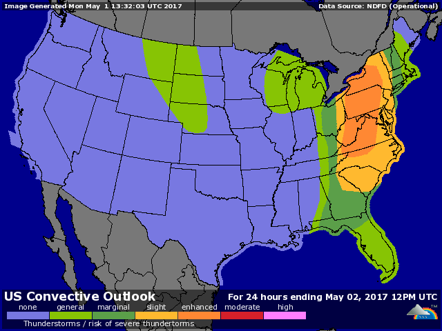
In textbook fashion, the midlatitude storm was occluding on Monday, with a cold front racing well ahead of the increasingly stacked upper- and low-level centers of low pressure over the Midwest. That cold front may still produce one more day of severe weather from the Appalachians eastward. Early Monday, the NOAA/NWS Storm Prediction Center placed most of the region from Virginia to New York under an enhanced risk of severe weather. This zone was enveloped by a larger slight-risk area that included the DC-to-NYC corridor as well as many inland cities from Charlotte, NC, to Burlington, VT (see Figure 1). A line of thunderstorms should plow across the region on Monday afternoon and evening, packing strong downburst winds and pulses of heavy rain. Tornadoes aren’t likely to be numerous, but they are possible within small-scale vortices along the squall line or in any isolated supercell storms that develop ahead of the line.
 |
| Figure 1. NOAA/NWS/SPC outlook for severe weather on Monday, May 1, 2017, updated at 8:00 am CDT. |
Ozarks hammered by record-high flood crests
Widespread three-day rains of 5” – 10” and more pushed creeks and streams across the central U.S. out of their banks, and in many cases to unprecedented heights (see this comprehensive list from weather.com’s Jon Erdman). The disruption from closed roads and flooded structures in and near Missouri may end up on par with that produced by massive flooding not much more than a year ago, in December 2015.
Highest rainfall totals from noon CDT Friday through 3:00 am Monday included:
Houston, MO (4.5 miles ESE): 11.15”
Rogers, AR: 10.54”
Bunkie, LA: 10.00”
Savoy, OK (3 miles SE): 8.50”
Owensville, IL: 7.95”
 |
| Figure 2. 24-hour precipitation totals through 7 am CDT Sunday, April 30, 2017, included widespread rainfall amounts of 3” to 8”. Image credit: NOAA/NWS/AHPS. |
As was predicted last week, the epicenter of heavy rain and flooding stretched from far eastern Oklahoma across the Ozarks of southern Missouri and northwest Arkansas. At least seven flood-related deaths have been reported in the latter two states, according to weather.com, including two children missing after a vehicle was swept from a roadway near Hindsville, AR.
Water is now pouring eastward across the region toward the Mississippi Valley, and several more inches of rain expected later this week could exacerbate the situation. At Cape Girardeau, MO, the Mississippi River is projected to crest on Saturday at its second-highest level on record, just a few inches shy of the 48.9-foot level set on January 2, 2016. The city has ample protection from a 55-foot flood wall, but many road closures can be expected across the region, reported the Southeast Missourian.
 |
| Figure 3. This weekend’s storm smashed the previous record crest of the Current River at Doniphan, MO, of 26.80 feet, set on March 1, 1904. The water level had reached 32.69 feet as of 6:30 AM CDT, with additional rise expected on Monday. Image credit: NOAA/NWS Advanced Hydrologic Prediction Service. |
Vicious tornadoes strike in East Texas
At least four people were killed, two were missing, and dozens were injured after multiple tornadoes struck parts of northeast Texas on Saturday evening. The worst was in Van Zandt County, where two weak tornadoes around 4:15 pm CDT were followed by two far more damaging twisters around 5:30 pm. The latter were both given preliminary damage ratings of EF3 after storm survey teams made their way through the wreckage on Sunday. One of those EF3s was a long-track tornado, with a path length that may have been continuous for 51 miles.
 |
| Figure 4. Significant damage occurred in Canton, TX, from a tornado on Saturday, April 29, 2017, as documented by an NWS storm survey team on Sunday, April 30. Image credit: NOAA/NWS. |
The long-track tornado was a highly visible “wedge” photographed by many residents and storm chasers. It caused major damage in Canton, about 60 miles east of Dallas, and tossed cars off several highways that crisscross the region, killing at least one motorist. A barnlike structure was demolished only an hour before it would have been packed with high-school prom-goers, but the 20 people already in the building escaped unharmed, according to the Dallas Morning News.
Ferocious late-season blizzard socks the High Plains
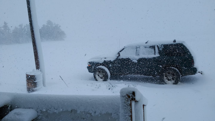
The central U.S. storm system dumped more than two feet of snow on the high country of southern Colorado, which isn’t all that unusual for late April. The real eye-opener was the extension of heavy snow, together with screaming winds gusting well above 40 mph, into western Kansas, the Oklahoma Panhandle, and the far northern Texas Panhandle. If the winds are blowing in this wide-open region, it doesn’t take much snow at all to produce blizzard conditions. In this case, the snowfall was more than ample.
 |
| Figure 5. Tabbiy Anne Russell posted this image from her yard in Angelus, KS, to the NWS Facebook page in Goodland, KS, on Sunday, April 30, 2017. Image credit: Courtesy Tabbiy Anne Russell. |
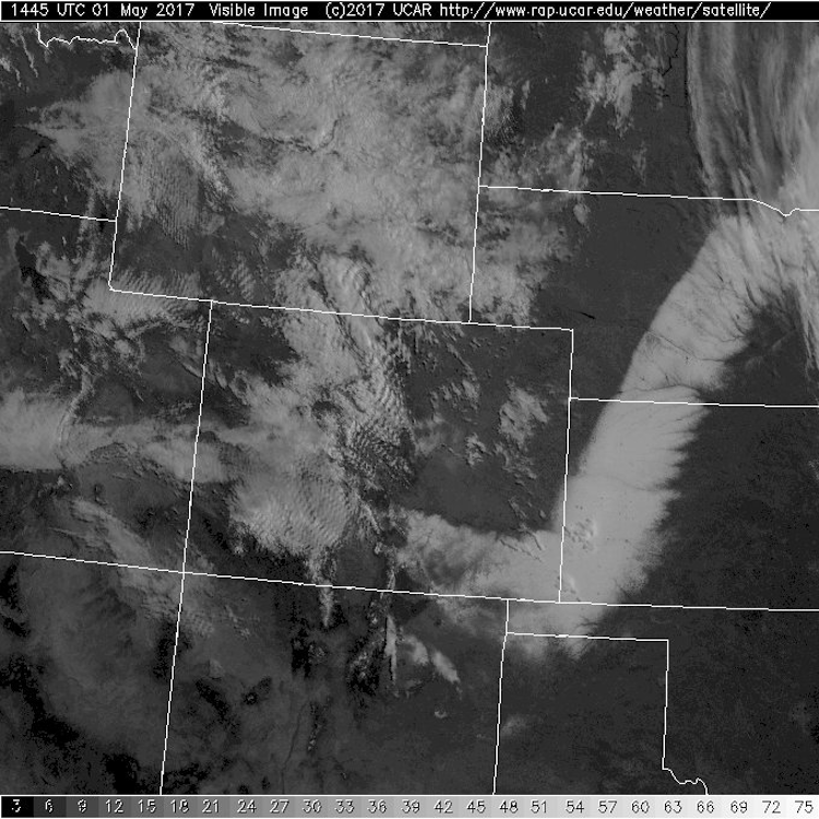
Depth measurements are notoriously unreliable in blizzard conditions, because drifting is so widespread, but radar and satellite data support the idea that snowfall was quite substantial across far western KS. There are preliminary reports that as much as 20” fell near Colby, KS, with a corridor of foot-plus totals reported west of a line from around Garden City to Colby. Dalhart, TX, reported at least 9”. The NWS office in Dodge City called the widespread heavy amounts unprecedented for so late in the spring.
Even the modest 2.5” officially reported on Sunday at Dodge City itself marked the first time a spring snowfall has exceeded 1” in Dodge City on any calendar day after April 15. Records began at Dodge City in 1893. Interestingly, the temperature never dropped below 32°F during the entire event at Dodge City, so Sunday’s record low of 20°F was untouched, though the city did set a record-low daily maximum of 37°F.
 |
| Figure 6. The band of heavy snow left across the High Plains by Sunday's blizzard, extending from the Texas Panhandle to Nebraska, pops out dramatically on this visible satellite image from Monday morning, May 1, 2017. Image credit: NCAR/RAL Real-Time Weather Data. |


