| Above: Emmaline Dendinger enjoys a hearty bite of snow in Jackson, Miss., on Friday, Dec. 8, 2017. Image credit: AP Photo/Rogelio V. Solis. |
A swath of high-impact snowfall—in some places, among the heaviest ever observed—made its way from South Texas to Atlanta on Friday, en route to the big cities of the Northeast U.S. (see below). Meanwhile, massive wildfires continued to scorch the landscape of Southern California, raging at unprecedented scope for December. It’s an odd juxtaposition, driven by a highly amplified weather pattern. Winds at the jet-stream level on Friday were blowing from the Canadian Arctic south across the Great Plains all the way to Mexico (see Figure 2).
Perhaps surprisingly, this pattern hasn’t produced many U.S. record lows, and few are in the offing for the next few days. The strong northerly jet hasn’t managed to pull a truly bitter Arctic air mass into the 48 states. Instead, the central and eastern U.S. are heading into a few days of consistent but less-than-brutal cold, while very mild, dry air continues to blow offshore across coastal California, stoking the fire threat.
 |
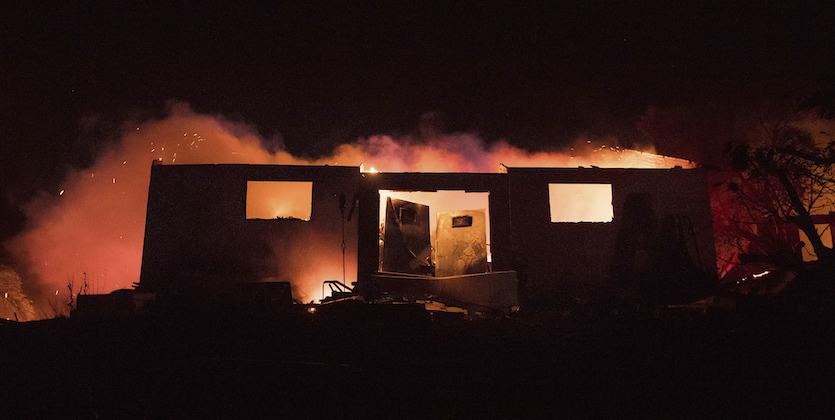
| Figure 1. Flames consume a residence as the Lilac Fire burns in Bonsall, Calif., early Friday, Dec. 8, 2017. As of Friday afternoon, the fire had consumed 4100 acres and was 0% contained. Image credit: AP Photo/Noah Berger. |
 |
| Figure 2. Winds at the 500-mb level, about four miles above the surface, were streaming from far northern Canada southward to Texas at 12Z (7 am EST) Friday, December 8, 2017. Image credit: tropicaltidbits.com. |
Much of the nation is drying out—quickly
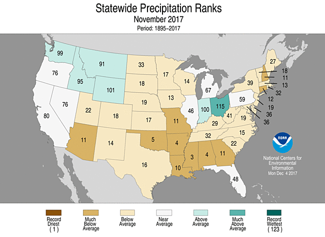
Last month was the 19th driest November in U.S. records dating back to 1895. Outside of the Northwest and the eastern Great Lakes, most of the contiguous U.S. was drier than average (see Figure 3 below), with large swaths of “much below average” precipitation. A mere 0.08” of moisture was observed in Lincoln, NE, from October 15 through December 7; it’s the least precipitation on record for that interval, in data going back to 1887 (the runner-up is 0.23” in 1976).
Over the two weeks ending December 5, the U.S. Drought Monitor showed a dramatic leap in drought coverage. The percentage of the nation experiencing at least some level of drought has vaulted from 15% to 24%. Leaps of this magnitude do happen, but they’re more common in spring and summer, when high temperatures, intense sunshine, and low humidity can quickly dry out the landscape.
 |
| Figure 3. Statewide precipitation rankings for November 2017. A ranking of 123 indicates the wettest November observed since 1895; a ranking of 1 denotes the driest. Image credit: NOAA/NCEI. |
In recent years, the concept of “flash drought” has gained enough traction that experts are now working to develop a precise definition. An article now in press at the Bulletin of the American Meteorological Society argues that such a definition ought to hinge on how quickly a drought develops rather than on how brief the drought ends up being. In this light, the quick spread of drought conditions over the last several weeks is concerning indeed.
Texas goes from unprecedented flood to drought in just 3 months
During the last week of August, Hurricane Harvey stalled over the Houston, Texas area, dumping more than 20 inches of rain in seven days over an area the size of West Virginia; Harvey’s 60 inches of rain near Port Arthur were the greatest on record for any storm in U.S. recorded history. Despite this unprecedented deluge, portions of the region that received 20+ inches of rain are now in drought, according to Thursday’s U.S. Drought Monitor report. Houston and Beaumont/Port Arthur--which received more than 40 inches of rain from Harvey--are now considered “Abnormally Dry”.
 |
| Figure 4. Comparison of drought conditions for the Southern U.S. on August 29, 2017 (left) and December 5, 2017 (right). Image credit: U.S. Drought Monitor. |
A large-scale weather pattern typical of La Niña, which is keeping rain-bearing low pressure systems well to the north, is to blame. Over the past three months, below-average rainfall coupled with monthly average temperatures 5°F above average have led to the drought conditions. Houston had its fourth-driest November on record, according to the Southeast Regional Climate Center, and in an interview in USA Today, Texas State Climatologist John Nielsen-Gammon said that many locations across Texas had one of their 10 driest autumns on record, including Galveston, Waco, and Dallas. He warned: "Fire is the primary potential impact, and wet followed by dry is the standard recipe for lots of dry fuels. Other problems are related to lack of establishment of winter pasture and (farther north) winter wheat”.
It’s too soon for any water supply impacts, but with NOAA’s Climate Prediction Center predicting that drought will persist or intensify this winter across the nation's southern tier of states, water supply for some portions of Texas could be a problem by spring. The latest runs of the GFS model predict no rain for coastal Texas at least through December 17.
 |
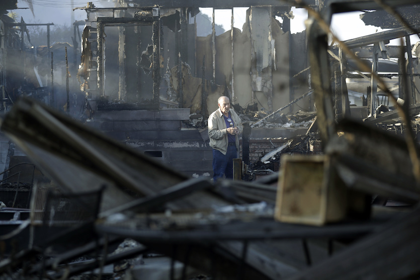
| Figure 5. Dick Marsala looks through debris from his destroyed home on Friday, Dec. 8, 2017, after the Lilac Fire north of San Diego roared through the Bonsall, Calif., area. Image credit: AP Photo/Gregory Bull. |
A historic U.S. and California fire season in 2017
According to the National Interagency Fire Center, 2017 ranked in fifth place as of November 30 for the most U.S. acreage burned by wildfires in a year (since 1960), at 9.2 million acres. This week’s fires in California have added another 157,000 acres as of Friday morning to that total, putting 2017 into third place on the all-time list. Currently, the top five fire years for U.S. acreage burned since 1960 are:
1. 2015 10.1 million acres
2. 2006 9.9 million acres
3. 2017 9.4 million acres
4. 2007 9.3 million acres
5. 2012 9.3 million acres
According to Cal Fire, the 132,000 acres burned as of Friday morning in the Thomas Fire make it California’s largest fire of the year, and tied for 18th largest of any year since records began in 1932. The 439 structures destroyed by the fire are the 19th most of any California fire in recorded history, and the 5th highest of 2017. Five of the twenty most destructive California fires on record have occurred in 2017. The 612,000 acres burned in Cal Fire’s jurisdiction so far in 2017 make it their biggest fire year since 1944, when 649,000 acres burned.
No rain in the forecast (again)
With no sign of any meaningful rains for Southern California over the next two weeks, it is quite possible that some of this week’s wildfires will burn until Christmas and beyond. The upper atmosphere over North America has locked into a pattern with a very strong ridge near the Pacific Coast, and a strong trough in the East, which will force any potential rain-making low pressure systems well north of Central California for at least the next two weeks.
 |
| Figure 6. The 7 am EST (12Z) Friday, December 8, 2017 forecast from the GFS model predicted no precipitation for most of California through Christmas Eve, with less than 1/2” (green colors) falling in portions of Northern and Central California. Image credit: tropicaltidbits.com. Other recent runs of the GFS have painted a similar picture. |
Extremely dry air helping to fuel SoCal fires
The dry air masses sweeping across the country have pushed all the way to the West Coast, leading to extremely low amounts of moisture in the atmosphere. A radiosonde (weather balloon) launched from Portland, OR, at 4 am PST Thursday, Dec. 7, measured just 0.12” of precipitable water (PW) in the atmosphere. It’s the lowest measured on any December 7 in Portland, in radiosonde records going back to 1948. Similarly, San Diego set a daily PW record on Thursday morning with 0.09”. Within just a few miles of the Southern California coast, humidities dipped as low as 4% at some locations, and dew-point temperatures dropped into the –15°F to –20°F range, phenomenally low for any time of year.
Strictly speaking, this wasn’t the driest air mass ever observed in the western U.S. A handful of other dates have seen precipitable water as low as 0.06” in Portland and 0.05” in San Diego. However, the “record driest” distinctions get harder to justify when air gets this arid, because standard humidity-sensing instruments aren’t designed for optimal performance at moisture levels this low.
“I'm not sure how much it matters if we actually hit all-time low values or just got really close to them, which does appear to be the case,” Daniel Swain (California Weather Blog) told me in a Twitter message. “It's definitely the case that Oct-Nov was the warmest and second driest such period on record in coastal Southern California (it was 95°F in Los Angeles the week of Thanksgiving!), and that definitely set the stage for these late-season Santa Ana winds to drive such destructive fires in December.”
Truly a winter wonderland in #AbitaSprings! The sneaux is so beautiful.@MargaretOrr @wdsu @NWSNewOrleans #lanorthshore #lawx #sneauxday pic.twitter.com/i8x0Rv5nKF
— David (@DavidMora) December 8, 2017
Truly a winter wonderland in #AbitaSprings! The sneaux is so beautiful.@MargaretOrr @wdsu @NWSNewOrleans #lanorthshore #lawx #sneauxday pic.twitter.com/i8x0Rv5nKF
— David (@DavidMora) December 8, 2017Unusual snowfall blankets the landscape from the Rio Grande Valley to New Orleans
Low-latitude snow lovers rejoiced while others groaned Thursday and Friday, as a narrow stripe of snowfall produced larger-than-expected amounts from far western and southern Texas into parts of the Deep South. Ironically, the dryness of the air feeding into the cold side of this system may have helped it to produce as much snow as it did so far south. As water vapor condenses into droplets and freezes into ice crystals, it releases heat, which warms the surrounding air. When air is forced upward along a cold front, it cools rapidly until it becomes saturated with moisture. Strong lift—provided in this case by a deep upper-level trough dipping into Texas—can lead to intense “dynamic cooling” until an air mass gets saturated. The drier the atmosphere, the colder the air can get before precipitation starts.
Over the Rio Grande Valley and Gulf Coast of Texas, the snow brought back memories of the record-breaking Christmas 2004 snowstorm, where totals ranged as high as 13” in Victoria. Corpus Christi racked up 5.2” in that storm. Early Friday, southern parts of Corpus Christi picked up reliable reports of as much as 7”, while the city officially recorded just 1”.
Along the Gulf Coast from Houston to New Orleans, Friday’s light snow was the kind you might expect only once a decade or so. It was Houston’s first measurable snow of the 2010s. Further inland, amounts were substantially larger. The 5” at College Station was the city’s heaviest total on any calendar day, and first measurable snow in December, in records going back to 1951. The campus of Louisiana State University in Baton Rouge picked up at least 1.5” to 2”, according to state climatologist Barry Keim. Totals of 3” – 6” were expected in a swath from southern Mississippi to northern Georgia, including parts of the Atlanta area. This weekend, the storm could dump 4” – 6” from central Virginia across the Delmarva area to southern New Jersey and southeastern New England, with somewhat lighter amounts from Washington, D.C., to New York City.
For complete coverage throughout the weekend of this winter storm, dubbed Benji by The Weather Channel, check out weather.com’s dedicated page.
Dr. Jeff Masters co-wrote this post.
The snow is over, but the memory lives forever in the #rgv. For the first time since Santa took his sleigh across the region after midnight on Christmas Eve 2004, all corners saw some accumulation. Thanks to all who shared winter joy with us! #txwx pic.twitter.com/Qw9xBWoQiW
— NWS Brownsville (@NWSBrownsville) December 8, 2017


