| Above: Peak ozone pollution levels for Monday, June 12, 2017, as measured using the Air Quality Index (AQI). An AQI with red colors is “Unhealthy”, meaning everyone may begin to experience health effects, and members of sensitive groups may experience more serious health effects. An AQI in the orange range is “Unhealthy for Sensitive Groups”, meaning members of sensitive groups like the elderly and those with lung disease may experience health effects, but the general public is not likely to be affected. |
The first major heat wave of the summer for the Midwest and Northeast U.S. set numerous daily record highs on Monday, and also brought the worst ozone air pollution of the year to much of the region. Ground level ozone, which is created from chemical reactions between volatile organic carbon (VOC) compounds and nitrogen oxides, is created more readily at warmer temperatures. Monday’s record heat helped these chemical reactions occur faster, resulting in ozone pollution that topped out in the “Unhealthy” range along the coasts of Connecticut, New York and Maine. The heat was accompanied by light winds, which allowed pollution levels to build. These concentrations were as much as 50% higher than the federal standard for hazardous level of ozone, and were capable of causing increased risk of stroke, heart attack and breathing problems for sensitive groups. Even people not unusually sensitive to air pollution could see adverse health effects from pollution levels this high. The other main pollutant of concern, tiny particles known as PM2.5 (those that are less than 2.5 microns or 0.0001 inch in diameter)--which cause over 80,000 premature deaths each year in the U.S.—was not as big of a concern on Monday, since PM2.5 levels stayed below the federal standard.
Hundreds of premature deaths likely from this week’s air pollution
Death certificates never list air pollution as the cause of death. Nevertheless, air pollution is a huge and silent killer: between 91,000 and 100,000 air pollution deaths per year occur in the U.S., according to separate studies done in 2016 by the World Bank and the Health Effects Institute (a U.S. non-profit corporation funded by the EPA and the auto industry). Air pollution deaths are calculated using epidemiological studies, which correlate death rates with air pollution levels. Air pollution has been proven to increase the incidence of death due to stroke, heart attack and lung disease. Since these causes of death are also due to other factors—such as lifestyle and family history—we typically refer to air pollution deaths as premature deaths. A premature air pollution-related death typically occurs about twelve years earlier than it otherwise might have, according to Caiazzo et al., 2013.
Approximately 12,000 of these premature U.S. air pollution deaths each year are from high ozone. Since this week’s high ozone levels are affecting a very large population of tens of millions of people, I expect that the death toll from ozone air pollution this week will be several hundred people. Tuesday, June 13 is going to be another day with poor air quality in the Northeast and Midwest United States, and air pollution action days have been declared for Chicago, Philadelphia, and New York City, as well as parts of New Jersey, Rhode Island, and Massachusetts. Cooler temperatures and increased winds will affect the region on Wednesday and Thursday, causing pollution levels to fall, fortunately.
Record highs for Monday, June 12, 2017
Atlantic City, New Jersey, 94°
Allentown, Pennsylvania, 92° (tied)
Harrisburg, Pennsylvania, 92° (tied)
Lansing, Michigan, 95° (tied)
Worcester, Massachusetts, 90° (tied)
Providence, Rhode Island, 95°
New York City, 93° (tied)
Newark, New Jersey, 97°
Cleveland, Ohio, 93°, (tied)
Albany, New York, 95°
Washington D.C., 95° (tied)
Bridgeport, Connecticut, 93°
According to weather.com, while not a record, Chicago reached 95 degrees on Monday--the first time Chicago had been that hot since Sept. 10, 2013.
 |
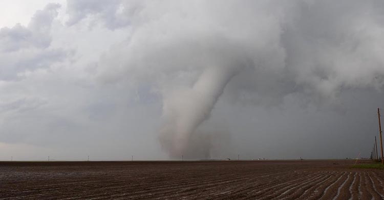
| Figure 1. This twister near Pine Bluffs, WY, was one of several tornadoes produced by a long-lived supercell that developed near Fort Collins, Colorado. The storm remained distinct all the way into extreme southern South Dakota, generating tornadoes along much of its path. Image credit: Scott Landolt. |
Supercells spin off dozens of tornadoes across central High Plains
A swarm of tornadoes pockmarked the High Plains of far northeast Colorado, eastern Wyoming, and western Nebraska late Monday. As of mid-morning Tuesday, the NOAA/NWS Storm Prediction Center had logged 32 tornado reports from Tuesday. Most of the reports were associated with two long-lived supercells, but a few other tornadoes were scattered across Wyoming as far northwest as the Cody area. Several farms and outbuildings were struck across the region, and least two injuries were reported, one in Wyoming and one in Nebraska. A twister that struck near the Nebraska Panhandle town of Angora reportedly knocked 65 train cars off the tracks. Hailstones as large as grapefruits (4.50” in diameter) were reported in southeast WY.
The strong upper-level low responsible for Monday’s severe weather is pushing across the northern Plains today. With plenty of unstable air already in place, severe weather may develop along the associated front and dryline all the way from Minnesota to Texas. Tuesday’s tornado threat is lower than it was on Monday, but a few tornadoes could form, especially toward Minnesota and the Dakotas. In its outlook issued at 7:30 am CDT Tuesday, SPC has an enhanced risk of severe weather in place in the northern Plains region. Another enhanced-risk area was placed along the front and dryline over western Oklahoma and the eastern Texas Panhandle in SPC's 11:30 am CDT update. The surrounding slight-risk belt extends from the Canadian border to very near the Mexican border.
Severe weather should be on the wane later this week as the jet stream weakens and early-summer heat builds.
 |
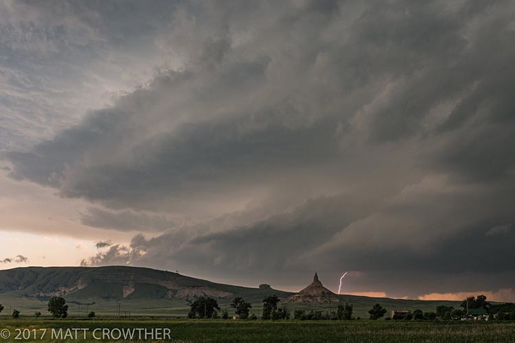
| Figure 2. A cloud-to-ground lightning strike on Tuesday, June 12, near Chimney Rock National Historic Site in far western Nebraska. Photo credit: (c) Matt Crowther. |
Bob Henson contributed the severe weather section of this post.


