| Above: A sofa is seen next to a collapsed house in a tornado-stricken neighborhood on April 30, 2011, in Tuscaloosa, Alabama. An F4 tornado, one of the worst of the 2011 Super Outbreak, tore through parts of Tuscaloosa and Birmingham on Wednesday, April 27, 2011. Damages totaled $2.4 billion. Image credit: Mandel Ngan/AFP/Getty Images. |
As the United States approaches its mid- to late-spring peak of severe weather season, the atmosphere is responding in classic fashion. A very strong, broad, and slow-moving upper-level trough will grind its way across the nation over the next week, bringing a multi-day, multi-threat sequence of tornadoes, hail, high wind, and very heavy rain. The NOAA/NWS Storm Prediction Center has some part of the nation targeted for a severe weather risk on every day from Tuesday, April 25, through Sunday, April 30. The stormy weather could extend into the first week of May.
 |
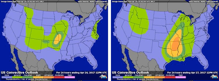
| Figure 1. As of early morning Tuesday, April 25, the NOAA/NWS Storm Prediction Center had placed parts of Oklahoma, Kansas, and Missouri under a slight risk of severe weather for Tuesday. As deeper moisture returns to the region and an upper-level trough approaches, the threat is predicted to expand and intensify on Wednesday, especially across Arkansas, where an enhanced risk of severe weather is projected. Widespread intense tornadoes are not expected on Tuesday or Wednesday, but some tornadoes may occur. A higher threat of significant tornadoes is expected to take shape late in the week. |
A tough stretch on the calendar
Climatologically, the last week of April and the first few days of May are a dangerous period when it comes to U.S. severe weather. One of the nation’s two worst tornado outbreaks on record—the 2011 Super Outbreak—unfolded across the Southeast U.S. from April 25 to 28. Five of Oklahoma’s ten deadliest tornadoes have occurred in the 16-day span between April 25 and May 10. This includes the nation’s first billion-dollar tornado on record: the F5 monster that tore across Moore and neighboring parts of Oklahoma City on May 3, 1999, destroying more than 8000 homes and killing 36.
The atmospheric juxtapositions taking shape later this week, especially toward the weekend, bear many of the hallmarks of a prolonged, significant round of severe weather. CIPS guidance from Saint Louis University, which uses automated algorithms to compare model-based forecasts to prior events, suggests that the best historical analog for the large-scale setup on Friday is the one that prevailed early on April 26, 2011, during the early stages of the 2011 Super Outbreak. No analog is perfect, and subtle variations can make a huge difference in the weather that develops. But simple pattern recognition tells us that the ingredients needed for a major outbreak will be available late this week. It’s mainly a question of how and where those ingredients come together in time and space. Where thunderstorms end up being densely packed over a large area, the threat will skew more toward heavy rain and flooding, whereas more isolated supercell storms will carry a bigger threat for tornadoes.
 |
| Figure 2. Surface (top) and 500-mb (bottom) atmospheric features projected by the 00Z Tuesday run of the GFS model for 00Z April 29, 2017 (left) as compared to the features present at 06Z April 26, 2011, as the 2011 Super Outbreak was getting under way. Image credit: CIPS/Saint Louis University. |
High contrast
Surface temperatures will soar well above 80°F from Dallas-Fort Worth, TX to Washington, DC, by the weekend, which would approach if not exceed record daily highs at many sites. Meanwhile, a pool of unusually cold air within the broad upper-level low will overspread much of the nation. Several inches of snow may fall by Saturday on Denver, Colorado, where 2016-17 has been on track for Denver’s least snowy winter in 135 years of recordkeeping. (Only 19.4” has fallen so far, compared to a record low of 21.3” in 1888-89.)
 |
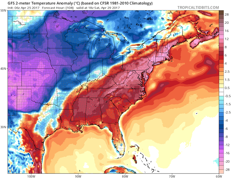
| Figure 3. Temperature departures from average (in degrees C) at midday (1 pm CDT) on Saturday, April 29, as projected by the 06Z Tuesday run of the GFS model. Readings could be more than 15°C (24°F) below average across the southern High Plains and more than 12°C (19°F) above average along the Eastern Seaboard. Image credit: tropicaltidbits.com. |
Accompanying the early-season heat over the Southeast will be an increasingly rich supply of moisture flowing north from the Caribbean and Gulf of Mexico. By Saturday, a corridor from Texas to Ohio is projected to be swathed in an air mass featuring 1.5” to 2.0” of precipitable water (the amount of moisture in the atmosphere above a given point). Such values would be close to the highest on record for so early in the spring and summer.
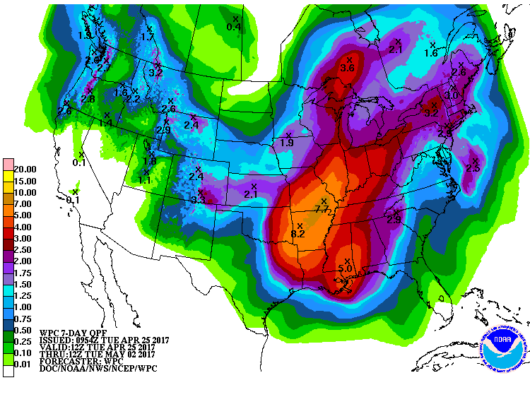
The warmth and moisture building at low levels will lead to very strong instability as the powerful, cold upper trough sweeps across the region by the weekend. Moreover, the slow motion of the upper trough, together with ample moisture, will stoke the potential for very heavy rainfall across a large region centered on the Mississippi Valley (see Figure 4 below).
We’ll be monitoring the situation here at Category 6 as this stormy-looking week unfolds.
 |
| Figure 4. Projected totals of precipitation for the 7-day period from 12Z (8:00 am EDT) Tuesday, April 25, 2017, to 12Z Tuesday, May 2. Image credit: NOAA/NWS Weather Prediction Center. |


