| Above: Probability that a tropical cyclone will form within the shaded regions over the next five days (between 8:00 am EDT Thursday, June 15, and Tuesday, June 20, 2017). Image credit: NOAA/NWS/NHC. |
The odds are increasing that the Gulf of Mexico or Western Caribbean will see formation of a tropical depression early next week. In their 8 am EDT Thursday Tropical Weather Outlook, the National Hurricane Center (NHC) gave 5-day odds of tropical cyclone development of 50% for this region, up from the 20% odds given on Wednesday morning. Satellite loops on Thurday morning showed a steady increase in heavy thunderstorm activity over the Western Caribbean, as a large low pressure system called a “gyre” of low pressure began to form (see the website of SUNY Albany’s Phil Papin, who has developed automated routines to diagnose these gyres). This gyre is expected to move slowly west-northwest to northwest, and will be centered near the east coast of Mexico's Yucatan Peninsula on Sunday. The interaction between this gyre and a tropical wave expected to move into the region this weekend may be enough to trigger formation of a tropical depression by early next week. The next name on the list of Atlantic storms is Tropical Storm Bret.
The 0Z Thursday runs of our top three models for predicting tropical cyclone genesis—the GFS, European and UKMET models—continued to advertise the potential for a tropical cyclone to form. These models have been very persistent in this forecast during the week, giving confidence that such a storm will indeed form. With ocean temperatures in the Western Caribbean and Southern Gulf of Mexico about 1°C (1.8°F) above average, at 29.5°C (85°F), along with wind shear that is predicted to be moderate, conditions will be ripe for development--if the area of low pressure manages to center itself over the water. There is plenty of land in the region to potentially interfere with development, though, and high wind shear may be an issue for the storm later in the week. The large size of the gyre will make it difficult for this system to intensify quickly, since it takes a long time to get such a large mass of air spinning more rapidly. None of the 20 members of the GFS ensemble or 50 members of the European ensemble from the 0Z Thursday runs of these models predicted that the storm would ever reach hurricane strength.
 |
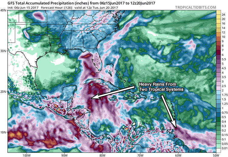
Figure 1. Predicted total precipitation between 2 am EDT Thursday, June 15, and 8 am EDT Tuesday, June 20, from the 6Z June 15 run of the GFS model. Regardless of development of the predicted low pressure gyre over the Yucatan Peninsula into a tropical depression, the large size of the low and the abundant moisture that will feed it from both the tropical Atlantic and tropical Pacific (including the remnants of Tropical Storm Calvin) will generate very heavy rains that will cause flooding and landslide concerns in portions of Central America and Southern Mexico beginning this weekend; rainfall amounts of over six inches (red colors) are predicted in Guatemala, Honduras and Southern Mexico. Note, also, the rainfall from the tropical wave predicted to arrive in the southern Lesser Antilles Islands and northern coast of South America early next week. Image credit: Levi Cowan, tropicaltidbits.com. |
The eventual track of the potential storm next week is most likely to be to the west-northwest or northwest, with the primary threat to land being along the Gulf of Mexico coast of Mexico by the middle of next week. However, the GFS model predicted in its 6Z Thursday run that the northern portion of the low pressure gyre could end up being a center of action for a tropical depression to form, which would pull a lot of moisture northwards along the west coast of Florida. This might cause flooding rains along the coasts of Louisiana, Mississippi, Alabama, and western Florida late next week. The models do not have much skill doing track forecasts so far into the future, though, and there is considerable uncertainty about which scenario may end up happening.
 |
| Figure 2. MODIS satellite image taken Thursday morning, June 15, 2017, of the tropical wave centered a few hundred miles south-southwest of the Cape Verde Islands, close to the longitude of 30°W. Note the beautiful vortices in the low-level cloud field to the south (lee side) of the islands, toward the top of the image. These are called von Kármán vortex streets, triggered by air flowing southward around the islands and made visible by the clouds. |
Early-season wave continues to bear watching in the eastern Atlantic
A low-latitude tropical wave continued moving at a brisk pace across the remote tropical Atlantic on Thursday. The wave was centered near 5°N, 29°W, with a central pressure of 1012 mb, according to the 7:00 am EDT Thursday tropical discussion from NHC. The wave will likely remain centered south of 10°N as it chugs westward at about 20 knots (23 mph). This is too close to the equator for the system to leverage Earth's spin to help itself get spinning, which will make any development slow to occur. Otherwise, conditions are modestly favorable for development: wind shear should remain light to moderate, dry air is expected to stay just to the north, and SSTs of 27-28°C (81-82°F) will be about 0.5°C above the seasonal norm along the wave’s track. In their 8 am EDT Thursday Tropical Weather Outlook, the National Hurricane Center (NHC) gave this system 2-day and 5-day odds of tropical cyclone development of 10% and 20%, respectively--the same odds given on Wednesday.
 |
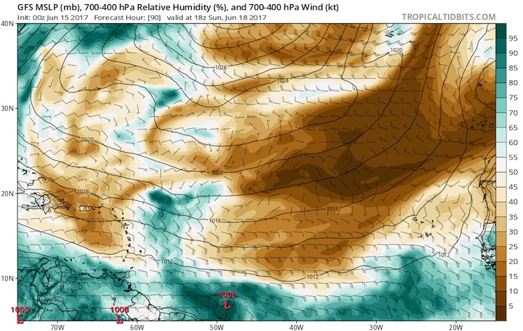
| Figure 3. The operational GFS model from 00Z Thursday, June 15, 2017, brings the tropical wave into the western tropical Atlantic by 2 pm EST Sunday, June 18. The 1006 mb low at the bottom center of the image suggests that the wave could be at depression strength by this point. Relative humidity from about two to four miles above ground (700-400 mb) is predicted to remain quite low just to the north of the system, in the Sahara Air Layer (yellow and brown colors), but conditions are predicted to remain very moist in the immediate vicinity of the system. Image credit: tropicaltidbits.com. |
Climatology does not favor a tropical cyclone forming in the Main Development Region east of the Antilles so early in the year. As we discussed in Wednesday’s post, only one tropical storm and one hurricane have been known to develop in this area during June in records going back to 1851. Of our three most reliable models for predicting tropical cyclone formation several days in advance, the UKMET fails to develop this wave in its 00Z Thursday run. Less than a third of the 50 ECWMF ensemble members from 00Z Thursday develop the wave into a tropical depression by Saturday, with only a couple bringing it to tropical storm strength. The GFS is more supportive, with about half of its 20 ensemble members producing a tropical storm and a couple of members even generating a hurricane over the next five days.
The GFS and ECMWF ensembles agree on a track that would take the wave into the coast of Venezuela or Guyana or perhaps into the southernmost Lesser Antilles early next week. The GFS ensemble tracks are clustered slightly further north, with most members bringing the system into the southeast Caribbean. However, any system entering the Caribbean is likely to encounter progressively stronger wind shear, and none of the GFS and ECMWF ensemble members bring the system fully through the Caribbean. The eastern Caribbean is a notorious “graveyard” for tropical cyclones, especially early in the season, because of persistent divergence at low levels that tends to weaken showers and thunderstorms.
Bob Henson co-authored this post.


