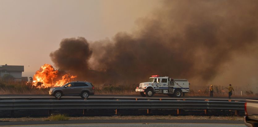
| Above: Firefighters monitor a section of the Thomas Fire along U.S. Highway 101 northwest of Ventura, California, in the predawn hours on Thursday, December 7, 2017. Image credit: Mario Tama/Getty Images. |
Three days of wildfire in and near Los Angeles have left at least one person dead, more than 100,000 acres scorched, more than 200,000 people under evacuation orders, and hundreds of structures lost. The fire-fueling Santa Ana winds weren’t quite as strong as feared on Thursday, but the parched atmosphere was enough to keep several massive fires almost completely uncontained. Relative humidities dropped below 10% on Thursday afternoon—and as low as 2% in parts of San Diego County—as temperatures approached 80°F at lower elevations. Mild, dry weather is expected to continue for at least the next week, with weaker but persistent offshore winds keeping the humidity low.
The Thomas Fire, which spanned some 96,000 acres and was just 5% contained as of 10 am PST Thursday, continued to gobble up new territory west and north of the city of Ventura. More than 15,000 homes were threatened by the blaze. The tiny coastal enclave of Faria Beach was hastily evacuated on Thursday afternoon as flames reached Highway 101, the main route connecting beach communities northwest of Los Angeles. A woman’s body was recovered from a car in a canyon north of Ventura, the first fatality with a possible link to this week’s fires.
By late Thursday, a new blaze—the Lilac Fire—had quickly consumed 2000 acres near the town of Bonsall, about 35 miles north of San Diego. Two injuries were reported and some 1000 homes were at risk. The fire was 0% contained, with evacuation orders in place.
 |
| Figure 1. Vehicles pass fire burning on the south (coastal) side of U.S. Highway 101 in Mondos Beach, west of Ventura, California on Thursday, December 7, 2017. Image credit: Frederic J. Brown/AFP/Getty Images. |
Despite its small size, the Skirball Fire remained a serious threat given its location near the heart of Los Angeles. Evacuations remained in place nearby on Thursday, and classes were cancelled on Thursday at both UCLA and California State University, Northridge, in part due to health and logistics concerns.
 |
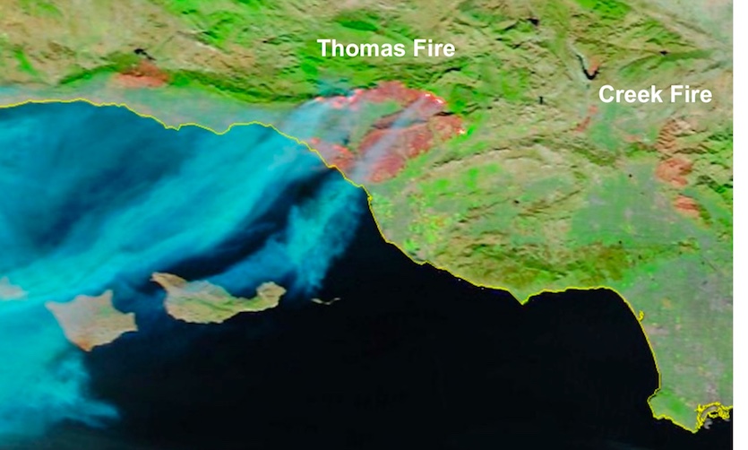
| Figure 2. “False-color” image from NASA’s MODIS instrument aboard the Terra satellite at 10:16 am PST Thursday, December 7, 2017. The colors in this image are optimized to show smoke (in blue) while revealing the burn scars (in brown) left by the large Thomas and Creek fires. Image credit: Scott Bachmeier, CIMSS/University of Wisconsin–Madison. |
Two major fires continued to burn along the perimeter of the San Fernando Valley. As of 11 am PST Thursday, the Creek Fire near Santa Clarita was 10% contained, at 12,605 acres, while the Skirball Fire (the one next to Interstate 405 across from the Getty Center) was 20% contained at 475 acres. Both fires were putting out much less smoke than on Wednesday (see Figure 2 above), and air quality over the valley and central L.A. had improved, though moderate amounts of fine particulates were still present.
South of L.A., just a few blocks from the coast in Huntington Beach, a brush fire that broke out Thursday morning (see embedded video below) was contained in a couple of hours. There was no damage to life or property, but more than a few nerves were frayed.
Just got this sent to me from a buddy out in Huntington Beach. Speaks for itself pic.twitter.com/VnMktnClnj
— Stephen (@Stephen_Springs) December 7, 2017
No rain in the forecast
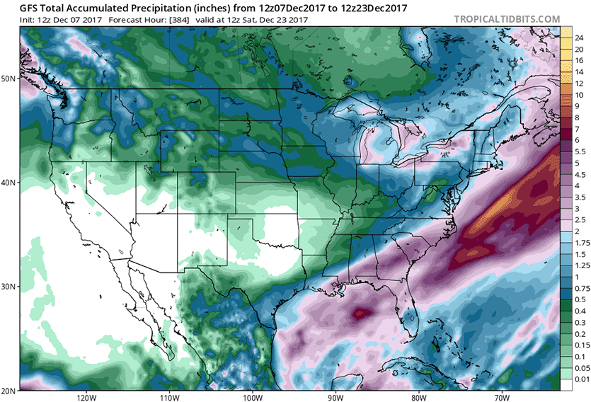
There’s no sign of any thirst-slaking moisture for Southern California in the foreseeable future. The upper atmosphere over North America is locking into a pattern with a very strong ridge near the Pacific Coast, a strengthening trough in the East, and a freight train of northwest flow and cold air funneling into the eastern half of the U.S. and Canada. This pattern will force any potential rain-making low pressure systems well north of Southern and Central California for at least the next 10 days, if current model projections hold. Some relaxation of the pattern is possible beyond that point, but there are no signs right now of any major shift toward wet Pacific storms heading for California.
 |
| Figure 3. The 7 am EST (12Z) Thursday, December 7, 2017 forecast from the GFS model predicted no precipitation for most of California for the next 16 days; less than ½” (green colors) is predicted to fall in portions of Northern California. Successive runs of the GFS have been quite consistent with this overall dry outlook. Image credit: tropicaltidbits.com. |
Is the RRR rearing its head again?
As we noted on Monday, California weather watchers may be getting just a bit of déjà vu. A powerful upper ridge recurred along and near the West Coast for three winters in a row during the state’s five-year drought (2011-2016). The feature came to be known as the Ridiculously Resilient Ridge, a name coined by UCLA climate scientist Daniel Swain that stuck.
New research by Swain and colleagues is shedding more light on the RRR and its connections to sea-surface temperatures in the Pacific. Swain covers the current North American circulation pattern in the context of these new findings in a Monday post at California Weather Blog. The research found that there has been “an increase in the number of days each winter characterized by simultaneously very warm temperatures across the American West and very cold temperatures across the East”, like we will see during most of December 2017. Also, this pattern is “considerably more likely in a climate with rising greenhouse gas concentrations than in a hypothetical climate without human influence.”
Swain's entire post is well worth reading, but the closing paragraph is what resonates the most:
“Tropical warmth (in the West Pacific) and coolness (in the East Pacific) are both linked to different patterns of North Pacific winter ridging, and may offer an early warning of seasons with an elevated risk of dry conditions in California. Interestingly, tropical Pacific Ocean temperatures during autumn 2017 were warm in the west and cool in the east amidst a modest (and ongoing) La Niña event—a combination that suggests a substantially elevated likelihood of West Coast ridging this winter. To date, Southern California has experienced one of its driest starts to the Water Year on record, and strikingly persistent West Coast ridging is now expected to last at least two weeks. It will certainly be interesting to see how this winter plays out in the context of these new research findings.”
How changes in polar sea ice may influence rain and snow in California
A separate study, released this week in the open-access journal Nature Communications, finds that reduced Arctic sea ice could lead to a long-term decrease in precipitation over California, as a result of stronger upper-level ridging over the northeast Pacific. This is a type of long-distance effect called a teleconnection—but in this case occurring through a two-step process, extending from polar regions to equatorial regions and then back to midlatitudes.
The study, led by Ivana Cvijanovic (Lawrence Livermore National Laboratory) used a novel approach to compare global climate between two situations: a “low Arctic ice” scenario (nearly complete sea ice loss during August and September) and a control scenario (sea ice area holding steady at year-2000 values). The study team found that atmospheric effects of the reduced sea ice percolated toward the equator, where they tended to suppress storminess over the central tropical Pacific (see Figure 4). In turn, this fostered a poleward chain of events leading to enhanced ridging and reduced storminess over the northeast Pacific, including most of the U.S. and Canada West Coast. The upshot was a 10-15% drop in model-generated precipitation over California when averaged across a 20-year period.
 |
| Figure 4. Schematic of the two-step teleconnection discussed in the new paper by Ivana Cvijanovic and colleagues. In step 1, Arctic sea-ice loss induced high-latitude changes propagate into tropics, affecting atmospheric circulation and the location of showers and thunderstorms (convection). Decreased convection and decreased upper-level divergence in the tropical Pacific in turn drive a northward-propagating sequence of upward and downward motion (a Rossby wave train) with anticyclonic flow forming in the North Pacific. This ridge is responsible for steering moisture away from California. Image credit: Cvijanovic et al., “Future loss of Arctic sea-ice cover could drive a substantial decrease in California’s rainfall,” Nature Communications 8, doi:10.1038/s41467-017-01907-4; courtesy Nature Publishing Group. |
Interestingly, the new study found that reductions in sea ice around Antarctica could lead to the opposite result—an increase in California precipitation—through a similar two-step process. As it happens, Antarctic sea ice was at record-low extent during the winter of 2016–17, when northern and central California had one of its wettest winters on record. The authors note that any sustained decrease in Antarctic sea ice could be expected to at least partially counteract the long-term drying effect in California from Arctic sea ice loss.
Although California's dryness of the last few years is roughly on par with the magnitude of the expected response from the Arctic, the authors are not yet ready to draw a conclusive link: “This consistency does not…constitute compelling evidence that the 2012–2016 California drought is attributable to Arctic sea-ice changes. Rather, it illustrates that some of the atmospheric features of the droughts driven by Arctic sea-ice loss may resemble those of the most recent California drought.”
At weather.com, Kait Parker has a video exploring this new study.
Dr. Jeff Masters contributed to this post.


