| Above: A motorist drives under downed pine trees resting on power lines in Freeport, Maine, Monday, Oct. 30, 2017. Image credit: AP Photo/Robert F. Bukaty. |
Hundreds of thousands of people in New England could be without power for days, in the wake of a blockbuster mid-latitude storm that produced a patchwork of torrential rains and fierce winds across a broad swath from western New York to Maine. Prodded by a very dynamic upper-level trough, the storm featured an intense surface low that raced from the vicinity of New York to west of Montreal late Sunday night into Monday morning. The low qualified as a meteorological “bomb,” as its central pressure dropped 29 mb in a 24-hour period. South of this low, a strong cold front picked up the remnants of Tropical Storm Philippe in the Northwest Atlantic and slammed them into the coast of Maine early Monday. All told, this “Franken-Philippe” storm could rack up damage on par with many landfalling Category 1 hurricanes.
22.5-hour evolution of east coast storm system ending early this morning. #GOES16 water vapor imagery. From: https://t.co/UbPS1qoe5L pic.twitter.com/aNMN7BU89P
— Bill Line (@bill_line) October 30, 2017
 |
| Figure 1. A toppled tree leans onto a power line after an overnight storm Monday, Oct. 30, 2017, in Brookline, Mass. Image credit: AP Photo/Alanna Durkin Richer. |
More than 1 million customers across the Northeast U.S. lost power during Franken-Philippe, according to weather.com. As of 10 am EDT Monday, more than 350,000 customers across Maine remained without power, with no estimate of when power would be restored. Central Maine Power reported that the power outages affected more than half of the company’s customer base and were more widespread than those from the notorious ice storm of January 1998. “Recovery will take several days,” the utility tweeted.
Strong winds hit many other parts of New York and New England as the multi-pronged Franken-Philippe swept north. Top gusts reported fron Sunday through midday Monday included:
133 mph: Mount Washington, NH
92 mph: Matinicus Rock, ME
78 mph: Isles of Shoals, ME
69 mph: Portland Jetport, ME
67 mph: SUNY-Oswego, NY
63 mph: Burlington, VT
Winds gusting to 130 mph from near the top of the tower! #highwinds #exciting #nhwx #newx pic.twitter.com/al2rOvttbZ
— MWObservatory (@MWObs) October 30, 2017
Winds gusting to 130 mph from near the top of the tower! #highwinds #exciting #nhwx #newx pic.twitter.com/al2rOvttbZ
— MWObservatory (@MWObs) October 30, 2017Lake Ontario is a MONSTER right now at Sodus Point, NY--60 MPH gusts @spann @JimCantore @StephanieAbrams @StormHour @wnywxguy @NWSBUFFALO pic.twitter.com/248JXDTVJO
— John Kucko (@john_kucko) October 30, 2017
Rainfall from Franken-Philippe
Minor to moderate flooding was occurring over parts of New England on Monday, after Franken-Philippe dumped several inches of rain atop ground that was already saturated in some areas by heavy rains over the past week. Just east of Mount Washington, NH, the Saco River was in moderate flood stage. Still approaching its expected crest of 14.4’ at midday Monday, the Saco was already at its highest levels since Hurricane Irene in 2011. Multiple roads were flooded in the area, according to New England Cable News. Heavy rain also fell across several parts of New York state, including the lower Hudson Valley as well as areas near the east end of Lake Erie.
The highest rainfall amounts reported from each state from Friday night up to 10 am EDT Monday, as summarized by NOAA/NWS/WPC, included:
Connecticut: 5.49” (Waterbury-Oxford Airport)
Massachusetts: 3.73” (Fitchburg)
Maine: 3.15” (Bethel)
New Hampshire: 5.19” (Mount Washington)
New Jersey: 5.42” (Randolph)
New York: 4.99” (Armonk)
Pennsylvania: 4.46” (Bellefonte)
Rhode Island: 4.70” (Manville)
Vermont: 4.92” (West Halifax)
 |
| Figure 2. Precipitation for the 24-hour period ending at 8 am EDT Monday, October 30, 2017, as estimated by a multi-sensor blend of data. Image credit: NOAA/NWS/AHPS. |
Storm surges higher than Irene along NY/CT/MA coast
Despite its brief tenure over the Northwest Atlantic, Franken-Philippe generated some significant storm surge—in fact, higher than the storm surge produced by 2011's Hurricane Irene in some cases. (Storm surge refers to the amount of water pushed inland as a result of a storm; storm tide is the storm surge combined with the astronomical tide.) Peak storm surge amounts from the NOAA Tides & Currents page, compared to the peak storm surge from Irene, included:
Sandy Hook, NJ: 4.61’ (Irene: 4.63’)
The Battery, NY: 4.81’ (Irene: 4.36’)
Kings Point, NY: 5.83’ (Irene: 4.46’)
Bridgeport, CT: 5.39’ (Irene: 4.44’)
Providence, RI: 4.34’ (Irene: 4.65’)
Woods Hole, MA: 3.00’ (Irene: 2.87’)
Bar Harbor, ME: 2.47’ (Irene: 1.25’)
The saving grace this time was that the biggest storm surge arrived near low tide, and it peaked and fell quickly, thus averting a large storm surge during high tide. If the highest storm surge from Franken-Philippe had struck The Battery in New York Harbor just a few hours later, during high tide, it could have produced local flooding on par with that from Irene and the December 1992 nor’easter.
Record low barometric pressures for October
One sign of the uncommon strength of this storm: the very low barometric pressures, especially for early- to mid-autumn.
—In Albany, NY, the mean-sea-level pressure dropped to 975.9 mb at 1:51 am EDT Monday. This broke the previous all-time October record of 979.3 mb set on Oct. 26, 1980.
—In Providence, RI, the pressure dropped to 983.3 mb at 3:51 am EDT Monday, breaking the October record of 983.4 mb set on Oct. 26, 2006.
—In Boston, MA, the minimum pressure of 984.3 mb at 6:54 am EDT Monday was just above the October record of 982.4 mb from Oct. 26, 2006.
 |
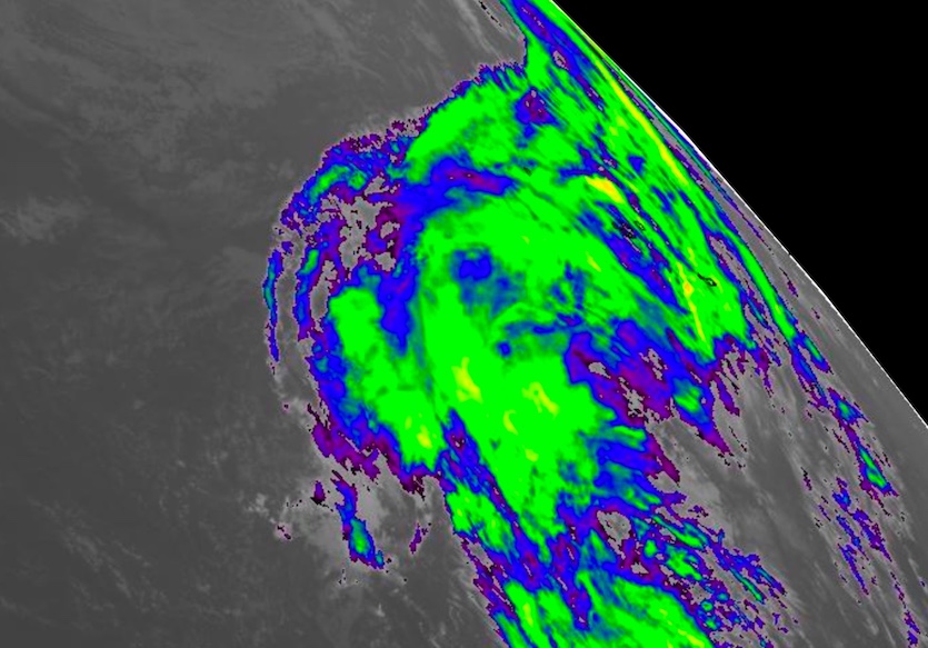
| Figure 3. Showers and thunderstorms stream eastward from a non-tropical low located in the Central Atlantic between Bermuda and the Azores at 2 pm EDT Monday, October 30, 2017. Image credit: NASA/MSFC Earth Science Branch. |
Central Atlantic low could go tropical or subtropical later this week
A strong upper-level trough is now pulling away from a nontropical low-level circulation located about 1000 miles east of Bermuda, and this could give the low a chance to develop later this week. Showers and thunderstorms near the low were being torn eastward on Monday by strong wind shear. Later this week, though, the shear is predicted to relax. Sea-surface temperatures in this region are roughly 0.5 - 1.0°C (1 – 2°F) above average, which makes them marginally warm enough to support tropical or subtropical development (around 26°C or 79°F)—especially if upper-level temperatures are unusually cold, as was the case with Lee, which became a hurricane close to this region in late September.
Around the end of this week, a new upper-level trough will likely pull the low northeastward; whatever develops before that point will remain far from land. In its 2 pm EDT Monday tropical weather outlook, the National Hurricane Center gave this system a 30% chance of becoming at least a tropical or subtropical depression by Wednesday afternoon, and a 40% chance by Saturday.


