| Above: Integrated water vapor transport (IWVT) projected by the GFS model on Wednesday morning for 18Z (11 am PDT) Friday, April 6, 2018. The arrows show the direction and strength at which water vapor integrated upward through the atmosphere is being transported toward Calfornia. Image credit: Center for Western Weather and Water Extremes. |
A powerful late-season atmospheric river is headed for central California late this week, with the potential to bring near-record rains for April and an air mass as soggy as some locations have ever seen. Intense rain rates on Friday night will pose a flood risk in the Sierra Nevada, where the runoff will be bolstered by rain-induced snowmelt. By Saturday, high winds and heavy rains will rake parts of western Oregon and Washington as the center of the sprawling storm moves north along the coast.
“This is really an historic event that is very unusual for this time of the year,” said Cliff Mass (University of Washington) on Wednesday in a blog post.
As of Wednesday morning, the National Weather Service’s Bay Area office was predicting that San Francisco could receive 3-4” of rain from Thursday through Saturday. Downtown San Francisco has only seen a handful of three-day April rains this heavy in records going back to 1849, and only one such April event in the last hundred-plus years!
4.08” Apr. 9-11, 1884
3.72” Apr. 1-3, 1958
3.68" Apr. 19-21, 1880
3.59” Apr. 16-17, 1853
3.20” Apr. 13-15, 1855
In the Sacramento area, the predicted 2-3” of rain would approach records for any April storm going back to 1941:
3.45” Apr. 1-3, 1958
2.48” Apr. 27-29, 1983
2.34” Apr. 10-12, 1982
2.02” Apr. 6-8, 2017
As moist as it gets for central California, any time of year
The most impressive facet of this incoming West Coast storm is how much atmospheric moisture it’ll be hauling. By Friday, a long channel of strong southwest winds—a classic “Pineapple Express”—will extend from the tropical Pacific near Hawaii to the central California coast.
 |
| Figure 1. Strong flow from the tropical Pacific will bring extremely moist air for this time of year across the Southwest U.S. The amount of precipitable water in the air will be more than 5 standard deviations above the seasonal mean over most of central California—a huge departure on the moist side. This forecast is from the 12Z Wednesday run of the GFS model, valid at 11 pm PDT Friday, April 6, 2018. Image credit: tropicaltidbits.com. |
Within the core of this atmospheric river, precipitable water (PW, or the amount of moisture in an imaginary column above a point on the ground) will be running at extremely high levels for any time of year. PW values on the order of 1.50” to 1.80” are predicted to approach the California coast late Friday. The highest PW ever observed at Oakland in 70 years of radiosonde launches is 1.79”, and the highest value for any April is a mere 1.36”, according to the NOAA/SPC Sounding Climatology Page. While the all-time record may be a reach, I’ll be surprised if the April record doesn’t fall. April PW records are also possible in Reno, NV, and Vanderburg AFB, CA.
Surface dew points will likely hit the 55-60°F range throughout central California, which would feel uncommonly humid for a spring day in these parts.
Whoa: amount of atmospheric moisture near Bay Area could approach *all time* record high level on Sat w/incoming #PineappleExpress #AtmosphericRiver at exact time of year when it typically reaches *minimum* value. That's incredible! #CAwx #CAwater h/t @NWSBayArea pic.twitter.com/M3z6Xts2tD
— Daniel Swain (@Weather_West) April 3, 2018
If there’s a silver lining, it’s that this moist atmosphere won’t be lifted as vigorously as is often the case during midwinter storms, thanks to the less-than-extreme dynamics associated with the upper-level low. Otherwise, rainfall amounts would be even more extreme. An atmospheric river’s strength is related to how much water is in an air mass as well as how quickly that air is moving. This week’s storm ranks extremely high on moisture, but the winds are not as strong as with some other ARs.
Overall, the tools used by the Center for Western Weather and Water Extremes are pegging the upcoming AR as “moderate to strong,” according to a CWWE outlook released on Wednesday. "It will feel like a significant mid-winter storm, but it will of a magnitude that we’ve seen several times in the past couple of years," noted Daniel Swain in a California Weather Blog post on Wednesday afternoon.
Still, we’re likely to see widespread 2-5” rainfall amounts at lower elevations of central and northern California, with 5-7” or more of precipitation possible along west-facing slopes of the coastal ranges and the Sierra Nevada. Amounts could reach 10” in the Olympic Mountains of Washington, where an April storm of this magnitude isn’t quite so unusual.
Here is the latest storm total rainfall forecast Thursday through Saturday. Could see some high spots of 7-8" in the coastal mountains. #cawx #castorm #AtmosphericRiver pic.twitter.com/dvpsET6kja
— NWS Bay Area (@NWSBayArea) April 4, 2018
Heads up: Flood threat in California’s mountains and foothills
The most intense rains from this storm can be expected where the center of the atmospheric river happens to intersect the coastal mountains of central California and the more rugged Sierra Nevada. Atmospheric rivers can sometimes bend north or south as upper-level impulses travel along their length, so the exact locations of the most intense rain can be difficult to pin down until the storm is close at hand. Overall, we can expect precipitation to wind down from northwest to southeast over the weekend, as temperature cool and the AR shifts inland.
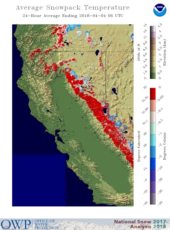
Snow levels in the Sierra will be unusually high for a storm this potent. Rain may fall at altitudes as high as 11,000 feet at the height of the storm, with snow levels dropping closer to 5000 feet as the storm ramps down. This means that intermediate elevations now buried under several feet of snow could experience several inches of rain.
During midwinter, a deep, cold snowpack can absorb a fair amount of rainfall. In this case, though, a large part of the Sierra’s snow has been “ripened,” meaning the temperature throughout the snowpack is close to freezing (see Figure 2). As a result, runoff from heavy rain, especially at elevations below 7000-8000 feet, may be accompanied by rapid snowmelt. A flood watch is already in effect from Friday afternoon into Saturday through the Sierra Nevada and the adjacent foothills. Some flash flooding could develop at the height of the storm, especially where rainfall intensities are highest.
 |
| Figure 2. As of Wednesday, April 4, the average temperature through the depth of the snowpack across most of the Sierra Nevada was only a fraction of a degree below freezing, which means the snowpack is ripe for rapid melting. Image credit: NWS/NOHRSC. |
The NWS office in Reno, Nevada, warned residents on Wednesday: “If you had flooding impacts last November or with more recent storms (March 22nd), you’re likely to have issues with this next storm, probably to a greater degree. Rivers will rise a lot more than earlier storms.”
According to CWWE, the Merced River is predicted to reach its highest stage since 1997, which could end up flooding and closing the main roads leading into Yosemite Valley.
Perhaps surprisingly, the total amount of water held in Sierra snowpack could well be less after this storm than before it. Fortunately, “reservoirs have room and can capture this runoff,” noted the NWS Sacramento office on Wednesday. Most of the big reservoirs in central and northern California are fuller than average for this time of year (in part due to the very wet winter of 2016-17), but are still 10-15% below full capacity.
Overall, the storminess that’s followed a very dry water year through February means that the state is in increasingly better shape for getting through 2018 without major water issues. “California needs two dry years in a row for there to be significant impact to water supplies,” noted Jan Null (Golden Gate Weather Services).
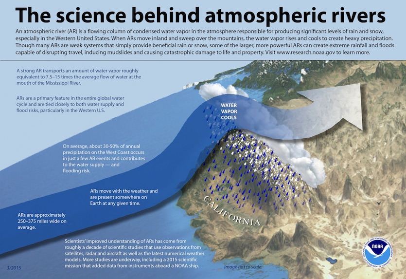
NOAA has a helpful explainer on atmospheric rivers, including a downloadable larger version of the graphic below.
 |


