| Above: WU WunderMap depiction of NWS composite radar, showing the northern eyewall of Hurricane Nate moving onto the coast of Mississippi and Alabama at 11:23 pm CDT Saturday, October 7, 2017. The south side of Nate’s eye was largely devoid of showers and thunderstorms. |
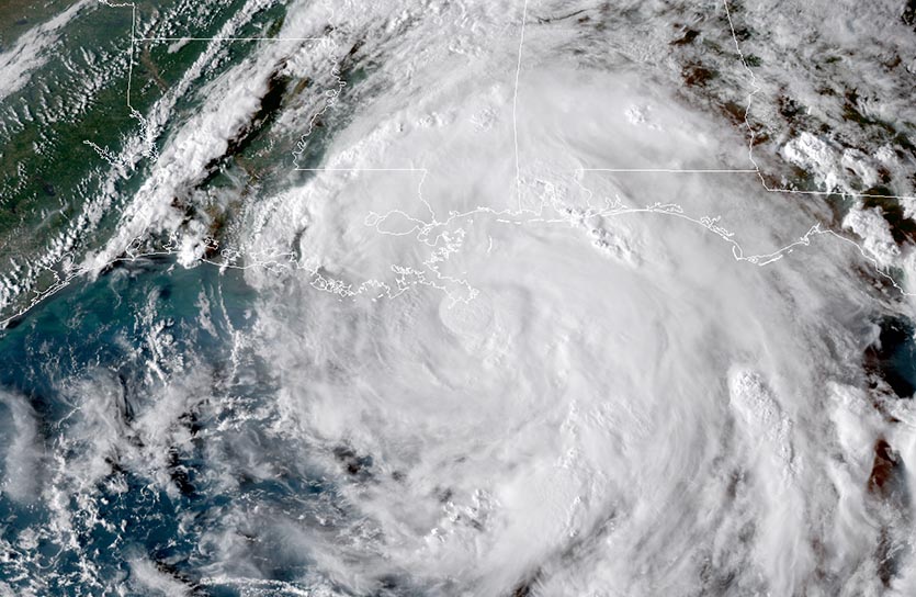
Hurricane Nate made its first U.S. landfall near the mouth of the Mississippi River at around 7 pm CDT Saturday as a Category 1 hurricane. Packing top sustained winds of 85 mph, Nate pushed a compact zone of strong wind and torrential rain onshore across coastal Mississippi and Alabama, just east of its center. Fortunately, Nate never developed a complete, mature eyewall. Had that happened on Friday night, Nate could have rapidly strengthened well into the Category 2 intensity range. Nate is the ninth consecutive Atlantic hurricane of 2017—the most Atlantic hurricanes to occur in a row since 1893. Nate is also the fourth hurricane to reach U.S. shores in the last seven weeks, including Maria’s catastrophic landfall on Puerto Rico and the devastating hits from Harvey in Texas and Irma in Florida. (See our Saturday morning post for more on this hyperactive Atlantic hurricane season.)
At 10 pm CDT Saturday, Nate’s broad eye was moving north at 20 miles an hour, centered about 35 miles south-southwest of Biloxi, MS. Nate’s northern eyewall pushed across the Mississippi and Alabama coasts between 10 and 11 pm CDT. Overall, surface winds in this northern eyewall remained well below hurricane strength. At 10 pm CDT, Kessler Air Force Base in Biloxi reported heavy rain with sustained east winds of 35 mph, gusting to 43—still below tropical storm strength. A gust to 56 mph was recorded at 7:48 pm CDT at Dauphin Island, LA.
 |
| Figure 1. GOES-16 view of Tropical Storm Nate, at 6 pm EDT Saturday, October 7, 2017. Image credit: NOAA/RAMMB. GOES-16 imagery is considered preliminary and non-operational. |
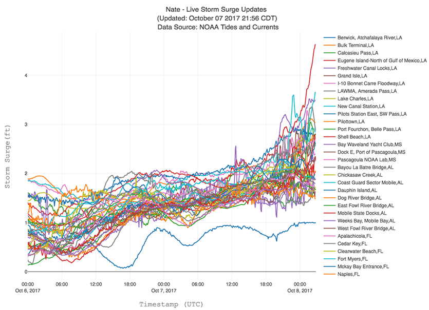
Nate’s storm surge pushed onshore Saturday night just as water levels were approaching high tide, and water levels were rising quickly at several locations along the Mississippi and Alabama coast just before midnight CDT. The surge was entering the lobby of at least one coastal casino in Biloxi. Among the highest surge reports through midnight Saturday night on the NOAA Tides & Currents QuickLook page for Nate:
Shell Beach, LA: 4.8’
New Canal Station, LA: 2.9’
Pilottown, LA: 2.9’
Pascagoula, MS: 3.2’
Waveland, MS: 4.5'
Dauphin Island, AL: 3.0’
Mobile, AL (Coast Guard Station): 4.8’
Pensacola, FL: 2.7’
Panama City, FL: 2.3’
Storm surge coming into parking lot of casino in Biloxi #HurricaneNate pic.twitter.com/CQBnQdG0e7
— Mike Theiss (@MikeTheiss) October 8, 2017
Why did many of the surge amounts from Nate fall short of the peak inundation levels featured in NHC advisories? One reason is that these predicted inundation levels are “worst-case” values, expected to be achieved in only the worst 10% of cases like the current one (thus providing a margin of safety to guide evacuation decisions). As noted by surge expert Dr. Hal Needham, Nate’s surge potential was lessened by its quick motion—which allowed less time for the storm to pile up water along its track—and by its relatively small swath of peak winds.
 |
| Figure 2. Storm surge levels ending at 11 pm EDT Saturday, October 7, 2017 from Hurricane Nate at NOAA tide gauges in Louisiana, Mississippi, Alabama, and the Florida Panhandle. The highest storm surge by this point was 4.7’ at Shell Beach, about 15 miles east-southeast of New Orleans. Shortly afterward, the surge at Shell Beach reached 4.8’ (not shown here). Image credit: SURGEDAT, the Southern Regional Climate Center (www.srcc.lsu.edu), and NOAA Southern Climate Impacts Planning Program (www.southernclimate.org). |
Nate generated some impressively high waves in the northern Gulf of Mexico. At buoy 42040, about 75 miles south of Dauphin Island, AL, wave heights reached 30.2 feet at around 5:50 pm CDT Saturday.
Nate to bring heavy rains across parts of the eastern U.S.
With its less-than-textbook structure allowing for fast decay, and its rapid motion taking it quickly away from its oceanic fuel source, Nate will weaken below hurricane strength by Sunday morning and will likely be a tropical depression by late Sunday night, racing northeast along the Appalachian mountain chain. By Monday night, Nate is expected to be a remnant low moving across southern New England along a preexisting frontal zone. The main product from Nate inland from the coast will be heavy rain, with the totals tempered somewhat by Nate’s quick motion. One stripe of 4 – 6” totals will extend across Alabama into the southern Appalachians, perhaps including Nashville and/or Atlanta. Totals of 4 – 6” are also possible from Kentucky into West Virginia along the front mentioned above. Widespread, beneficial 2 – 4” rains will fall across a broad swath from the Ohio Valley across much of New England.
The rainfall from Nate would be much heavier if Nate were moving more slowly, or if its moisture were gobbled up by a strong midlatitude storm. An envelope of extremely moist air around Nate will merge with a frontal system to produce what could be some of the highest amounts of atmosphere moisture (precipitable water, or PW) ever recorded in October over parts of the Ohio Valley and Northeast. At 7 pm CDT Saturday, a radiosonde measured a PW value of 2.59” at Slidell, LA, the second-highest amount on record for the New Orleans area in October. Below are several of the peak PW amounts predicted by the 00Z Sunday GFS model for the period from Sunday night into Monday morning, compared to the largest PW amounts measured above each location in October since radiosonde measurements began more than 60 years ago. Even if the GFS is overdoing things, this will be a remarkably moist swath of air, and Monday will feel more like a mild, damp August day than an October day across large parts of the Northeast.
Cincinnati, OH: 2.13” (Oct. record 1.98”)
Pittsburgh, PA: 2.18” (Oct. record 2.09”)
Washington, DC: 2.38” (Oct. record 2.42”)
New York, NY: 2.17” (Oct. record 2.31”)
Albany, NY: 2.10” (Oct. record 1.92”)
 |
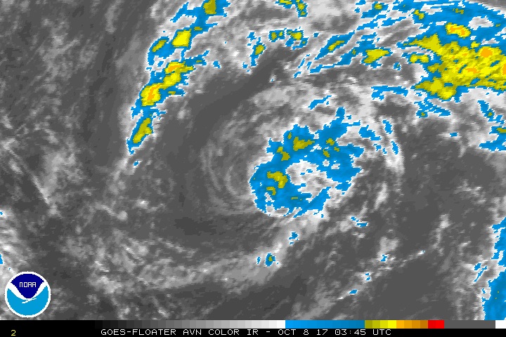
| Figure 3. Infrared satellite image of Invest 91L at 11:45 pm EDT Saturday, October 7, 2017. Image credit: NOAA/NESDIS. |
91L could become a subtropical or tropical cyclone next week
Far out in the remote central Atlantic, about 700 miles southwest of the Azores, a disturbance dubbed Invest 91L has some chance of becoming a named system in the next several days. Conditions around 91L are not especially favorable for development, though. Moderate to strong wind shear of around 15 knots is predicted by the 00Z Sunday SHIPS model to strengthen to the 20 – 30 knot range by late Sunday, and the atmosphere is on the dry side, with mid-level relative humidities only around 45 – 50%. Sea surface temperatures of around 27°C (81°F) are just above the threshold for tropical development. Satellite loops on Saturday night showed a decoupling system, with a midlevel center and its meager amount of showers and thunderstorms (convection) moving away from a low-level center of circulation just to its west.
Despite the negative factors above, NHC’s tropical weather outlook on Saturday night gave 91L a 70 percent chance of becoming at least a tropical or subtropical depression by late Monday. While the SHIPS model supports development into a tropical or subtropical storm, global models are unimpressed, and all in all, 91L has its work cut out for it. If 91L does become our next named system, it will be named Ophelia. It should pose no threat to land, as conditions will become even less supportive by midweek.
Jeff Masters contributed to this post.
#HurricaneNate is set to hit the Gulf Coast around midnight tonight and the @USAFReserve Hurricane Hunters continue to collect data. pic.twitter.com/RegZ8gTiDU
— Hurricane Hunters (@53rdWRS) October 7, 2017


