| Above: A car is partially submerged as it travels beneath a railroad underpass in Fort Wayne, Ind., on Thursday, May 25, 2017, following heavy rains that sparked flash flooding in the northeastern Indiana city. Image credit: Samuel Hoffman/The Journal-Gazette via AP. |
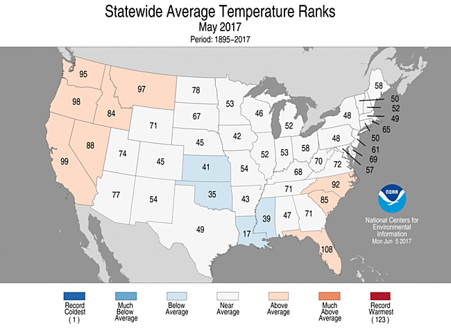
The pace of U.S. record-setting for the contiguous U.S. settled down in May, capping off a warm, wet spring, according to the monthly U.S. climate report from NOAA’s National Centers for Environmental Information. May came in as the 69th warmest and 25th wettest out of 123 years of record for the 48 contiguous states. The thermal mellowness of last month shows up in the state-by-state temperature map (Figure 1). Not a single state had a top-ten warmest or coolest May, although parched Florida had its 15th warmest.
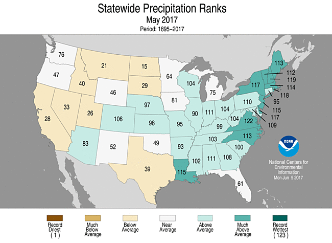
Moisture was abundant in May across the central Plains and most of the nation east of the Mississippi, apart from Florida (see Figure 2). Virginia had its second-wettest May on record, and nine other states made their top-ten-wettest-May lists: Delaware, Louisiana, New Hampshire, New Jersey, New York, North Carolina, Maine, Massachusetts, and Rhode Island.
 |
| Figure 1. Statewide rankings for average temperature during May 2017, as compared to each May since 1895. Darker shades of orange indicate higher rankings for warmth, with 1 denoting the coldest month on record and 123 the warmest. Image credit: : NOAA/NCEI. |
 |
| Figure 2. Statewide rankings for average precipitation during May 2017, as compared to each May since 1895. Darker shades of green indicate higher rankings for moisture, with 1 denoting the driest month on record and 123 the wettest. Image credit: : NOAA/NCEI |
Off to a torrid start: Second-warmest U.S. year on record
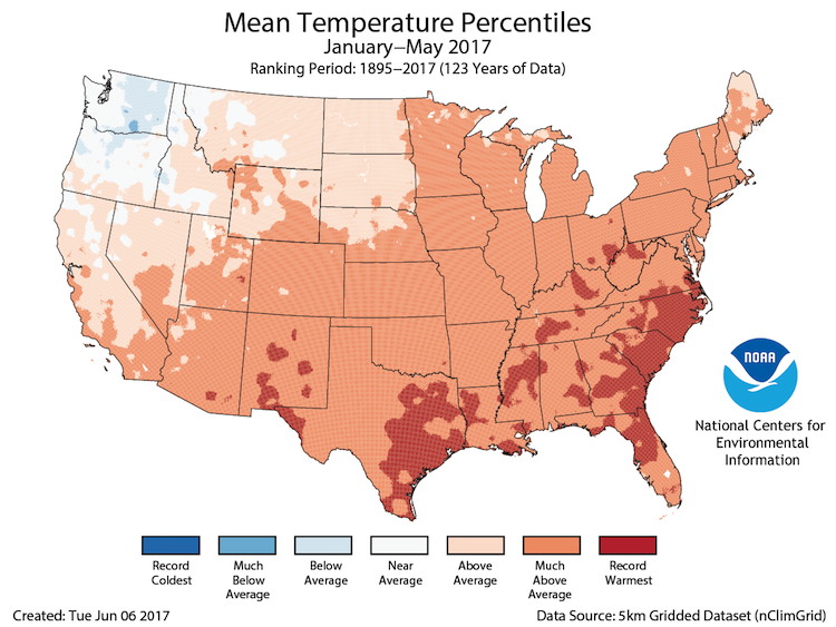
The relatively placid May tapped on the brakes in a year that’s been careening toward record territory for the contiguous U.S. Spring as a whole (March-May) was the 8th warmest and 11th wettest on record, and the year to date (January-May) is the 2nd warmest and 3rd wettest on record.
The only year that came in ahead of 2017 for nationwide warmth during the first five months of the year is 2012. And the only two wetter starts to a year in the contiguous U.S. were in 1983 and 1998—which happen to be the two years that followed the “super” El Niño events of 1982-83 and 1997-98. The only comparable El Niño event in modern records to those two was the one in 2015-16, but that one failed to produce the same boost to U.S. precipitation in the subsequent winter and spring that its two predecessors managed to pull off.
One strong sign that record global warmth over the last three years has been manifesting itself on the national scale: It’s been almost two years since the contiguous U.S. has had a cooler-than-average month. The last one was July 2015.
 |
| Figure 3. Temperatures for the United States for the year to date (January-May 2017) are running at record-warm levels across large parts of the South. Image credit: NOAA/NCEI. |
 |
| Figure 4. Water levels at the Bidwell Marina at Lake Oroville, California, on August 19, 2014 (left) and April 11, 2017 (right). After record rainfall and snow in the mountains, much of California's landscape has turned from brown to green and reservoirs across the state are near capacity. Image credit: Justin Sullivan, Getty Images. |
Drought relief continues
The nation’s abundant moisture this year continues to keep the amount of territory affected by drought at near-record lows. The May 30 installment of the weekly U.S. Drought Monitor showed that only 5.28% of the area of the 50 U.S. states was being affected by drought, just shy of the 21st-century record low of 5.23% observed three weeks earlier. Severe and exceptional drought (the D3 and D4 categories) was affecting just 0.28% of the nation.
Given the generous rains observed across the Florida peninsula in the last week, I won’t be surprised if the drought indices fall to new record lows in the next weekly update, due out on Thursday, June 8. The U.S. Drought Monitor has been compiled since 2000.
After five brutal years, California’s drought has been almost completely erased by a prodigously wet winter. The state saw its fifth wettest October-to-May water year on record. In early April, California’s three-year-long drought emergency was lifted by governor Jerry Brown for all but four counties (Fresno, Kings, Tulare, and Tuolumne), though some water restrictions will remain. Even with the summer dry season now well under way, northern California will get a dose of unusual early-June rain later this week, with amounts of up to an inch in the Sierra and as much as a quarter inch possible in San Francisco.
 |
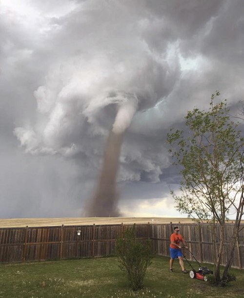
| Figure 5. In this Friday, June 2, 2017, photo provided by Cecilia Wessels via The Canadian Press, Theunis Wessels mows his lawn at his home in Three Hills, Alberta, as a tornado swirls in the background. Cecilia Wessels, who took the image of her husband to show the tornado to her parents in South Africa, said that the twister wasn't as close it appears. Image credit: Cecilia Wessels/The Canadian Press via AP. |
Tornadoes take a partial holiday
In keeping with last month’s fairly tranquil tone, May and early June saw a slackening of the nation’s tornado production. Much of the month’s activity came in a mid-month burst of severe weather, mainly across the Great Plains, Midwest, and Southeast. However, only two tornado-related deaths were reported for the month.
After running at a near-record annual pace in March and April, the total number of U.S. tornadoes (when adjusted for the “inflation” of increased tornado observations over time) has since leveled off. As of June 6, the inflation-adjusted total of 810 for the year to date was well below the record for the date of 1035, though still well above the average to date of 638.
As noted by weather.com, Georgia has been plagued with far more than its share of this year’s tornadic trouble, with 16 fatalities (nearly half of the national total) and what appears to be a record statewide number of twisters.
Tornado activity has been fairly sparse during early June across the contiguous U.S., with the most noteworthy tornado of recent days occurring north of the border: the spectacular twister that twirled across the landscape near Three Hills, Alberta, Canada, north of Calgary. Several people on the scene were unfazed, including the “lawnmower man” who’s become a viral figure in weather circles (see Figure 5).


